
Jackson County, Illinois facts for kids
Quick facts for kids
Jackson County
|
|
|---|---|

Jackson County Courthouse in Murphysboro
|
|

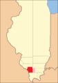
Location within the U.S. state of Illinois
|
|
 Illinois's location within the U.S. |
|
| Country | |
| State | |
| Founded | January 10, 1816 |
| Named for | Andrew Jackson |
| Seat | Murphysboro |
| Largest city | Carbondale |
| Area | |
| • Total | 602 sq mi (1,560 km2) |
| • Land | 584 sq mi (1,510 km2) |
| • Water | 18 sq mi (50 km2) 3.0% |
| Population
(2020)
|
|
| • Total | 52,974 |
| • Estimate
(2023)
|
52,141 |
| • Density | 88.00/sq mi (33.976/km2) |
| Time zone | UTC−6 (Central) |
| • Summer (DST) | UTC−5 (CDT) |
| Congressional district | 12th |
Jackson County is a county in the state of Illinois, USA. About 52,974 people lived here in 2020. The county is located about 98 miles (158 km) southeast of St. Louis.
The main town where the county government is located is Murphysboro. The biggest city is Carbondale. This city is home to Southern Illinois University. Jackson County was started on January 10, 1816. It was named after Andrew Jackson. The county is part of the Carbondale-Marion area. It is also in a part of southern Illinois called "Little Egypt".
Contents
History of Jackson County
People have lived in the Jackson County area for a very long time, about 11,500 years. Native American groups lived here first. European explorers like Joliet and Marquette explored the Mississippi River nearby.
Later, in the 1800s, pioneer farmers began to settle here. They found inexpensive land along the Mississippi River. They also found large forests in the Shawnee hills.
Early Industries
The first coal mine in Illinois was in Jackson County. William Boone and his worker Peter mined coal from the Big Muddy River banks around 1810.
By 1813, Conrad Will ran a large salt factory. It was on the banks of the Big Muddy River, south of where Murphysboro is today. People helped him extract salt from the ground.
County Formation and Name
Jackson County was the ninth county created in Illinois. It was formed in 1816 from parts of Randolph and Johnson Counties. It was named after Andrew Jackson. He was a famous general who had just won the Battle of New Orleans against the British.
The first county seat was a community called Brownsville. In 1843, the courthouse burned down. So, the county decided to move the county seat to a more central spot. This new place became Murphysboro. It was named after William C. Murphy, who helped choose the location.
Civil War Hero
Major General John A. Logan was born in Murphysboro in 1826. He became a very important leader during the American Civil War. Later, he moved to Carbondale.
In 1868, Logan was the leader of the Grand Army of the Republic. He made an order that created Memorial Day as a national holiday. This day honors soldiers who died serving their country.
The Tri-State Tornado
On March 18, 1925, a huge storm called the Tri-State Tornado hit Jackson County. It caused a lot of damage. The villages of Gorham and De Soto, and the city of Murphysboro, were hit very hard.
The Courthouse
The county courthouse is in downtown Murphysboro. The building you see today was finished in 1928. It is made of strong concrete.
-
Jackson County (1816–1818), including unorganized territory (formerly part of Johnson County) temporarily attached to it
-
Jackson County (1818–1827)
-
Jackson County (1827–present)


Geography
Jackson County covers about 602 square miles (1,559 km²). Most of this is land (584 sq mi or 1,513 km²). About 18 square miles (47 km²) is water. The land is usually about 400 feet (122 meters) above sea level. This is true except near the Mississippi River.
The first coal mine in Illinois was on the south bank of the Big Muddy River. This spot is near the Route 127 Bridge today.
Climate and Weather
| Weather chart for Murphysboro, Illinois | |||||||||||||||||||||||||||||||||||||||||||||||
|---|---|---|---|---|---|---|---|---|---|---|---|---|---|---|---|---|---|---|---|---|---|---|---|---|---|---|---|---|---|---|---|---|---|---|---|---|---|---|---|---|---|---|---|---|---|---|---|
| J | F | M | A | M | J | J | A | S | O | N | D | ||||||||||||||||||||||||||||||||||||
|
2.9
39
21
|
3
45
24
|
4.3
55
33
|
4.5
66
42
|
4.8
76
52
|
4.8
84
61
|
3.4
88
66
|
3.9
87
63
|
3.1
80
55
|
2.9
69
43
|
4.6
55
35
|
3.7
44
26
|
||||||||||||||||||||||||||||||||||||
| temperatures in °F precipitation totals in inches source: The Weather Channel |
|||||||||||||||||||||||||||||||||||||||||||||||
|
Metric conversion
|
|||||||||||||||||||||||||||||||||||||||||||||||
The weather in Murphysboro changes throughout the year. In January, the average low temperature is about 21°F (-6°C). In July, the average high is about 88°F (31°C). The coldest temperature ever recorded was -25°F (-32°C) in January 1977. The hottest was 113°F (45°C) in August 1930.
The county gets rain throughout the year. The least rain falls in January, about 2.91 inches (7.4 cm). The most rain falls in May, about 4.78 inches (12.1 cm).
Major Roads
 U.S. Highway 51
 Illinois Route 3
 Illinois Route 4
 Illinois Route 13
 Illinois Route 127
 Illinois Route 149
 Illinois Route 151
Transportation
Local Transit
- Jackson County Mass Transit District
- Saluki Express
- South Central Transit
Intercity Transit
- Amtrak at Carbondale station (trains)
- Greyhound Lines (buses)
- List of intercity bus stops in Illinois
Neighboring Counties
- Perry County (north)
- Franklin County (northeast)
- Williamson County (east)
- Union County (south)
- Cape Girardeau County, Missouri (southwest)
- Perry County, Missouri (west)
- Randolph County (northwest)
Nature Areas
- Crab Orchard National Wildlife Refuge (part)
- Shawnee National Forest (part)
- Giant City State Park
People of Jackson County
| Historical population | |||
|---|---|---|---|
| Census | Pop. | %± | |
| 1820 | 1,542 | — | |
| 1830 | 1,828 | 18.5% | |
| 1840 | 3,566 | 95.1% | |
| 1850 | 5,862 | 64.4% | |
| 1860 | 9,589 | 63.6% | |
| 1870 | 19,634 | 104.8% | |
| 1880 | 22,505 | 14.6% | |
| 1890 | 27,809 | 23.6% | |
| 1900 | 33,871 | 21.8% | |
| 1910 | 35,143 | 3.8% | |
| 1920 | 37,091 | 5.5% | |
| 1930 | 35,680 | −3.8% | |
| 1940 | 37,920 | 6.3% | |
| 1950 | 38,124 | 0.5% | |
| 1960 | 42,151 | 10.6% | |
| 1970 | 55,008 | 30.5% | |
| 1980 | 61,522 | 11.8% | |
| 1990 | 61,067 | −0.7% | |
| 2000 | 59,612 | −2.4% | |
| 2010 | 60,218 | 1.0% | |
| 2020 | 52,974 | −12.0% | |
| 2023 (est.) | 52,141 | −13.4% | |
| US Decennial Census 1790-1960 1900-1990 1990-2000 2010-2013 |
|||

In 2010, there were 60,218 people living in Jackson County. Many different groups of people live here. Most residents are white, but there are also many Black or African American, Asian, and other groups. About 4% of the population is of Hispanic or Latino background.
The average age of people in the county was about 29 years old in 2010. This is younger than many other places. This is because many students attend Southern Illinois University in Carbondale.
Economy
The economy of Jackson County relies a lot on Southern Illinois University Carbondale. The city of Carbondale is growing quickly. It is part of the Metro Lakeland area. This area includes Carbondale, Marion, Herrin, and Carterville.
Jackson County is also close to the Shawnee Hills Wine Trail. This area has many vineyards and wineries.
Communities
Cities
- Ava
- Carbondale
- Grand Tower
- Murphysboro (county seat)
Villages
Census-designated place
Unincorporated communities
Ghost town
Townships
- Bradley
- Carbondale
- DeSoto
- Degognia
- Elk
- Fountain Bluff
- Grand Tower
- Kinkaid
- Levan
- Makanda
- Murphysboro
- Ora
- Pomona
- Sand Ridge
- Somerset
- Vergennes
Images for kids
-
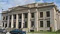
Jackson County Courthouse in Murphysboro
See also
 In Spanish: Condado de Jackson (Illinois) para niños
