
Kano facts for kids
Quick facts for kids
Kano
|
||
|---|---|---|
|
City
|
||
   .jpg) .jpg)  Left to right from top:
Gidan Rumfa/Emir's Palace, the Ancient Kano City Walls, courtyard of Gidan Makama, city neighborhood, traditional dyer at the Kofar Mata Dye Pits, and city skyline from Dalla Hill |
||
|
||

Kano
Location in Nigeria

Kano
Location in Africa
|
||
| Country | ||
| State | Kano State | |
| Area | ||
| • City | 499 km2 (193 sq mi) | |
| • Urban | 251 km2 (97 sq mi) | |
| Elevation | 488 m (1,601 ft) | |
| Population
(2006 census)
|
||
| • City | 2,828,861 | |
| • Estimate
(2021)
|
4,103,000 | |
| • Rank | 2nd | |
| • Density | 5,669/km2 (14,683/sq mi) | |
| • Urban | 3,550,000 | |
| • Urban density | 14,100/km2 (37,000/sq mi) | |
| Time zone | UTC+1 (WAT) | |
| Climate | Aw | |

Kano is a big city in northern Nigeria and the capital of Kano State. It is the second largest city in Nigeria after Lagos. Over four million people live in Kano, which covers about 449 square kilometers.
The city is located in the Savanna region, just south of the Sahel. Kano has been an important center for trade and people for thousands of years. It was a major stop on the trans-Saharan trade routes, which were ancient paths across the Sahara Desert.
Kano is also a traditional state ruled by the Dabo dynasty. Since the 1800s, these rulers have been known as emirs. Today, the Kano Emirate Council is the traditional governing body within the city. It works under the Government of Kano State.
Kano was one of the medieval Hausa seven kingdoms. Most people living in the city are Hausa people. For centuries before British rule, Kano was a very diverse city. Many different groups lived there, including Arabs, Berbers, Tuareg, Kanuri, and Fula. It still is diverse today, and the Hausa language is spoken by over 70 million people in the region.
Islam arrived in Kano around the 11th century or even earlier. It came mainly through the trans-Saharan trade. Because of this trade, Kano became very rich and a key business hub for the region and Northern Nigeria. It is still known as the "center of commerce" today.
Contents
City Name
Kano was first called Dala, named after Dalla Hill. People used this name until the late 1400s or early 1500s.
History of Kano
Early Beginnings

In the 600s, Dala Hill in Kano was home to people who hunted, gathered, and worked with iron. We don't know if these were Hausa people or other groups.
The Kano Chronicle, a historical record, tells us about Barbushe. He was a warrior priest of Dala Hill and came from the first families who settled the city.

While there were small leaders before, Bagauda became the first king of Kano in 999. He ruled until 1063. His grandson, Gijimasu, started building city walls around Dala Hill. His son, Tsaraki, finished these walls.
Middle Ages: Islam and Trade Grow
In the 1100s, King Ali Yaji of Kano became Muslim. He started the Sultanate of Kano, which lasted until the 1800s. Yaji's rule led to Kano growing into a powerful empire.

In 1463, Muhammad Rumfa became king. During his time, Kano became a very important trading center. Many people believe that Leo Africanus described Kano during Rumfa's rule. He wrote that the people were "wealthy merchants and skilled craftsmen." He also noted that there was plenty of rice, corn, cotton, and citrus fruits.
Rumfa improved the city and expanded the Sahelian Gidan Rumfa (Emir's Palace). He also encouraged more people to become Muslim. The Kano Chronicle says Rumfa made twelve important changes to the city.
Later, Mohammed Sharef ruled from 1703 to 1731. His successor, Kumbari dan Sharefa, fought many battles with Sokoto.
Fulani Rule and Trade

In the early 1800s, a Fulani Islamic leader named Usman dan Fodio led a religious war called a jihad. This war ended the old Habe kingdom. Kano then became an Emirate under the new Sokoto Caliphate. Kano was already the largest and richest part of this new empire.
The city faced several periods of hunger from 1807 to 1890.

During the 1800s, Kano continued to be a busy center for trade. Goods like woven cloth, dyed fabrics, and leather products were sold as far north as Morocco and then to Europe. Cotton cloth from Kano reached places like Tripoli, Lake Chad, and Timbuktu.
In 1851, a German scholar named Heinrich Barth visited Kano. He said Kano had 30-foot-high clay walls that were 10 miles long. He estimated the city had 30,000 people. Barth called Kano the greatest trade hub in central Africa. He noted that its large market was full of narrow paths where everything from vegetables to goods was sold.
From 1893 to 1895, two brothers fought a civil war for the throne, known as the Basasa. Yusufu won and became the emir.
British Rule and Independence

In March 1903, the British took over Kano after the Battle of Kano. The city quickly became an important administrative center for Northern Nigeria.
From 1913 to 1914, Kano suffered a major drought and hunger. Other famines happened during British rule in 1908, 1920, 1927, 1943, 1951, 1956, and 1958. By 1922, Alhassan Dantata, a peanut trader, became the richest businessman in the Kano Emirate.

In May 1953, a riot broke out in Kano. This happened because southern newspapers wrongly reported on a disagreement between politicians. Many people died in the riot.
Ado Bayero became the emir of Kano in 1963. Kano State was created in 1967 by the military government of Nigeria. The first military police commissioner, Audu Bako, helped build a strong foundation for modern Kano. He started many development projects, like roads and a good water supply. He also built dams for irrigation, helping Kano produce and export many farm products.
In 2014, Emir Ado Bayero passed away after ruling for over fifty years. Sanusi Lamido Sanusi, a grandson of a former emir, became the new Emir of Kano.
In 2019, the governor changed the traditional Kano Emirate into four new emirates. This meant the Emir of Kano would rule over fewer local government areas. On March 9, 2020, Sanusi was removed from his position as emir.
Geography
Location
Kano is located south of the Sahara Desert. It is in the Sudanian Savanna region, which stretches across the south of the Sahel. The city is near where the Kano and Challawa rivers meet to form the Hadejia River. This river eventually flows into Lake Chad to the east.
Climate
Kano is about 481 meters (1,578 feet) above sea level. It has a tropical savanna climate. The city gets about 980 mm (38.6 inches) of rain each year. Most of this rain falls from June to September.
Like most of Nigeria, Kano is very hot for most of the year. The hottest month is April. From December to February, the city is less hot. Morning temperatures during these months are usually between 14 and 16 °C (57 and 61 °F).
| Climate data for Kano (1981-2010) | |||||||||||||
|---|---|---|---|---|---|---|---|---|---|---|---|---|---|
| Month | Jan | Feb | Mar | Apr | May | Jun | Jul | Aug | Sep | Oct | Nov | Dec | Year |
| Mean daily maximum °C (°F) | 29.0 (84.2) |
32.4 (90.3) |
36.4 (97.5) |
39.1 (102.4) |
37.1 (98.8) |
35.4 (95.7) |
32.0 (89.6) |
30.9 (87.6) |
32.3 (90.1) |
34.5 (94.1) |
33.1 (91.6) |
29.9 (85.8) |
33.5 (92.3) |
| Mean daily minimum °C (°F) | 13.7 (56.7) |
16.2 (61.2) |
20.4 (68.7) |
24.5 (76.1) |
25.0 (77.0) |
23.7 (74.7) |
22.1 (71.8) |
21.2 (70.2) |
21.9 (71.4) |
21.2 (70.2) |
17.1 (62.8) |
14.2 (57.6) |
20.1 (68.2) |
| Average rainfall mm (inches) | 0.0 (0.0) |
0.7 (0.03) |
1.9 (0.07) |
8.1 (0.32) |
71.3 (2.81) |
118.7 (4.67) |
209.0 (8.23) |
311.2 (12.25) |
137.0 (5.39) |
14.1 (0.56) |
1.0 (0.04) |
0.0 (0.0) |
873 (34.37) |
| Average rainy days | 0 | 0 | 1 | 2 | 8 | 11 | 17 | 21 | 14 | 2 | 1 | 0 | 72 |
| Average relative humidity (%) (at 15:00 LST) | 17.0 | 13.2 | 13.2 | 19.1 | 29.5 | 44.5 | 58.9 | 63.6 | 55.0 | 30.1 | 18.1 | 17.4 | 31.6 |
| Mean monthly sunshine hours | 244.9 | 232.4 | 238.7 | 234.0 | 263.5 | 261.0 | 229.4 | 220.1 | 240.0 | 266.6 | 264.0 | 260.4 | 2,955 |
| Mean daily sunshine hours | 7.9 | 8.3 | 7.7 | 7.8 | 8.5 | 8.7 | 7.4 | 7.1 | 8.0 | 8.6 | 8.8 | 8.4 | 8.1 |
| Source 1: World Meteorological Organization & Danish Meteorological Institute (rainfall & rain days) | |||||||||||||
| Source 2: NOAA (sun and relative humidity, 1961–1990) | |||||||||||||
City Districts
Kano has forty-four local government areas. Some of the main ones are:
- Kano municipal
- Dala
- Fagge
- Tarauni
- Gwale
- Ungoggo
- Kumbotso
- Nassarawa

Economy
Kano's economy has a long history, going back to the Middle Ages. The city was the southernmost point of the famous trans-Sahara trade routes. Kano was well connected to many cities in North Africa and parts of southern Europe.
By 1851, Kano produced millions of sandals and tanned hides each year for export. Other products included textiles, leather, and grains. Kano became connected to trans-Atlantic trade in 1911 when a railway line reached the city. Today, Kano is a major center for growing and exporting farm products like hides, skins, peanuts, and cotton.
The city's economy is still strong today. Aliko Dangote, Africa's richest man, comes from Kano. His great-grandfather, Alhassan Dantata, was the richest West African in the mid-1900s.
Sometimes, government policies and power outages have made it hard for factories to grow. So, Kano's economy mainly depends on trade, shops, and services. There are plans to build a special area for information technology in the city.
Culture
Horse Riding and Festivals

Kano has a strong tradition of horse riding. This is clearly seen during the annual Durbar festival. This festival celebrates two important Muslim holidays: Eid al-Fitr (marking the end of Ramadan) and Eid al-Adha (marking the Hajj pilgrimage).
The festival starts with skilled horsemen from the royal court and nobles. They ride through the city in a colorful procession, joined by musicians and others, on their way to the emir's palace. Once at the palace, the horsemen ride in groups towards the emir. They stop just in front of him to show their respect. During the festival, the emir makes a grand appearance, dressed in beautiful royal clothes.
In 2012, the Durbar festival was canceled for the first time in 200 years. This was due to the emir's health and also rising attacks by Boko Haram in northern Nigeria at that time.
Architecture
Kano's buildings have changed a lot over the years, from traditional styles to modern ones. The city is a leading example of Sudano-Sahelian architecture. It developed the local Tubali style, seen in its mosques, walls, homes, and gates.
The outside designs of buildings are very important in Kano. The city has many skilled artists who create these designs.
Important Places

Old City
The Old City of Kano used to be surrounded by walls. Most of the gates to this old city still stand today. Inside the Old City, you can find the large Kurmi Market, famous for its crafts. Old dye pits, which are still used, are also nearby. The Emir's Palace, the Great Mosque, and the Gidan Makama Museum are all in the Old City.
Places of Worship
Most of the places of worship in Kano are Muslim mosques.
There are also Christian churches for different groups, including:
- Church of Nigeria (Anglican Communion)
- Roman Catholic Diocese of Kano (Catholic Church)
- Nigerian Baptist Convention (Baptist World Alliance)
- Presbyterian Church of Nigeria (World Communion of Reformed Churches)
- Pentecostal megachurches like Assemblies of God, Living Faith Church Worldwide, and Redeemed Christian Church of God.
City Defenses
The Ancient Kano City Walls were built for defense. King Gijimasu started building the foundation in the 1000s. The walls were finished in the mid-1300s and expanded in the 1500s. In 1903, Fredrick Lugard, a British governor, wrote that he had "never seen anything like it in Africa" after capturing Kano.
Old Palaces and Homes
Many old royal homes still exist today, mostly within and around the Old City. These include private houses like the Gidan Chiroma and Filin Chiranchi. Larger palaces include the Gidan Rumfa, Gidan Makama, and a winter retreat for the emir.
Education

Universities
Bayero University Kano is the oldest university in the city. It was founded in 1962 by Isa Kaita. It became a state university in 1975 and is still an important learning center today.
The Kano State Polytechnic was founded in 1975.
Transportation

Kano has a railway station with trains that go to Lagos through Kaduna. The Mallam Aminu Kano International Airport is also nearby. The city gets its water from the Challawa Gorge Dam, which might also be used to create electricity. Because Kano is north of the Kaduna rail junction, it can easily reach the seaports at Lagos and Port Harcourt.
Airlines like Kabo Air and Azman Airlines used to have their main offices in Kano. Today, Max Air and many travel agencies are based there.

After many years, the railway line from Kano to Lagos was fixed by 2013. A train trip to Lagos takes 30 hours and costs about US$12, which is much cheaper than a bus ticket.
In 2014, a new, modern railway line from Lagos began construction.
From 2006 to 2015, with high oil prices, the state government built many major highways, bridges, and other transport structures. Some notable ones include the Silver Jubilee flyover bridge at Kofar Nassarawa and the Kofar Kabuga underpass.
In 2017, plans for a 74-kilometer, four-line light rail network were announced. A US$1.8 billion contract was signed with China Railway Construction Corporation.
Notable People
- Sani Abacha, former Nigerian Head of State
- Lawan Musa Abdullahi, lawyer and politician
- Aliko Dangote, businessman
- Alhassan Dantata, businessman
- Abdullahi Umar Ganduje, former Governor of Kano State
- Rabiu Kwankwaso, politician, former Governor of Kano State and former Minister of Defense
- Murtala Mohammed, former Head of States, Federal Republic of Nigeria
- Isyaku Rabiu, businessman
- Muhammadu Abubakar Rimi, former Governor of Kano State
- Sanusi Lamido Sanusi, banker
- Ibrahim Shekarau, politician, former Governor of Kano State and former Minister of Education, currently a Nigerian Senator
- Abdullahi Aliyu Sumaila, bureaucrat and politician
- Alhassan Yusuf, footballer
Images for kids
-
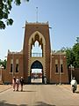
Gidan Rumfa/Emir's Palace
-
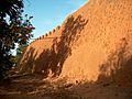
Ancient Kano City Walls
-
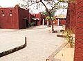
Courtyard of Gidan Makama Museum
-
City neighborhood
-
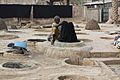
Traditional dyer at the Kofar Mata Dye Pits
-
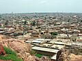
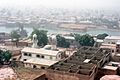
City skyline from Dalla Hill
See also
 In Spanish: Kano (desambiguación) para niños
