
Karur facts for kids
Quick facts for kids
Karur
|
|
|---|---|
 |
|

Karur
Location in Tamil Nadu

Karur
Location in India
|
|
| Country | |
| State | Tamil Nadu |
| District | Karur |
| Government | |
| • Type | Municipal Corporation |
| • Body | Karur Municipal Corporation |
| Area | |
| • Total | 53.26 km2 (20.56 sq mi) |
| Elevation | 147 m (482 ft) |
| Population
The population as per 2011 census was calculated basis pre-expansion area of 5.96 sq.km. was 70,980. Post expansion of city limits to 52.26 sq.km., the population including the new city limits was estimated to be 394,719 in 2024 by unofficial sources.
|
|
| • Total | 394,719 |
| Languages | |
| • Official | Tamil |
| Time zone | UTC+5:30 (IST) |
| PIN |
639(xxx)
|
| Telephone code | 91-(0)4324 |
| Vehicle registration | TN-47 |
Karur (Tamil: [kaɾuːɾ]) is a big city in the Indian state of Tamil Nadu. It is the main office for the Karur district and is managed by the Karur Municipal Corporation. The city is located by the Amaravathi, Kaveri, and Noyyal rivers. It is about 395 kilometers southwest of Chennai, the state capital.
Long ago, the Cheras ruled this area during the Sangam period. Karur was an important trading spot between India's west coast and Tamil Nadu. Old findings show that Karur was a busy trade center during the Chera rule. Later, the Cholas, Pandyas, Vijayanagara Empire, and Madurai Nayaks also ruled here. In the late 1700s, the Kingdom of Mysore took control, but then the British East India Company made it part of the Madras Presidency in 1799. After India became independent in 1947, Karur joined Madras State, which later became Tamil Nadu.
The city's economy mainly depends on agriculture and making textiles (cloth). Most people in Karur are Hindus, with smaller groups of Muslims and Christians. Tamil is the main language spoken here. Karur is also part of the Karur Assembly constituency, which chooses a representative for the Tamil Nadu Legislative Assembly every five years.
Contents
What's in a Name? The Meaning of Karur
The name "Karur" comes from Karuvur, which was the capital city of the Chera kingdom. In the Tamil language, "Karu" means "embryo" and "Oor" means "town" or "place." So, Karur literally means "embryo town."
This name might come from Hindu mythology, where it's linked to the creator god Brahma. Because of this, the city was sometimes called Brahmapuri in the past. People also used other names for the town, like Tiruvanilai and Pasupati.
Karur's Rich History
The Cheras, one of the three main kingdoms of the Sangam period (from 3rd century BC to 3rd century CE), ruled this area. Their capital was at Vanchi-Karuvoor. Some historians believe this capital was the same as modern-day Karur in Tamil Nadu. Karur, known as Karuvur back then, was part of the ancient Kongu Nadu region and is one of the oldest inhabited towns in the state. Digs at Kodumanal, near Karur, show signs of people living there as early as 4th century BCE.

Old findings show that Karur was a busy trading center during the Chera period. The famous Tamil story Silapathikaram mentions that the Chera king Senguttuvan ruled from Karuvur. Archeologists have found pottery, bricks, toys made of mud, Roman jars (called Amphorae), special coated pottery, rings, and coins from different times in Karur. It seems Karur was also a center for making old jewelry and setting gems.
Around 150 CE, a Greek scholar named Ptolemy called "Korevora" an important trading center in South India. This area was part of an ancient Roman trade route that went from Muziris on India's west coast to Arikamedu on the east coast. Early Tamil Brahmi writings have been found on coins, seals, and rings from the Amaravati River bed near Karur.
Rulers Through the Ages
The Pandyas took control of the region in the seventh century CE under King Arikesari Maravarman. Later, other groups like the Rashtrakutas and Western Gangas ruled here. The Cholas, led by Aditya I, conquered the area in the ninth century CE. The Imperial Cholas directly ruled until 1064 CE. After that, the Kongu Cholas, who were likely rulers under the main Cholas, governed the region on their own. Temple writings near Karur from the time of Kulothunga Chola I call the place Vanchimanagarama Karuvur (Vanchi city of Karuvur).
Later, the Vijayanagara Empire and the Madurai Nayaks, who were once under Vijayanagara, ruled Karur. In the late 1600s, the Kingdom of Mysore gained influence. In the late 1700s, the control of Karur changed many times between the Mysore Kingdom and the British East India Company. In 1790, the British captured it for the third time, and the Karur fort remained a British military base until 1801.
Under the British Raj, Karur became part of the Madras Presidency and was an important administrative center. The Karur municipality was formed in 1874. After India became independent in 1947, the region was part of the Madras State. In 1956, when state borders were reorganized, most of the region became part of the new Madras state, which was renamed Tamil Nadu in 1969.
Karur's Geography and Landscape

Karur is located at 10.95° N latitude and 78.08° E longitude. It is about 101 meters (331 feet) above sea level. The city is in the Karur district, about 370 kilometers from Chennai. Karur sits on the banks of the Amaravathi, Kaveri, and Noyyal rivers, and the land is mostly flat. There are no major mineral resources found nearby. The soil is black and red, which is good for growing common crops in the Cauvery delta region.
Karur's Climate
Karur has a hot semi-arid climate. This means it's generally hot and dry. Temperatures can go from a high of 39°C (102°F) to a low of 17°C (63°F). The average temperature is around 28.7°C (83.7°F). The hottest months are from April to June, and the coolest are December to January. May is usually the hottest month, with an average of 31.5°C (88.7°F), while December is the coolest, averaging 25.6°C (78.1°F).
Karur gets about 590 to 600 millimeters (23 to 24 inches) of rain each year. This is much less than the state average of 1008 millimeters (40 inches). The Southwest monsoon, which starts in June and lasts until August, brings very little rain to Karur. This is because the city is in the rain shadow region of the Western Ghats mountains. Most of the rain comes from the Northeast monsoon in October and November. October is the wettest month, with an average of 166 millimeters (6.5 inches) of rain. March is the driest month, with only about 8 millimeters (0.3 inches) of rain.
| Climate data for Karur | |||||||||||||
|---|---|---|---|---|---|---|---|---|---|---|---|---|---|
| Month | Jan | Feb | Mar | Apr | May | Jun | Jul | Aug | Sep | Oct | Nov | Dec | Year |
| Mean daily maximum °C (°F) | 31.1 (88.0) |
33.7 (92.7) |
36.2 (97.2) |
37.0 (98.6) |
37.1 (98.8) |
35.6 (96.1) |
34.3 (93.7) |
34.2 (93.6) |
33.9 (93.0) |
32.5 (90.5) |
30.7 (87.3) |
29.4 (84.9) |
33.8 (92.9) |
| Daily mean °C (°F) | 25.8 (78.4) |
27.5 (81.5) |
29.7 (85.5) |
31.3 (88.3) |
31.5 (88.7) |
30.6 (87.1) |
29.6 (85.3) |
29.4 (84.9) |
29.1 (84.4) |
28.1 (82.6) |
26.6 (79.9) |
25.6 (78.1) |
28.7 (83.7) |
| Mean daily minimum °C (°F) | 20.5 (68.9) |
21.3 (70.3) |
23.2 (73.8) |
25.7 (78.3) |
26.0 (78.8) |
25.6 (78.1) |
24.9 (76.8) |
24.6 (76.3) |
24.3 (75.7) |
23.7 (74.7) |
22.5 (72.5) |
21.8 (71.2) |
23.7 (74.6) |
| Average rainfall mm (inches) | 11.5 (0.45) |
9.2 (0.36) |
8.3 (0.33) |
32.4 (1.28) |
63.5 (2.50) |
17.1 (0.67) |
30.2 (1.19) |
44.6 (1.76) |
63.2 (2.49) |
166.3 (6.55) |
86.3 (3.40) |
61.0 (2.40) |
593.6 (23.38) |
| Average rainy days | 2 | 1 | 1 | 3 | 5 | 2 | 3 | 4 | 6 | 10 | 9 | 6 | 52 |
| Source 1: Climate-Data.org | |||||||||||||
| Source 2: rainy days | |||||||||||||
People and Population in Karur
| Religious census | ||||
|---|---|---|---|---|
| Religion | Percent(%) | |||
| Hindu | 91.41% | |||
| Muslim | 5.62% | |||
| Christian | 2.88% | |||
| Sikh | 0.01% | |||
| Buddhist | 0.01% | |||
| Other | 0.07% | |||
| No religion | 0.01% | |||
According to the 2011 census, the population within the original city area was 70,980 people. After the city limits expanded, the population, including the new areas, was estimated to be 394,719 in 2023. In 2011, for every 1,000 males, there were 1,032 females, which is more than the national average. About 6,147 children were under six years old.
Around 12.1% of the population belonged to Scheduled Castes and Scheduled Tribes. The average literacy rate (people who can read and write) was 81.7%, which is higher than India's average of about 73%. The city had 57,687 homes. Most people work in the service industry, followed by agriculture and manufacturing.
Most people in Karur are Hindus, then Muslims, and then Christians. Tamil is the main language spoken in the city. English is also commonly used in schools and offices.
Karur's Culture and Temples

Karur was part of the old Chera and Chola empires, so it has many temples. Karuvurar, a famous person born in medieval Karur, was one of nine people who sang the holy songs called Thiruvichaippa. This collection is part of the ninth Thirumurai.
Besides the Pasupatheeswarar Siva temple, there is also a Vishnu temple at Thiruvithuvakkodu. This temple was praised by Kulasekaraazhvaar (who lived in the 7th-8th century CE). It is thought that this temple was mentioned in the epic story Silappadikaram as the place where Cheran Senguttuvan sought blessings before his journey to North India.
Karur's Economy and Industries

About 19% of Karur's land is used for farming. The main crops grown are rice, cotton, sugarcane, and oil seeds. For fruits and other plants, people grow coconut, banana, betel, and mango. Karur is a central place for trading farm products from nearby towns and villages. Most workers (about 80%) are in the service sector, like banking or retail. About 17% work in farming, and 4% in manufacturing.
Many banks have branches in Karur. Two private banks, Karur Vysya Bank and Lakshmi Vilas Bank, have their main offices here.
The Textiles industry is very important in Karur. This includes businesses like ginning (separating cotton fibers), spinning mills (making yarn), dyeing factories, and weaving. As of 2005, this industry made about 20 billion Indian Rupees every year. Karur also has a special area called an integrated textile park, which helps textile businesses.
Karur is also a major center for building bus coaches. A large number of bus bodies are built right here in the city. About 2000 businesses in Karur are involved in making High-density polyethylene (HDPE) mono filament yarn and related products.
TNPL, supported by the Government of Tamil Nadu, is located near Karur. It is one of the biggest paper producers in India. Bharat Petroleum has a pipeline from Kochi to Karur to transport petroleum products. These products are then sent to other districts of Tamil Nadu by tanker trucks. The Chettinad Group also runs a cement plant near Karur.
Getting Around Karur: Transport
The city manages 412.24 kilometers of roads. This includes 55.2 kilometers of concrete roads, 79.33 kilometers of gravel roads, and 275.3 kilometers of paved roads. The State Highways Department maintains 8.375 kilometers of state highways, and the national highways department maintains 26.69 kilometers of national highways. Two national highways, NH 44 and NH 67, pass through Karur.
The Karur bus stand is located in the center of the city. The State Express Transport Corporation runs long-distance buses to other cities. The Tamil Nadu State Transport Corporation operates city buses and buses to other parts of Tamil Nadu and neighboring states. Buses from Karnataka State Road Transport Corporation and Kerala State Road Transport Corporation also connect Karur to Karnataka and Kerala.

The Karur Junction railway station (station code - KRR) is an important railway junction. It is part of the Salem division of the Southern Railway zone of the Indian Railways network. It has five active platforms and is where the Erode-Tiruchirapalli and Salem-Karur railway lines meet. The closest airport is the Tiruchirapalli International Airport, which is 78 kilometers away.
Education in Karur
Karur has 10 government schools. These include four primary schools, four middle schools, and two higher secondary schools. There are also several colleges and other places for higher education in the city. The Karur medical college was opened in 2019.
Images for kids
-
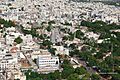
Karur city skyline
See also
 In Spanish: Karur para niños
