Keal Cotes facts for kids
Quick facts for kids Keal Cotes |
|
|---|---|
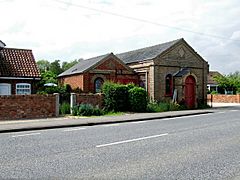
 Former Wesleyan Chapel, Keal Cotes in 2007 |
|
| Population | 327 (2011) |
| OS grid reference | TF365611 |
| • London | 110 mi (180 km) S |
| Civil parish |
|
| District | |
| Shire county | |
| Region | |
| Country | England |
| Sovereign state | United Kingdom |
| Post town | SPILSBY |
| Postcode district | PE23 |
| Dialling code | 01790 |
| Police | Lincolnshire |
| Fire | Lincolnshire |
| Ambulance | East Midlands |
| EU Parliament | East Midlands |
| UK Parliament |
|
Keal Cotes is a small, long village in Lincolnshire, England. It's part of the West Keal parish. You can find it on the A16 road, about 1 mile (1.6 km) south of West Keal. The nearest big town is Spilsby, which is about 6 miles (9.7 km) north. Keal Cotes has a market day on Mondays.
The village sits at the southern edge of the Lincolnshire Wolds, just north of the Fenlands. It's about 25 miles (40 km) east of Lincoln, 11 miles (18 km) north-east of Boston, and 12 miles (19 km) west of the holiday town of Skegness.
In a large field at the south end of the village, you can find the remains of a big Roman villa. This is the only one of its kind found in Lincolnshire! Sometimes, on maps, the village name is spelled "Keal Coates."
Contents
Exploring the Past: Keal Cotes History
Keal Cotes has a long and interesting history, with people living here since ancient times.
Ancient Times: From Iron Age to Romans
Even before recorded history, people lived in this area. Near West Keal, there was an Iron Age hill fort. This fort was a strong defensive spot. It sat high up, looking over the present-day village. From there, people could see far across the flat marshlands, almost to modern-day Spalding.
The Romans also visited and lived in the Keal Cotes area. They were here from the 1st to the 4th century AD. In the 1960s, archaeologists dug in a large field south of the village. They found many tessellated floor tiles and roof tiles. This showed that a large Roman villa or important Romano-British farmhouse once stood there. Even though farming has disturbed the site, you can still see outlines of the building from aerial photos.
After the Romans drained the fens, the area became perfect for growing crops. For 1,500 years, Keal Cotes was a farming village.
Village Growth: From Scattered Farms to Modern Times
Before the inclosure acts (laws that changed how land was owned) between 1750 and 1860, Keal Cotes was just a few scattered farms. In the Victorian era, many new houses and cottages were built. This happened under the guidance of the Weston-Craecroft-Amcotts family, who were the Lords of the Manor.
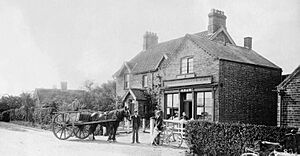
The village's old coaching inn was built in the late 1700s. It was first called The Ship Inn. It had extra horses ready for mail coaches. In 1876, it was renamed The Vanguard. This was to remember the sinking of HMS Vanguard. In 1993, its name changed again to The Coach House. The original coach house building was sold and became a home.
The Keal Cotes Post Office and village shop opened in 1795. It was on the same spot as the village well and a 16th-century farmhouse. The Shaw family ran the shop for many years. In 1923, a telephone box was put outside the post office. Back then, only the post office and the blacksmith had a private phone. The shop and post office closed in 1995. This was partly because new motorways, like the M18 and M180 motorway, made the A16 less busy. The post office moved a couple of times before finally closing in 2005.
A Wesleyan Chapel and Sunday school were built in 1891. It closed in the 1950s and is now used for storage. The village windmill, built in the 1700s, was taken down in 1949. Only the name Mill Lane reminds us it was there.
West Keal Primary School closed in the 1960s. The number of students became too low. Half of the school building was bought by the villages of Keal Cotes and West Keal. It became a community hall, now called the "Craecroft Hall."
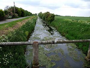
From 1845 to 1930, many people traveled between Keal Cotes and Boston by boat. A daily Steam Packet passenger boat carried people and mail. The Keal Cotes wharf was by the Vanguard Bridge. The boat traveled along the East Fen Catchwater Drain, through Stickford and Sibsey. It then joined the River Trader and went into Boston.
In 1994, the village finally got a main sewer system. However, it still doesn't have a main gas supply. In 2005, a speed limit of 50 miles per hour was set on the A16 road through the village. This happened after 40 years of requests from villagers.
Poor Lands and Community Support
In the past, the parish had special plots of land called Poor Land. The money earned from renting these lands helped the poor people in the parish. This money was given out every year on Lady Day (March 25).
During World War II, some of these lands were taken by the Air Ministry. They became part of RAF East Kirkby, an airfield next to the village. Over time, most of the remaining plots were sold. The money from these sales now forms a fund. The interest from this fund is still given to deserving people in the parish each Christmas.
People who were homeless or very poor in Keal Cotes would go to the Spilsby Poor Law Union Workhouse in Hundleby. In 1870, about 280 people lived there. The workhouse aimed to help the truly needy. It also tried to teach skills and provide education. The workhouse later became Spilsby's Gables Hospital. This hospital was taken down in 2004 to build new homes.
How Keal Cotes is Governed
Understanding how a village is run helps us see how decisions are made.
National Government: Westminster
Keal Cotes is part of the Boston and Skegness Constituency. This means that people in Keal Cotes vote for a Member of Parliament (MP) to represent them in the national government, which is based in Westminster. The current MP for this area is Mark Simmonds from the Conservative Party.
Local Government: Parish Council
Keal Cotes doesn't have its own parish council. Instead, it joins with West Keal to form the West Keal Parish Council. Keal Cotes sends three councillors to this council. These councillors are chosen every four years through elections. The parish council meets once a month at the village hall. They discuss local issues and make decisions for the community.
Keal Cotes' Natural Surroundings: Geography
Keal Cotes is in a special place, surrounded by interesting natural features.
The village is on flat land at the edge of the beautiful Lincolnshire Wolds. The Wolds are low hills with steep valleys. They are made of chalk, green limestone, and sandstone rock. These rocks formed a long time ago under a warm, shallow sea. The valleys were shaped during the last ice age by glaciers and melting ice.
The Lincolnshire Wolds are actually a continuation of the Yorkshire Wolds. The Humber river separates them. To the south of Keal Cotes are the Fenlands. These used to be peat bogs and tidal silt marshes. By the late 1800s, most of them were drained. This created rich, fertile soil perfect for growing crops. This is why Lincolnshire became known as the "bread basket" of England. The flat land also made it easy to use machines for farming later on. The soil in Keal Cotes is a rich brown earth over heavy clay.
The draining of the wetlands created a system of rivers and man-made drains. This helps water flow through the area. Keal Cotes is part of the Witham Fourth District for drainage. The man-made East Fen Catchwater Drain passes near the village. This means that even though the village is low-lying, flooding is very rare.
Who Lives in Keal Cotes: Demography
We don't have separate numbers just for Keal Cotes. The figures from the 2001 census combine Keal Cotes and West Keal. West Keal is a bit larger.
- Total Population: 333 people.
* About 49.8% were male and 50.2% were female.
- Average Age: 43 years old.
- Marital Status:
* 66.2% were married or remarried. * 16.2% were single and had never been married. * The rest were divorced, separated, or widowed.
- Ethnicity:
* 99.1% of the combined population were white European. * 0.9% were Chinese.
- Religion:
* 75.1% were Christians. * 0.9% were Buddhist. * The rest did not state a religion.
What People Do: Economy
The main type of work in Keal Cotes is farming. There aren't many big companies in the area. Most people who work travel to larger towns like Lincoln, Boston, and Skegness.
In recent years, some commercial fishing lakes have opened in the village. One has been there for almost twenty years. The village also has a public house (pub) and a shop. The local blacksmith's workshop closed in the 1990s.
In 1994, the traveling Circus Harlequin moved its winter home to Hagnaby Manor, at the south end of the village. This manor is now called Kasanga Manor. It is home to a large collection of camels, reindeer, and llamas!
Places to See: Landmarks
Keal Cotes and the surrounding area have some interesting places to visit.
- The Coach House: This is the village's public house, with a long history of name changes.
- Keal Cotes Fishing Lake: A place for fishing enthusiasts.
- Keal Cotes Farm Shop: A local shop where you might find fresh produce.
- Bolingbroke Castle - This historic castle is the birthplace of King Henry IV, who was born there on April 3, 1367.
- Gunby Hall - A beautiful stately home run by the National Trust. It's open on certain days in the summer.
- Battle of Britain Memorial Flight at nearby RAF Coningsby - You can see historic planes like an Avro Lancaster bomber, five Supermarine Spitfires, and two Hawker Hurricane fighters.
- Lincolnshire Aviation Heritage Centre - Located in East Kirkby, this museum remembers the RAF's presence in Lincolnshire during World War II. It has one of the world's few remaining Lancaster bombers.
- Spilsby Show: An annual event held in July on the town playing fields. It raises money for local charities.
- Northcote Heavy Horse Centre: A place to see and learn about large working horses.
- Snipedales Nature Reserve and Country Park: A lovely natural area next to the historic Civil War battlefield at Winceby.
Learning in Keal Cotes: Education
There are no schools directly in Keal Cotes.
- Junior Schools: Children from the village attend junior schools in nearby Stickney, Toynton All Saints, and Spilsby.
- Secondary Schools: Older children go to Grammar schools, Comprehensive Schools, or Secondary modern schools in Spilsby, Boston, Skegness, Horncastle, and Stickney. School buses pick up students from the layby outside The Coach House.
Places of Worship: Religious Sites
The main church for Keal Cotes is in West Keal.
The Anglican church in West Keal is named after St Helen. The first church was built in 1186. The current church was built in 1623 using local green sandstone and brick. It has a tall tower with battlements and pinnacles, and it holds six bells.
Part of the church was rebuilt in 1866 because the sandstone had worn away. The church tower fell down on September 18, 1881, but it was quickly rebuilt and finished in 1884. The church clock stopped working in the 1980s but was finally fixed after 2001.
The former Wesleyan Chapel in Keal Cotes is no longer used for religious services and is now closed.
Famous Faces: Notable People
Keal Cotes has been home to a few interesting people.
- Martin Lacey – He is known for breeding tigers in the UK. He provided most of the tigers for the famous Esso TV adverts from the 1950s to the 1990s. He lives in the village.
- Elizabeth Shaw – She was a very old woman, a centenarian. Born on April 22, 1683, she was still living in Keal Cotes in 1800! A portrait of her was published that same year.
 | Janet Taylor Pickett |
 | Synthia Saint James |
 | Howardena Pindell |
 | Faith Ringgold |


