L'Anse Township, Michigan facts for kids
Quick facts for kids
L'Anse Township, Michigan
|
|
|---|---|

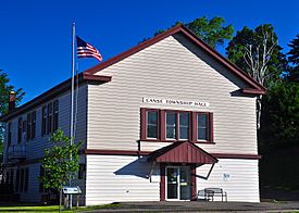
L'Anse Township Hall in the village of L'Anse
|
|

|
|
| Country | |
| State | |
| County | |
| Area | |
| • Total | 269.0 sq mi (696.8 km2) |
| • Land | 247.4 sq mi (640.8 km2) |
| • Water | 21.6 sq mi (56.0 km2) |
| Elevation | 1,365 ft (416 m) |
| Population
(2020)
|
|
| • Total | 3,551 |
| • Density | 16/sq mi (6.0/km2) |
| Time zone | UTC-5 (Eastern (EST)) |
| • Summer (DST) | UTC-4 (EDT) |
| ZIP code |
49946
|
| Area code(s) | 906 |
| FIPS code | 26-45560 |
| GNIS feature ID | 1626587 |
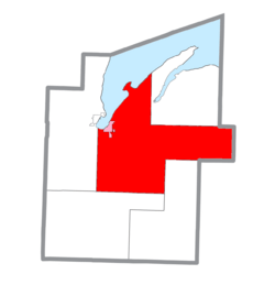
L'Anse Township is a special kind of local government area, like a small town or district, located in Baraga County, in the state of Michigan. In 2020, about 3,551 people lived here. This township is home to some amazing natural features, including Mount Arvon and Mount Curwood, which are the highest and second-highest points in all of Michigan! The village of L'Anse is also part of this township.
Contents
History of L'Anse Township
The story of L'Anse Township began a long time ago. The first European person known to visit this area was a French priest named René Menard. He arrived on October 15, 1660. Father Menard spent the winter in a place now called Pequaming, which is on Keweenaw Bay. He left the following spring and was never seen again. Another priest, Father Claude, came to the area in 1666.
Native American Presence and Early Trading
For the next 200 years, the Chippewa tribe lived in this area. Their presence attracted trappers and traders from all over the Great Lakes region. The American Fur Company set up a trading post in a place called Assinins. The Hudson's Bay Company also had a trading post near Zeba from 1836 for about 15 years. Other early settlers included trappers and missionaries, who were people sent to spread their religious beliefs.
First Missions and Settlements
The first mission in the area was started in 1833 by a Chippewa man named John Sunday. He had become a Christian and was a follower of Methodism. This first mission was located at Zeba, on the east side of the bay. Another mission opened in 1835 at Ottawa Lake. In 1834, Daniel Meeker Chandler traveled by canoe from Sault Ste. Marie. He arrived on September 3 and began mission work for the Methodist Church on the east side of Keweenaw Bay. The next summer, Chandler started cutting wood to build a Native American village, which is known today as Zeba.
Catholic Mission and County Formation
In 1836, a Canadian named Peter Crebassa became the main trader for the American Fur Company. He moved the trading post to a new spot north of L'Anse, where the Township Park is now. Crebassa married a Chippewa woman named Nancy. They played a big part in convincing Father Frederic Baraga to start a Catholic mission. Father Baraga founded this mission at Assinins, on the west side of Keweenaw Bay, in 1843.
When Michigan became the 26th state in 1837, the western part of the Upper Peninsula was included. In 1843, the state government divided the Upper Peninsula into several counties. Three years later, in 1846, the area that is now Keweenaw and Baraga counties became a new county called Houghton. This new county was organized into three election areas, or townships: Eagle Harbor, Houghton, and L'Anse. The area was reorganized again in 1847, and the first election took place in July 1848.
Growth and Rebuilding
The arrival of railroads helped the village of L'Anse grow in 1871. It did well for a few years until a financial crisis called the Panic of 1873. In 1875, Algonquin and L'Anse townships joined together to form Baraga County. This created new townships like Arvon, Baraga, Covington, Spurr, and L'Anse. In 1896, the village of L'Anse was destroyed by fire. However, it slowly rebuilt itself and became a busy lumber town, especially when the Ford Motor Company arrived in the early 1900s.
Geography of L'Anse Township
L'Anse Township covers a large area. According to the United States Census Bureau, its total area is about 696.8 square kilometers (269.0 square miles). Most of this is land, about 640.8 square kilometers (247.4 square miles). The rest, about 56.0 square kilometers (21.6 square miles), is water.
Climate and Weather
The climate in L'Anse Township, specifically near Herman, Michigan, experiences a wide range of temperatures throughout the year. Winters are very cold with lots of snow, while summers are mild to warm.
| Climate data for Herman, Michigan (1991–2020 normals, extremes 1968–present) | |||||||||||||
|---|---|---|---|---|---|---|---|---|---|---|---|---|---|
| Month | Jan | Feb | Mar | Apr | May | Jun | Jul | Aug | Sep | Oct | Nov | Dec | Year |
| Record high °F (°C) | 54 (12) |
61 (16) |
78 (26) |
91 (33) |
93 (34) |
96 (36) |
96 (36) |
95 (35) |
95 (35) |
86 (30) |
73 (23) |
58 (14) |
96 (36) |
| Mean daily maximum °F (°C) | 19.1 (−7.2) |
23.3 (−4.8) |
34.2 (1.2) |
46.7 (8.2) |
62.1 (16.7) |
70.8 (21.6) |
74.8 (23.8) |
72.8 (22.7) |
64.5 (18.1) |
50.4 (10.2) |
35.6 (2.0) |
24.2 (−4.3) |
48.2 (9.0) |
| Daily mean °F (°C) | 12.9 (−10.6) |
15.0 (−9.4) |
24.1 (−4.4) |
36.5 (2.5) |
50.7 (10.4) |
60.0 (15.6) |
64.2 (17.9) |
62.4 (16.9) |
55.1 (12.8) |
42.7 (5.9) |
29.3 (−1.5) |
18.6 (−7.4) |
39.3 (4.1) |
| Mean daily minimum °F (°C) | 6.7 (−14.1) |
6.7 (−14.1) |
14.0 (−10.0) |
26.4 (−3.1) |
39.4 (4.1) |
49.2 (9.6) |
53.5 (11.9) |
52.0 (11.1) |
45.8 (7.7) |
35.0 (1.7) |
23.0 (−5.0) |
13.0 (−10.6) |
30.4 (−0.9) |
| Record low °F (°C) | −36 (−38) |
−40 (−40) |
−35 (−37) |
−17 (−27) |
12 (−11) |
22 (−6) |
26 (−3) |
27 (−3) |
11 (−12) |
1 (−17) |
−18 (−28) |
−37 (−38) |
−40 (−40) |
| Average precipitation inches (mm) | 2.21 (56) |
1.82 (46) |
2.28 (58) |
2.87 (73) |
3.40 (86) |
3.50 (89) |
4.58 (116) |
3.29 (84) |
4.19 (106) |
4.39 (112) |
3.00 (76) |
2.73 (69) |
38.26 (972) |
| Average snowfall inches (cm) | 47.8 (121) |
35.0 (89) |
27.8 (71) |
16.4 (42) |
2.2 (5.6) |
0.0 (0.0) |
0.0 (0.0) |
0.0 (0.0) |
0.2 (0.51) |
8.0 (20) |
28.7 (73) |
41.7 (106) |
207.8 (528) |
| Average precipitation days (≥ 0.01 in) | 18.2 | 13.7 | 12.7 | 12.6 | 13.2 | 12.4 | 13.1 | 12.3 | 14.4 | 16.4 | 16.8 | 17.9 | 173.7 |
| Average snowy days (≥ 0.1 in) | 19.2 | 15.0 | 10.8 | 6.3 | 1.3 | 0.0 | 0.0 | 0.0 | 0.1 | 3.4 | 12.1 | 17.9 | 86.1 |
| Source: NOAA | |||||||||||||
Communities within the Township
The village of L'Anse is the only official town within the township. However, there are several other smaller communities and historic places:
- Alberta is located on U.S. Highway 41, about 8 miles (13 km) south of the village of L'Anse.
- Bovine is a small community along US 41, about 2 miles (3.2 km) south of L'Anse.
- Herman is an area where farming takes place, located near L'Anse.
- Laughs Lake is a community found on Lost Lake within the township.
- Pequaming is on a piece of land that looks like a bear, sticking out into Keweenaw Bay.
- Summit is a place just south of Herman. It used to be a train station around 1880, about 10 miles (16 km) southeast of L'Anse. It got its name because it's close to Mount Curwood. For a long time, people thought Mount Curwood was the highest point in Michigan.
- Zeba is a special area recognized by the census, located just north of the village of L'Anse.
Population of L'Anse Township
According to the 2020 U.S. census, the township had a population of 3,551 people.
See also
 In Spanish: Municipio de L'Anse para niños
 | Kyle Baker |
 | Joseph Yoakum |
 | Laura Wheeler Waring |
 | Henry Ossawa Tanner |


