Lac qui Parle County, Minnesota facts for kids
Quick facts for kids
Lac qui Parle County
|
|
|---|---|

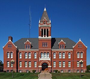
Lac qui Parle County Courthouse
|
|

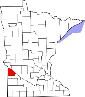
Location within the U.S. state of Minnesota
|
|
 Minnesota's location within the U.S. |
|
| Country | |
| State | |
| Founded | March 6, 1871 |
| Named for | "Lake that speaks" French |
| Seat | Madison |
| Largest city | Dawson |
| Area | |
| • Total | 778 sq mi (2,020 km2) |
| • Land | 765 sq mi (1,980 km2) |
| • Water | 13 sq mi (30 km2) 1.7%% |
| Population
(2020)
|
|
| • Total | 6,719 |
| • Estimate
(2023)
|
6,630 |
| • Density | 8.8/sq mi (3.4/km2) |
| Time zone | UTC−6 (Central) |
| • Summer (DST) | UTC−5 (CDT) |
| Congressional district | 7th |
Lac qui Parle County (/ˌlæk ki ˈpɑːrl/ lak-_-kee-_-parl) is a county in the southwestern part of Minnesota. As of the 2020 census, about 6,719 people lived here. Its county seat (the main government town) is Madison. The biggest city in the county is Dawson.
Contents
History of Lac qui Parle County
The name "Lac qui Parle" comes from French. It means "lake that speaks." This was a translation of the Dakota name, "Mde Lyedan."
How the County Was Formed
In 1862, Minnesota lawmakers wanted to create a county called Lac qui Parle. This area was north of the Minnesota River. But the people living there did not agree, so the county was not formed.
Nine years later, on March 6, 1871, lawmakers tried again. This time, they created the current Lac qui Parle County. It was south of the Minnesota River. Local voters approved it. The first county seat was in Lac qui Parle village.
Moving the County Seat to Madison
In 1884, a new town was planned near a railway stop. This town was named Madison, after Madison, Wisconsin. Madison became an official town in 1885.
In 1889, the county government moved from Lac qui Parle village to Madison. In 1886, people in the county voted for Madison to be the county seat. A fun story says that 150 men and 40 teams of horses helped. They dragged the old town hall building from Lac qui Parle village to Madison!
A new county courthouse was built in Madison in 1899. The Madison City Hall was finished in 1903. Several fires happened in Madison in the early 1900s. Because of this, many wooden buildings were replaced with brick ones.
Health and Population Changes
In March 2011, a study was done by the University of Wisconsin–Madison. It was also supported by the Robert Wood Johnson Foundation. This study named Lac qui Parle County as Minnesota's healthiest county.
The county's population was largest in 1920, with 15,554 people. However, the county seat of Madison kept growing until 1960. At that time, 2,380 people lived there.
Geography of Lac qui Parle County
Lac qui Parle County is on the western side of Minnesota. Its western border touches the state of South Dakota. The Minnesota River flows southeast along the county's northeast edge. It forms Marsh Lake and Lac qui Parle Reservoir.
Rivers and Lakes
The Yellow Bank River adds water to the Minnesota River near the county's north corner. The Lac qui Parle River joins it near the county's east border. The south part of the Yellow Bank River flows north through the west of the county. It meets the north part of the Yellow Bank River. Then, they flow into the Minnesota River. The Lac qui Parle River flows east through the lower part of the county. It joins the Minnesota River near the community of Lac qui Parle.
The county has rolling hills and small bluffs in the west. It has a steep bluff overlooking the Minnesota River valley in the east. Most of the land is used for farming. The land slopes down to the north and east. Its highest point is about 1,404 feet (428 m) above sea level. The county covers 778 square miles (2,015 km²). Of this, 765 square miles (1,981 km²) is land and 13 square miles (34 km²) is water.
Salt Lake is on the county's western border. It is the only alkaline lake in Minnesota. Salt Lake is a great place for bird watching. It has 145 types of birds not found elsewhere nearby. Rare plants and insects also live in this area.
Lakes in the County
- Bolland Slough
- Case Lake
- Flinks Slough (part)
- Kibler Lake
- Lac qui Parle (next to county)
- Marsh Lake (next to county)
- Mud Lake
- Pegg Lake
- Salt Lake (part)
- Swanson Lake
Major Roads in the County
 U.S. Highway 59
 U.S. Highway 75
 U.S. Highway 212
 Minnesota State Highway 40
 Minnesota State Highway 119
Neighboring Counties
- Big Stone County - north
- Swift County - northeast
- Chippewa County - east
- Yellow Medicine County - south
- Deuel County, South Dakota - southwest
- Grant County, South Dakota - northwest
Protected Natural Areas
- Acton Marsh State Wildlife Management Area
- Big Stone National Wildlife Refuge (part)
- Borchardt-Rosin State Wildlife Management Area
- Church State Wildlife Management Area
- De Vorak State Wildlife Management Area
- Flinks State Wildlife Management Area
- Haydenville State Wildlife Management Area
- Kemen State Wildlife Management Area
- Kibler Scientific and Natural Area
- Lac qui Parle State Park
- Medicine Pipe State Wildlife Management Area
- Plantation State Wildlife Management Area
- Providence State Wildlife Management Area
- Sweetwater State Wildlife Management Area
- Wild Wings Baxter State Wildlife Management Area
- Yellow Bank Hills Scientific and Natural Area
People of Lac qui Parle County
| Historical population | |||
|---|---|---|---|
| Census | Pop. | %± | |
| 1870 | 145 | — | |
| 1880 | 4,891 | 3,273.1% | |
| 1890 | 10,382 | 112.3% | |
| 1900 | 14,289 | 37.6% | |
| 1910 | 15,435 | 8.0% | |
| 1920 | 15,554 | 0.8% | |
| 1930 | 15,398 | −1.0% | |
| 1940 | 15,509 | 0.7% | |
| 1950 | 14,545 | −6.2% | |
| 1960 | 13,330 | −8.4% | |
| 1970 | 11,164 | −16.2% | |
| 1980 | 10,592 | −5.1% | |
| 1990 | 8,924 | −15.7% | |
| 2000 | 8,067 | −9.6% | |
| 2010 | 7,259 | −10.0% | |
| 2020 | 6,719 | −7.4% | |
| 2023 (est.) | 6,630 | −8.7% | |
| U.S. Decennial Census 1790-1960 1900-1990 1990-2000 2010-2020 |
|||
The table above shows how the population of Lac qui Parle County has changed over time. The county had its highest population in 1920. Since then, the number of people living here has slowly decreased.
2020 Census Information
The 2020 census collected information about the people living in Lac qui Parle County.
| Race | Number of People | Percentage |
|---|---|---|
| White (not Hispanic) | 6,244 | 93% |
| Black or African American (not Hispanic) | 32 | 0.47% |
| Native American (not Hispanic) | 10 | 0.14% |
| Asian (not Hispanic) | 40 | 0.6% |
| Pacific Islander (not Hispanic) | 0 | 0% |
| Other/Mixed (not Hispanic) | 191 | 2.84% |
| Hispanic or Latino | 202 | 3% |
Most people in Lac qui Parle County are White. There are also smaller groups of Black, Native American, Asian, and people of mixed races. About 3% of the population is Hispanic or Latino.
Communities in Lac qui Parle County
Cities
Unincorporated Communities
These are smaller places that are not officially cities or towns.
Townships
Townships are local government areas, often covering rural land.
- Agassiz Township
- Arena Township
- Augusta Township
- Baxter Township
- Camp Release Township
- Cerro Gordo Township
- Freeland Township
- Garfield Township
- Hamlin Township
- Hantho Township
- Lac qui Parle Township
- Lake Shore Township
- Madison Township
- Manfred Township
- Maxwell Township
- Mehurin Township
- Perry Township
- Providence Township
- Riverside Township
- Ten Mile Lake Township
- Walter Township
- Yellow Bank Township
Extinct Town
- Williamsburg
Education in Lac qui Parle County
Here are the school districts that serve students in Lac qui Parle County:
- Canby Public School District
- Dawson-Boyd Public School District
- Lac qui Parle Valley School District
- Montevideo Public School District
- Ortonville Public Schools
- Yellow Medicine East School District
See also
 In Spanish: Condado de Lac qui Parle para niños
 | Chris Smalls |
 | Fred Hampton |
 | Ralph Abernathy |

