Lake Modoc facts for kids
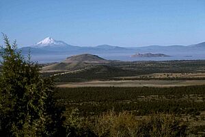
Lake Modoc was a huge ancient lake that once covered parts of what is now California and Oregon. It was located where you can find Upper Klamath Lake, Lower Klamath Lake, and Tule Lake today. This giant lake existed millions of years ago, during the Pliocene and Pleistocene times. Its shape was likely formed by volcanoes and cracks in the Earth's crust (called faults). The land where the lake used to be was rich in resources for early humans, and now it's mostly used for farming.
Contents
Discovering Lake Modoc
Scientists have known for over a hundred years that very large lakes once covered parts of the Western United States. Famous examples include Lake Lahontan in Nevada and Lake Bonneville in Utah. Similar ancient lakes also formed in eastern Oregon. Today, Malheur Lake and Goose Lake are small parts of these much larger old lakes.
Lake Modoc got its name from Samuel N. Dicken, a geography professor at the University of Oregon. People first explored and described the area where Lake Modoc once was in the early and mid-1800s.
What Lake Modoc Was Like
Lake Modoc was a type of lake called a "pluvial lake." This means it formed during a time when the climate was much wetter, usually during ice ages. Its basin, or the bowl-shaped area it filled, was created by movements in the Earth's crust (faulting) and volcanic activity.
The lake stretched for about 120 kilometres (75 mi) (about 75 miles). It went from south of Tule Lake in California all the way to near Fort Klamath in Oregon. Its waters reached about 1,292 metres (4,239 ft) (4,239 feet) above sea level. Lake Modoc covered a huge area of about 2,839 square kilometres (1,096 sq mi) (1,096 square miles). It had a very uneven shape, with many bays and peninsulas.
Several islands poked out of the lake's surface. These included the Klamath Hills, Miller Hill (near Klamath Falls today), and Turkey Hill (near Malin today). You can still see the old shoreline of Lake Modoc very clearly near Tule Lake.
How Water Flowed In and Out
Unlike many other ancient lakes that relied only on rain and snowmelt, Lake Modoc had a steady supply of water. This was because it was close to the Cascade Range, a mountain range with lots of snow and glaciers.
The area that fed water into Lake Modoc was very large. It included parts of Modoc and Siskiyou counties in California. It also covered parts of Jackson, Klamath, and Lake counties in Oregon. Rivers like the Williamson River, Sprague River, and Lost River all flowed into Lake Modoc.
Over time, volcanic materials like cinder, pumice, and volcanic ash from the Cascade Mountains filled parts of the lake.
Lake Modoc also had a way for water to flow out. At first, water drained to the south. However, a lava flow later blocked this exit. Even after the lava blocked it, some water continued to seep out from that area. Today, the Klamath River drains this region. Because the area can't hold such a large lake now, scientists believe the lake's formation and disappearance were affected by how its water flowed in and out.
The Lake's History
Lake Modoc likely formed due to big changes in the Earth. This included faulting (when parts of the Earth's crust move) or when the Medicine Lake Volcano blocked an old river path that flowed south. Scientists believe the lake existed during the Pleistocene and late Pliocene periods. Some of the lake's deposits are thought to be at least 3 million years old. During one cold period (called marine oxygen isotope stage 4), Lake Modoc was very deep and cold.
As the Pleistocene period ended, the climate became drier. The water levels in Lake Modoc began to drop. Also, the outlet to the Klamath River became lower, allowing more water to drain away.
Today, the old lake floor is mostly flat. You can still see the old shoreline, which has not changed much. Tule Lake, Upper Klamath Lake, and Lower Klamath Lake are all that remain of the once-giant Lake Modoc. Upper Klamath Lake is now the largest lake in Oregon by surface area.
Early Humans and Farming
When Lake Modoc dried up, it left behind rich soils. This land had plenty of plants, water, and wildlife. Because of these resources, humans quickly moved into the area. People began living there over 3,000 years ago.
Today, the former lakebed is mostly used as cropland. Farming is now the most important way humans use the land in this region. Some parts of the southern shoreline have been covered by lava flows. Even in recent times (the Holocene period), geological processes have continued. For example, the Glass Mountain lava flow happened about 1,000 years ago. Some lava flows from the Holocene have even been affected by faulting.
 | Calvin Brent |
 | Walter T. Bailey |
 | Martha Cassell Thompson |
 | Alberta Jeannette Cassell |


