Le Sueur County, Minnesota facts for kids
Quick facts for kids
Le Sueur County
|
|
|---|---|

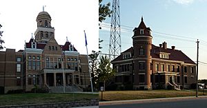
Le Sueur County Courthouse and Jail
|
|

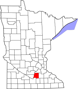
Location within the U.S. state of Minnesota
|
|
 Minnesota's location within the U.S. |
|
| Country | |
| State | |
| Founded | March 5, 1853 |
| Named for | Pierre-Charles Le Sueur |
| Seat | Le Center |
| Largest city | Le Sueur |
| Area | |
| • Total | 474 sq mi (1,230 km2) |
| • Land | 449 sq mi (1,160 km2) |
| • Water | 25 sq mi (60 km2) 5.3%% |
| Population
(2020)
|
|
| • Total | 28,674 |
| • Estimate
(2023)
|
29,255 |
| • Density | 63.9/sq mi (24.7/km2) |
| Time zone | UTC−6 (Central) |
| • Summer (DST) | UTC−5 (CDT) |
| Congressional district | 1st |
Le Sueur County is a county located in the south-central part of Minnesota, a state in the United States. In 2020, about 28,674 people lived here. The main town, or county seat, is Le Center. Le Sueur County is also part of the larger Minneapolis-St. Paul area.
Contents
History of Le Sueur County
How Le Sueur County Was Formed
Le Sueur County was created on March 5, 1853. This happened when the Minnesota Territory legislature decided to establish several new counties. The county was named after Pierre-Charles Le Sueur. He was a French explorer who visited this area around the year 1700.
Choosing the County Seat
The first county seat was the settlement of Le Sueur. This town was actually two smaller towns, Le Sueur and Le Sueur City, that grew up together. They were located on the east bank of the Minnesota River.
However, Le Sueur was far away from many parts of the county. The area was covered in thick forests, and the roads were often muddy and hard to use. This made it difficult for people to reach the county seat.
Moving the County Seat
People wanted a county seat that was more central. In the early 1870s, the town of Cleveland tried to become the county seat. A vote was held, and Cleveland won. But there were problems with the voting, so the change didn't last long.
In 1875, another vote made Cleveland the county seat for a short time. Then, in 1876, a new town called Le Sueur Center was created. Business people bought land near the center of the county, cleared the trees, and planned out the new town. Another vote approved moving the county seat to Le Sueur Center.
The county seat has stayed in Le Sueur Center ever since 1876. In 1930, the town's name was changed to Le Center.
New Transportation and Buildings
The first railroad arrived in Le Sueur County in 1867. This made it much easier for people and goods to travel. The first building specifically built as a courthouse in Le Sueur Center was finished in 1897. It has been updated and made larger two times since then.
Geography of Le Sueur County
Rivers and Land
The Minnesota River flows along the western edge of Le Sueur County. It eventually joins the Mississippi River. The land here has gentle, rolling hills and many lakes and ponds. The soil is very rich and dark. The land generally slopes towards the north and east. The highest point in the county is about 1,145 feet (349 meters) above sea level.
Le Sueur County covers about 474 square miles (1,228 square kilometers). Of this, 449 square miles (1,163 square kilometers) is land, and 25 square miles (65 square kilometers) is water. This means about 5.3% of the county is water. Le Sueur is one of the few counties in Minnesota where savanna soils are common.
Lakes in Le Sueur County
Many lakes are found partly or entirely within Le Sueur County. Some of these include:
- Borer Lake
- Bossuot Lake
- Clear Lake
- Decker Lake
- Diamond Lake
- Dietz Lake
- Dog Lake
- Dora Lake
- Eggert Lake
- Ely Lake
- Emily Lake
- Fish Lake
- German Lake
- Goldsmith Lake
- Goose Lake (Cordova Township)
- Goose Lake (Waterville Township)
- Gorman Lake
- Greenleaf Lake
- Harkridge Lake
- Horseshoe Lake (part)
- Huoy Lake
- Lake Emily
- Lake Francis
- Lake Henry
- Lake Jefferson
- Lake Mabel
- Lake Pepin
- Lake Sanborn
- Lake Tustin
- Lake Volney
- Lake Washington
- Mareks Lake
- Mary Lake
- Mud Lake (Cordova Township)
- Mud Lake (Lanesburgh Township)
- Mud Lake (Lexington Township)
- North Goldsmith Lake
- Perch Lake
- Rays Lake
- Rice Lake
- Roemhildts Lake
- Round Lake
- Sabre Lake
- Sakatah Lake (part)
- Sanborn Lake
- Sasse Lake
- Savidge Lake
- School Lake
- Scotch Lake
- Shanghai Lake
- Sheas Lake
- Silver Lake (Cleveland Township)
- Silver Lake (Elysian Township)
- Sleepy Eye Lake
- Steele Lake
- Sunfish Lake
- Tetonka Lake (headwaters of Cannon River)
- Thomas Lake
- Tyler Lake
Protected Natural Areas
Le Sueur County is home to several protected natural areas, which help preserve wildlife and nature. These include:
- Bardel State Wildlife Management Area
- Chadderdon State Wildlife Management Area
- Chamberlain Woods Scientific and Natural Area
- Diamond Lake State Wildlife Management Area
- Minnesota Valley National Wildlife Refuge (part)
- Ottawa State Wildlife Management Area
- Paddy Marsh State Wildlife Management Area
- Saint Thomas State Wildlife Management Area
- Sakatah Lake State Park (part)
- Seven Mile Creek State Park (part)
- Shanghai State Wildlife Area
- Sheas Lake State Wildlife Area
Main Roads in Le Sueur County
These are some of the major highways that pass through Le Sueur County:
Neighboring Counties
Le Sueur County shares borders with these other counties:
- Scott County - north
- Rice County - east
- Waseca County - south
- Blue Earth County - southwest
- Nicollet County - west
- Sibley County - northwest
Population of Le Sueur County
How the Population Has Changed
The number of people living in Le Sueur County has changed over many years. Here's a look at the population from different censuses:
| Historical population | |||
|---|---|---|---|
| Census | Pop. | %± | |
| 1860 | 5,318 | — | |
| 1870 | 11,607 | 118.3% | |
| 1880 | 16,303 | 40.5% | |
| 1890 | 19,057 | 16.9% | |
| 1900 | 20,234 | 6.2% | |
| 1910 | 18,609 | −8.0% | |
| 1920 | 17,870 | −4.0% | |
| 1930 | 17,990 | 0.7% | |
| 1940 | 19,227 | 6.9% | |
| 1950 | 19,088 | −0.7% | |
| 1960 | 19,906 | 4.3% | |
| 1970 | 21,331 | 7.2% | |
| 1980 | 23,434 | 9.9% | |
| 1990 | 23,929 | 2.1% | |
| 2000 | 25,426 | 6.3% | |
| 2010 | 27,703 | 9.0% | |
| 2020 | 28,674 | 3.5% | |
| 2023 (est.) | 29,255 | 5.6% | |
| U.S. Decennial Census 1790-1960 1900-1990 1990-2000 2010-2020 |
|||
Population Makeup in 2020
The 2020 census showed the different groups of people living in Le Sueur County.
| Race | Number of People | Percentage |
|---|---|---|
| White (not Hispanic) | 25,463 | 88.8% |
| Black or African American (not Hispanic) | 262 | 0.9% |
| Native American (not Hispanic) | 67 | 0.2% |
| Asian (not Hispanic) | 134 | 0.4% |
| Pacific Islander (not Hispanic) | 20 | 0.06% |
| Other/Mixed (not Hispanic) | 856 | 3% |
| Hispanic or Latino | 1,872 | 6.5% |
Communities in Le Sueur County
Cities in the County
- Cleveland
- Elysian (partly in another county)
- Heidelberg
- Kasota
- Le Center (the county seat)
- Le Sueur (partly in another county)
- Kilkenny
- Mankato (partly in another county)
- Montgomery
- New Prague (partly in another county)
- Waterville
Smaller Unincorporated Communities
These are smaller places that are not officially cities:
- Cordova
- Greenland
- Henderson Station
- Lexington
- Marysburg (partly in another county)
- Ottawa
- St. Henry
- St. Thomas
- Union Hill (partly in another county)
Former Communities
- Okaman
Townships in Le Sueur County
Townships are smaller local government areas within the county:
- Cleveland Township
- Cordova Township
- Derrynane Township
- Elysian Township
- Kasota Township
- Kilkenny Township
- Lanesburgh Township
- Lexington Township
- Montgomery Township
- Ottawa Township
- Sharon Township
- Tyrone Township
- Washington Township
- Waterville Township
See also
 In Spanish: Condado de Le Sueur para niños
 | William Lucy |
 | Charles Hayes |
 | Cleveland Robinson |

