List of locks and dams of the Ohio River facts for kids
A list of locks and dams on the Ohio River helps boats travel smoothly. The Ohio River starts where the Allegheny River and Monongahela River meet in Pittsburgh, Pennsylvania. It flows all the way to Cairo, Illinois, where it joins the Mississippi River.
Contents
Long ago, when steamboats first traveled the Ohio River, there was a big problem: the Falls of the Ohio near Louisville, Kentucky. These "falls" were actually rocky rapids. Boats could only get past them when the water was very high. This wasn't often!
So, steamboats would drop off people and goods on one side of the falls. Then, everything would be moved over land to another steamboat waiting on the other side. This made Louisville a busy stop for all river travel. To make travel easier, a special canal with locks was needed to go around the falls.
In 1825, work began on this canal. By 1830, the Louisville and Portland Canal was finished. Workers built it using hand tools and carts pulled by animals. The canal was two miles long and had three special "locking chambers." These chambers lifted or lowered boats a total of 26 feet.
Building More Locks and Dams
After the American Civil War, a lot more coal was shipped down the river from Pittsburgh. The boats carrying the coal, called "tows," also became much bigger. Because of this growing coal trade, the US Army Corps of Engineers started looking for ways to make the Ohio River deep enough for boats all the time.
They studied navigation projects around the world. They found that building a system of locks and dams was the best way. These structures create calm, deep sections of water called "pools."
The first lock and dam opened at Davis Island in 1885. It worked very well! In 1910, the U.S. Congress approved a plan to build a whole system of locks and dams along the Ohio River. By 1929, this big project was finished. It included 51 wooden dams and 600-foot long by 110-foot wide lock chambers.
In the 1940s, boats started using diesel engines instead of steam. These new towboats could push even longer groups of barges. But the 600-foot locks were too short! This meant barges had to go through the locks in two parts. This was slow and sometimes dangerous. It caused traffic jams and cost more money for shipping companies.
So, in the 1950s, the Corps of Engineers started a new plan. They wanted to replace the old dams and small locks with bigger, stronger ones made of concrete and steel. Each new dam has two locks: one 600-foot by 110-foot chamber and a much larger 1,200-foot by 110-foot chamber. This bigger lock can fit up to fifteen barges at once, making river travel much faster!
Key to the Table
Dam produces hydroelectricity (power from water).
This lock/dam has been replaced with a new one.
This lock/dam is currently being replaced.
This lock/dam has been removed.
| RDB | Right Descending Bank (looking downstream) |
| LDB | Left Descending Bank (looking downstream) |
Locks and Dams Downstream from Pittsburgh to Olmsted
| Locks & Dam | Location | Coordinates | River Mile | Lock Side | Lock Lift/Drop (in feet) |
Pool Elevation (feet above sea level) |
Pool Length (miles) |
|---|---|---|---|---|---|---|---|
Pennsylvania |
|||||||
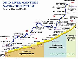
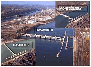
| Emsworth Locks and Dam | Pittsburgh, Pennsylvania | 40°30′15″N 80°05′20″W / 40.50427°N 80.08892°W | 6.2 | RDB | 18 | 710 | 6.2+ |
| Dashields Locks and Dam | Coraopolis, Pennsylvania | 40°32′56″N 80°12′21″W / 40.54892°N 80.20592°W | 13.3 | LDB | 10 | 692 | 7.1 |
| Montgomery Locks and Dam | Monaca, Pennsylvania | 40°38′55″N 80°23′08″W / 40.64857°N 80.38546°W | 31.7 | LDB | 18 | 682 | 18.4 |
Ohio – West Virginia |
|||||||
| New Cumberland Locks and Dam | Stratton, Ohio | 40°31′40″N 80°37′39″W / 40.52766°N 80.62763°W | 54.3 | RDB | 21 | 664 | 22.6 |
| Pike Island Locks and Dam | Wheeling, West Virginia | 40°08′59″N 80°42′04″W / 40.14983°N 80.70115°W | 84.2 | LDB | 21 | 644 | 29.9 |
| Hannibal Locks and Dam | Hannibal, Ohio | 39°40′01″N 80°51′55″W / 39.66706°N 80.86534°W | 126.4 | RDB | 21 | 623 | 42.2 |
| Willow Island Lock and Dam | Newport, Ohio | 39°21′38″N 81°19′13″W / 39.36048°N 81.32041°W | 161.7 | RDB | 20 | 602 | 35.3 |
| Belleville Lock and Dam | Reedsville, Ohio | 39°07′08″N 81°44′33″W / 39.11881°N 81.74244°W | 203.9 | RDB | 22 | 582 | 42.2 |
| Racine Lock and Dam | Letart, West Virginia | 38°55′02″N 81°54′42″W / 38.91735°N 81.91162°W | 237.5 | LDB | 22 | 560 | 33.6 |
| Robert C. Byrd Lock and Dam | Gallipolis Ferry, West Virginia | 38°40′54″N 82°11′18″W / 38.68156°N 82.18829°W | 279.2 | LDB | 23 | 538 | 41.7 |
Ohio – Kentucky |
|||||||
| Greenup Lock and Dam | Greenup, Kentucky | 38°38′49″N 82°51′39″W / 38.64684°N 82.86077°W | 341.0 | LDB | 30 | 515 | 61.8 |
| Captain Anthony Meldahl Locks and Dam | Foster, Kentucky | 38°47′50″N 84°10′14″W / 38.79720°N 84.17050°W | 436.2 | RDB | 30 | 485 | 95.2 |
Indiana – Kentucky |
|||||||
| Markland Locks and Dam | Warsaw, Kentucky | 38°46′28″N 84°57′54″W / 38.77446°N 84.96487°W | 531.5 | LDB | 35 | 455 | 95.3 |
| McAlpine Locks and Dam | Louisville, Kentucky | 38°16′58″N 85°46′53″W / 38.28280°N 85.78130°W | 606.8 | LDB | 37 | 420 | 75.3 |
| Cannelton Locks and Dam | Cannelton, Indiana | 37°54′00″N 86°42′21″W / 37.89990°N 86.70590°W | 720.7 | RDB | 25 | 383 | 113.9 |
| Newburgh Lock and Dam | Newburgh, Indiana | 37°55′51″N 87°22′20″W / 37.93090°N 87.37220°W | 776.1 | RDB | 16 | 358 | 55.4 |
| John T. Myers Locks and Dam | Mt. Vernon, Indiana | 37°47′37″N 87°59′27″W / 37.79350°N 87.99090°W | 846.0 | RDB | 18 | 342 | 69.9 |
Illinois – Kentucky |
|||||||
| Smithland Lock and Dam | Hamletsburg, Illinois | 37°09′56″N 88°25′51″W / 37.16560°N 88.43090°W | 918.5 | RDB | 22 | 324 | 72.5 |
| Lock and Dam Number 52 (Removed) | Brookport, Illinois | 37°07′35″N 88°39′12″W / 37.12644°N 88.65331°W | 938.9 | RDB | 12 | 302 | 20.4 |
| Lock and Dam Number 53 (Removed) | Grand Chain, Illinois | 37°12′12″N 89°02′31″W / 37.203398°N 89.041941°W | 962 | RDB | ≤17 | 290 | 23.7 |
| Olmsted Locks and Dam (Replaced 52 and 53) | Olmsted, Illinois | 37°11′02″N 89°03′49″W / 37.18380°N 89.06350°W | 964.4 | RDB | ≤30 | -- | 46.0 |
See also
- List of crossings of the Ohio River
- List of locks and dams of the Upper Mississippi River
- United States Army Corps of Engineers
 | Laphonza Butler |
 | Daisy Bates |
 | Elizabeth Piper Ensley |


