
List of locks and dams of the Upper Mississippi River facts for kids
-
This transport-related list is incomplete; you can help by expanding it.


The Upper Mississippi River is a very long and important river in the United States. To help boats travel safely and manage water levels, many special structures called locks and dams have been built along its path. These structures are like giant water elevators that lift or lower boats from one part of the river to another. They also create calm pools of water, making it easier for boats to move and helping to prevent floods.
This article lists the main locks and dams on the Upper Mississippi River, from its start in Minnesota all the way down to where it meets the Ohio River in Cairo, Illinois.
Contents
What are Locks and Dams?
Locks and dams are engineering marvels that help control the flow of water in a river. A dam is a barrier built across a river to hold back water, creating a deeper, calmer section called a "pool." This helps keep the river deep enough for boats to travel, even during dry seasons.
A lock is a chamber with gates at both ends. When a boat wants to move from one water level to another, it enters the lock. Water is then either added to the chamber to raise the boat or removed to lower it. This allows boats to bypass the dam and continue their journey up or down the river.
Most of the locks and dams on the Upper Mississippi River are managed by the United States Army Corps of Engineers, which is a part of the U.S. Army that builds and manages public works projects.
Locks and Dams of the Upper Mississippi
Here is a list of the locks and dams you can find along the Upper Mississippi River. They are listed from north to south, starting in Minnesota.
| Name | Location | Notes |
|---|---|---|
Minnesota |
||
| Lake Itasca Stepping Stones / Dam | Itasca State Park | These are stepping stones placed by the Civilian Conservation Corps (CCC) to create a new path for the Mississippi River. |
| Vekin's Dam | 8 miles north of Lake Itasca | This is an old wooden dam from the late 1800s. |
| Ottertail Power Co. Dam | 7 miles east of Bemidji | This dam helps manage the water level of Lake Bemidji. |
| Knutson Dam | About 15 km east and north of Cass Lake | This dam helps manage the water level of Cass Lake. |
| Winnibigoshish Lake Dam | About 15 km northwest of Deer River | This dam is managed by the U.S. Army Corps of Engineers. |
| Pokegama Dam | Mile 1187 | This dam is also managed by the U.S. Army Corps of Engineers. |
| Blandin Paper Co. Dam | Mile 1183.6 | |
| Potlatch Dam | Brainerd, Minnesota | This dam helps manage the water level of Rice Lake. |
| Little Falls Dam | Little Falls, Minnesota | |
| Blanchard Dam | Royalton, Minnesota | |
| Sartell Dam | Sartell, Minnesota | |
| St. Cloud Dam | St. Cloud, Minnesota | |
| Coon Rapids Dam | Brooklyn Park / Coon Rapids, Minnesota | This dam does not have a lock, meaning boats cannot pass through it. It marks the end of the river section that boats can travel on (the navigable portion). |
| Upper Saint Anthony Falls Lock and Dam | Minneapolis, Minnesota | This is the last lock upstream on the river. Since June 9, 2015, it has been closed to stop the spread of invasive Asian Carp fish. It's located in the Mississippi National River and Recreation Area. |
| Lower Saint Anthony Falls Lock and Dam | Minneapolis, Minnesota | This lock is managed by the U.S. Army Corps of Engineers. |
| Meeker Island Lock and Dam (demolished) |
Minneapolis, Minnesota / St. Paul, Minnesota | This lock and dam was taken down. It was originally known as Lock and Dam No. 2. |
| Lock and Dam No. 1 | Minneapolis, Minnesota / St. Paul, Minnesota | There is a power plant on the east side of this lock. It is managed by the U.S. Army Corps of Engineers. |
| Lock and Dam No. 2 | Hastings, Minnesota | This lock is managed by the U.S. Army Corps of Engineers. |
Minnesota–Wisconsin |
||
| Lock and Dam No. 3 | Red Wing, Minnesota | This lock is managed by the U.S. Army Corps of Engineers. |
| Lock and Dam No. 4 | Alma, Wisconsin | The lock is on the Wisconsin side, near a small cafe. It is managed by the U.S. Army Corps of Engineers. |
| Lock and Dam No. 5 | Winona County, Minnesota | Visitors can park next to this lock. It is managed by the U.S. Army Corps of Engineers. |
| Lock and Dam No. 5A | Goodview, Minnesota | This lock is managed by the U.S. Army Corps of Engineers. |
| Lock and Dam No. 6 | Trempealeau, Wisconsin | This lock is managed by the U.S. Army Corps of Engineers. |
| Lock and Dam No. 7 | La Crescent, Minnesota | This lock is next to the I-90 Mississippi River Bridge. There is visitor parking and information nearby. It is managed by the U.S. Army Corps of Engineers. |
| Lock and Dam No. 8 | Genoa, Wisconsin | Visitors can park right next to this lock. It is managed by the U.S. Army Corps of Engineers. |
Iowa–Wisconsin |
||
| Lock and Dam No. 9 | Harpers Ferry, Iowa | There is a parking area next to the lock on the Wisconsin side. It is managed by the U.S. Army Corps of Engineers. |
| Lock and Dam No. 10 | Guttenberg, Iowa | This lock is managed by the U.S. Army Corps of Engineers. |
| Lock and Dam No. 11 | Dubuque, Iowa | This lock is managed by the U.S. Army Corps of Engineers. |
Iowa–Illinois |
||
| Lock and Dam No. 12 | Bellevue, Iowa | This lock is managed by the U.S. Army Corps of Engineers. |
| Lock and Dam No. 13 | Fulton, IL | This lock is managed by the U.S. Army Corps of Engineers. |
| Lock and Dam No. 14 | LeClaire, Iowa | This lock is managed by the U.S. Army Corps of Engineers. |
| Lock and Dam No. 15 | Rock Island, Illinois | This lock is managed by the U.S. Army Corps of Engineers. |
| Lock and Dam No. 16 | Muscatine, Iowa | This lock is managed by the U.S. Army Corps of Engineers. |
| Lock and Dam No. 17 | New Boston, Illinois | This lock is managed by the U.S. Army Corps of Engineers. |
| Lock and Dam No. 18 | Gladstone, Illinois | This lock is managed by the U.S. Army Corps of Engineers. |
| Lock and Dam No. 19 | Keokuk, Iowa | This lock is managed by the U.S. Army Corps of Engineers. |
Missouri–Illinois |
||
| Lock and Dam No. 20 | Canton, Missouri | This lock is managed by the U.S. Army Corps of Engineers. |
| Lock and Dam No. 21 | Quincy, Illinois | This lock is managed by the U.S. Army Corps of Engineers. |
| Lock and Dam No. 22 | Saverton, Missouri | This lock is managed by the U.S. Army Corps of Engineers. |
| Lock and Dam No. 24 | Clarksville, Missouri | This lock is managed by the U.S. Army Corps of Engineers. |
| Lock and Dam No. 25 | Winfield, Missouri | This lock is managed by the U.S. Army Corps of Engineers. |
| Lock and Dam No. 26 (historical) | Alton, Illinois | This lock and dam was taken down and replaced by the Melvin Price Locks and Dam. |
| Melvin Price Locks and Dam aka Lock and Dam No. 26 |
East Alton, Illinois | This modern lock and dam is managed by the U.S. Army Corps of Engineers. |
| Chain of Rocks Dam aka Dam No. 27 |
Glasgow Village, Missouri | This dam is managed by the U.S. Army Corps of Engineers. |
| Chain of Rocks Lock aka Lock No. 27 |
Granite City, Illinois | This lock is managed by the U.S. Army Corps of Engineers. |
Future Plans for Locks
The U.S. Army Corps of Engineers has been looking into making some of the locks on the Upper Mississippi River bigger. Since at least 1999, they have thought about making five locks (Numbers 20, 21, 22, 24, and 25) much longer. This would help bigger boats and more barges move through the river more easily and quickly.
Images for kids
-
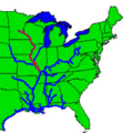
This map shows the inland and intercoastal waterways, with the Upper Mississippi highlighted in red.
-
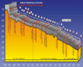
A diagram showing the "Stairway of Water" on the Upper Mississippi River, illustrating how locks and dams create different water levels.
-
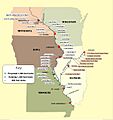
A map used in a study about expanding the Upper Mississippi locks.


See also
- List of crossings of the Upper Mississippi River
- Mississippi Valley Division
- List of locks and dams of the Ohio River
