
List of scheduled monuments in Cheshire (1066–1539) facts for kids

Cheshire, a county in North West England, is home to over two hundred special historical sites called scheduled monuments. These sites range from ancient times, like the Neolithic period, all the way up to the mid-20th century. This list focuses on the scheduled monuments in Cheshire from the medieval period, which was between the years 1066 and 1539.
A scheduled monument is a nationally important archaeological site or monument that gets legal protection. It's put on a special list by the Secretary of State for Culture, Media and Sport. English Heritage helps find these important places. The word "monument" can mean all sorts of archaeological sites, and they aren't always visible above ground. These sites had to be built on purpose by people. They include everything from prehistoric standing stones and burial sites, to Roman ruins, and medieval structures like castles and monasteries. Later sites, such as industrial buildings or structures from the World Wars, are also protected.
Contents
Discovering Cheshire's Medieval Treasures
More than half of Cheshire's scheduled monuments, at least 129 of them, are from the medieval period. The most common type of monument you'll find are moats or moated sites, with 55 of them. Next are the remains of crosses, with 15 found in churchyards and 11 by the roadside. There are also the remains of 12 castles.
You can also find seven deserted villages, three boundary stones, and the remains of three abbeys. There are two holy wells and two old halls. Other unique finds include a lime kiln, a pottery kiln, a hospital, a former chapel, a monastic grange, a tomb, an ice house, and a hunting lodge. Some scheduled monuments, like the Chester city walls, the Dee Bridge, and Farndon Bridge, are still largely complete and used today!
Why Were These Medieval Sites Built?
During the medieval period, people built houses on moated sites not just for defense, but also to show off how important they were. Cheshire has over 200 moated sites, out of more than 6,000 in England.
Crosses in churchyards were used for many things. People would pray there, go on pilgrimages, or gather for public announcements. Many crosses were destroyed after the Reformation. Some were even turned into sundials by Catholics who wanted to protect them from being completely ruined. Other standing stones were part of wayside crosses, which helped guide people to local abbeys. Some were "plague stones," used to exchange money and goods safely during times of plague.
Motte and bailey castles were brought to Britain by the Normans. In Cheshire, they helped protect the area's farms and food supplies. Often, these monuments are just earthworks or foundations. If there are still big parts of the original buildings, they are often also listed as special historic buildings.
Cheshire's Medieval Scheduled Monuments (1066-1539)
Here's a list of some of the medieval scheduled monuments you can find in Cheshire:
| Name | What's Left | Location | When it's From | What it is |
|---|---|---|---|---|
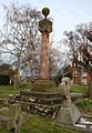
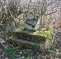
| Acton churchyard cross | Stone structure | Acton 53°04′25″N 2°33′05″W / 53.0736°N 2.5513°W |
Medieval | Part of a cross with an eight-sided base on three steps. In the late 1600s, it was turned into a sundial. |
| Alderhedge Wood moat | Moat | Near Arley 53°19′03″N 2°28′29″W / 53.3174°N 2.4748°W |
Medieval | A rectangular moat, about 54m by 55m, filled with water. It also has a fishpond and a channel connecting them. |
| Aldford Castle | Earthworks | Aldford 53°07′49″N 2°52′11″W / 53.1304°N 2.8698°W |
12th century | This was once a motte and bailey castle, likely built in the 1100s. Only earth mounds and dry ditches remain today. |
| Ashton pottery kiln | Excavation site | Ashton Hayes 53°13′01″N 2°44′25″W / 53.2169°N 2.7404°W |
13th century | A potter's oven found in 1933 with pieces of pottery from the 1200s to 1400s. Nothing is visible on the surface now. |
| Astbury churchyard cross | Stone structure | Newbold Astbury 53°09′03″N 2°13′54″W / 53.1508°N 2.2316°W |
Medieval | The base of a cross, made of eight-sided stone, on two steps. A sundial was added later. |
| Baddiley village | Earthworks | Baddiley 53°02′59″N 2°35′11″W / 53.0497°N 2.5863°W |
Late Saxon and medieval | A village that was abandoned. You can see signs of at least nine houses and barns. |
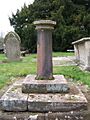
| Barrow churchyard cross | Standing stone | Barrow 53°12′33″N 2°47′45″W / 53.2093°N 2.7959°W |
Early 15th century | The remains of a cross with a square base and a tapering shaft. It was turned into a sundial. |
| Barrow Old Hall moated site | Earthwork | Great Sankey 53°24′05″N 2°39′38″W / 53.4013°N 2.6605°W |
Medieval | This site once had a timber framed house from at least 1330. Now it's an empty platform surrounded by a moat. |
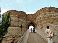
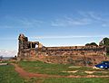
| Beeston Castle | Castle ruins | Beeston 53°07′41″N 2°41′31″W / 53.1280°N 2.6919°W |
1220 and later | A medieval castle built on an older hillfort. It was involved in the Civil War but became a ruin by the 1500s. |
| Belgrave moated site | Earthworks | Eaton 53°08′18″N 2°54′45″W / 53.1384°N 2.9126°W |
Medieval | Once a manor house with a moat and a medieval garden. By the 1600s, it became part of the Eaton estate. |
| Belmont moat | Moat | Great Budworth 53°18′06″N 2°30′57″W / 53.3016°N 2.5159°W |
Medieval | This was once a grange (a farm owned by a monastery). Now it's a water-filled moat around a five-sided platform. |
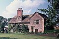
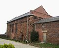
| Bewsey Old Hall moated site | Moat, fishpond and building platform | Burtonwood 53°24′05″N 2°37′02″W / 53.4014°N 2.6171°W |
Medieval | Originally a farm, then a moated manor house. The moat, fishpond, and building platform are protected. |
| Bostock Hall moat | Earthworks | Winsford 53°12′07″N 2°29′10″W / 53.2020°N 2.4862°W |
Medieval | A rectangular moat, often waterlogged, with an overgrown platform and a path. |
| Bradlegh Old Hall moated site | Moated site, gatehouse and fishpond | Burtonwood 53°26′24″N 2°38′47″W / 53.4399°N 2.6463°W |
Medieval | A moated hall from the 1400s. The moat, a fortified gatehouse, and a fishpond are still there. |
| Bradley Green | Earthworks | Bradley 53°00′31″N 2°44′19″W / 53.0086°N 2.7386°W |
Medieval | A medieval village that is now deserted. Photos from above show small house platforms and an old road. |
| Bradley Hall moated site | Earthworks | Appleton, Warrington 53°21′23″N 2°31′00″W / 53.3565°N 2.5166°W |
Medieval | Once a moated manor house. A more modern farmhouse and garden now sit on most of the platform. |
| Bruera churchyard cross | Stone structure | Bruera 53°08′21″N 2°50′31″W / 53.1392°N 2.8419°W |
Medieval | The base and part of the shaft of an old cross, later turned into a sundial in the churchyard. |
| Bruera moat and field system | Earthworks | Buerton 53°08′22″N 2°50′33″W / 53.1395°N 2.8425°W |
Medieval | A former moated manor house surrounded by smaller fenced areas that formed a field system. |
| Capesthorne Hall and chapel | Earthworks | Siddington 53°14′59″N 2°14′12″W / 53.2497°N 2.2367°W |
Medieval | The platform of an old chapel is marked by a memorial. Earthworks from the old hall are nearby. |
| Castle Cob motte | Earthworks | Manley 53°15′21″N 2°41′59″W / 53.2558°N 2.6998°W |
Medieval | A steep-sided mound (motte) about 23m wide and 2.8m high, with no signs of a bailey (walled area). |
| Castle Hill | Earthworks | Malpas 53°01′12″N 2°46′02″W / 53.0200°N 2.7672°W |
Medieval | A mound that once held the main tower of the Malpas Barons' castle. No signs of a bailey or ditch. |
| Castle Hill system | Earthworks | Oldcastle 52°59′30″N 2°47′37″W / 52.9918°N 2.7935°W |
Medieval | When trees were cut down in 1957, a mound (motte) with a defensive ditch system was found near the England-Wales border. |
| Castletown deserted village | Earthworks | Shocklach 53°03′21″N 2°50′15″W / 53.0558°N 2.8376°W |
Medieval | Mounds and ditches that show where a village once stood, now deserted. |
| Cheersgreen Farm dam and millpond | Earthwork and pond | Peover Superior 53°15′32″N 2°22′18″W / 53.2590°N 2.3718°W |
Mid 15th century | A pond that was abandoned around 1750 and brought back into use in 1977. |
| Chester city walls | City walls | Chester 53°11′32″N 2°53′21″W / 53.1923°N 2.8891°W |
Roman and medieval | Almost a complete circle of walls around the city, about 2 km long. They include four gates and several towers. |
| Chorley Old Hall moat and fishponds | Moat and fishponds | Alderley Edge 53°17′58″N 2°14′43″W / 53.2994°N 2.2453°W |
Medieval | A moated site with three fishponds. It has a house with parts built around 1330. |
| Cranshaw Hall moated site | Earthworks | Widnes 53°23′37″N 2°43′38″W / 53.3936°N 2.7272°W |
Medieval | Mostly covered by newer buildings, but the western part of the moat can still be seen on the lawn. |
| Darley Hall moated site | Earthworks | Little Budworth 53°10′26″N 2°35′21″W / 53.1740°N 2.5893°W |
Medieval | A rectangular moated platform where Darley Old Hall once stood. The moat is in good condition on three sides. |
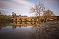
| Dee Bridge | Bridge | Chester 53°11′08″N 2°53′19″W / 53.1855°N 2.8887°W |
14th century | A sandstone bridge with seven arches crossing the River Dee. It was made wider in 1826. |
| Denhall hospital and limekiln | Earthworks and ruined walls | Neston 53°15′54″N 3°02′55″W / 53.2651°N 3.0486°W |
c. 1231–34 | The site of St Andrew's Hospital, a monastery hospital for travelers. Now has earthworks and ruined walls, plus a limekiln. |
| Dodleston Castle | Earthworks | Dodleston 53°08′28″N 2°57′23″W / 53.1411°N 2.9563°W |
Medieval | A flat-topped mound (motte) 3.3m high, with a clear walled area (bailey). |
| Dodleston Hall moated site | Moat | Dodleston 53°08′48″N 2°57′21″W / 53.1467°N 2.9559°W |
Medieval | A moated site where Dodleston Hall once stood. The moat is almost complete. |
| Drakelow Hall moated site | Moat and fishponds | Byley 53°13′38″N 2°26′39″W / 53.2273°N 2.4443°W |
Medieval | A rectangular moat with another moated site nearby and four fishponds. |
| Eccleston motte | Earthworks | Eccleston 53°09′30″N 2°52′48″W / 53.1584°N 2.8800°W |
Medieval (probable) | An oval mound, possibly a motte, partly surrounded by a ditch and banks. |
| Edleston moated site | Earthworks | Edleston 53°03′10″N 2°32′29″W / 53.0529°N 2.5415°W |
Medieval | A rectangular platform 50m by 30m surrounded by a dry moat. |
| Elton moated site | Earthworks | Elton 53°16′03″N 2°49′05″W / 53.2675°N 2.8181°W |
Medieval | An almost square moat with a path across one side and a channel to a fishpond. |
| Farndon Bridge | Bridge | Farndon 53°05′01″N 2°52′47″W / 53.0836°N 2.8798°W |
c. 1345 | A bridge crossing the River Dee and the England-Wales border. |
| Farnworth churchyard cross | Stone structure | Farnworth, Widnes 53°23′03″N 2°43′39″W / 53.3842°N 2.7275°W |
Medieval | The medieval base and plinth of a cross, with a 19th-century shaft. |
| Fir Tree Farm moated site | Earthworks | Chester 53°09′54″N 2°54′34″W / 53.1651°N 2.9094°W |
Medieval | A dry moat enclosing an area 15m wide with a bank and ditch. |
| Foulk Stapleford moated site | Earthworks | Foulk Stapleford 53°10′17″N 2°46′20″W / 53.1714°N 2.7723°W |
Medieval | A square moat with rounded corners, near the River Gowy. |
| Foxtwist moated site | Earthworks | Prestbury 53°18′55″N 2°09′25″W / 53.3152°N 2.1570°W |
Medieval | The remains of a deep inner moat that surrounded a raised platform, accessed by a causeway. |
| Gawsworth churchyard cross | Stone structure | Gawsworth 53°13′26″N 2°09′58″W / 53.2240°N 2.1660°W |
15th century | A square cross-base and an eight-sided shaft on a stepped plinth. It has carvings of beasts. |
| Gawsworth roadside cross | Stone structure | Gawsworth 53°13′52″N 2°10′08″W / 53.2310°N 2.1688°W |
Medieval | The base of a preaching cross made of stone blocks. |
| Glaziers Hollow | Glass works | Delamere Forest 53°14′47″N 2°42′03″W / 53.2464°N 2.7007°W |
15th–16th century | The likely site of a medieval glass furnace that burned wood, discovered in 1933. |
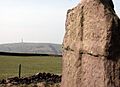
| Golden Stone | Boulder | Nether Alderley Over Alderley 53°17′39″N 2°12′25″W / 53.2942°N 2.2069°W |
Medieval | A large boulder that marked the boundary between two family estates. |
| Grafton | Earthworks | Grafton 53°03′23″N 2°49′27″W / 53.0563°N 2.8243°W |
Medieval | Signs of several ditched enclosures, possibly a deserted village, seen from above. |
| Great Merestone | Boulder | Finlow Hill 53°17′05″N 2°12′39″W / 53.2847°N 2.2107°W |
Medieval | A stone 1.3m wide and 0.4m high, marking a boundary. |
| Hall Bank moated site | Earthworks | Wybunbury 53°02′42″N 2°26′41″W / 53.0451°N 2.4448°W |
Medieval | Earthworks of a square moat and a path leading to the church. |
| Halton Castle | Ruined castle | Halton 53°19′59″N 2°41′45″W / 53.3331°N 2.6957°W |
c. 1070 and later | The ruins of a castle involved in the Civil War, later partly taken down. |
| Harthill Bank Castle | Earthworks | Oakmere 53°14′32″N 2°39′04″W / 53.2423°N 2.6511°W |
Medieval | An earthwork believed to be a motte and bailey castle. |
| Hatton Hall moated site | Earthwork | Hatton 53°08′38″N 2°47′27″W / 53.1440°N 2.7907°W |
Medieval | A square moat, mostly waterlogged, that once surrounded Hatton Hall. |
| Haycroft medieval village | Earthworks | Spurstow 53°06′39″N 2°39′58″W / 53.1108°N 2.6660°W |
Medieval | Photos from above show signs of a medieval village and its field system. |
| Headless Cross | Stone | Oakmere 53°12′24″N 2°37′31″W / 53.2066°N 2.6252°W |
Medieval | The stone base for a cross, but the shaft is missing. |
| Holford Hall moated site | Earthworks | Plumley 53°16′30″N 2°26′16″W / 53.2751°N 2.4377°W |
Medieval | An almost complete waterlogged moat, accessed by a stone bridge and path. A 17th-century farmhouse is on the platform. |
| Hough Hall moated site | Earthworks | Mere 53°20′47″N 2°25′10″W / 53.3464°N 2.4195°W |
Medieval | A platform surrounded by a dry moat, with two small fishponds and a dam. |
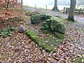
| Hulme Hall moated site | Moat | Allostock 53°14′52″N 2°24′50″W / 53.2478°N 2.4139°W |
Medieval | The moat and the ground under the bridge and hall are protected. |
| Huntington Hall moated site | Earthworks | Huntington 53°09′54″N 2°52′09″W / 53.1651°N 2.8692°W |
Medieval | The site of a moated manor house. |
| Huntington Hall moated site (south) | Earthworks | Huntington 53°09′07″N 2°51′16″W / 53.1520°N 2.8545°W |
Medieval | A square platform surrounded by a bank. |
| Iddinshall moat | Moat | Tarporley 53°09′34″N 2°41′52″W / 53.1594°N 2.6979°W |
Medieval | A large, now dry, moat surrounding an area where Iddinshall Hall once stood. |
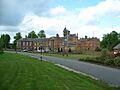
| Ince Manor | Buildings and earthworks | Ince 53°16′59″N 2°49′38″W / 53.2830°N 2.8271°W |
13th–14th century | Once a monastic grange (a farm owned by a monastery). It has earthworks from a possible moat and fishpond. |
| Jarman Farm moated site | Earthworks | Sutton Lane Ends 53°14′27″N 2°06′19″W / 53.2407°N 2.1053°W |
Medieval | A curved ditch, part of a former moat. It's the only circular medieval moated site in Cheshire. |
| Kinderton Hall moat and fishponds | Earthworks | Kinderton 53°11′58″N 2°26′21″W / 53.1995°N 2.4392°W |
Medieval | Earthworks from an old moat and fishponds. |
| Knutsford chapel | Stone slabs | Knutsford 53°18′19″N 2°21′10″W / 53.3053°N 2.3529°W |
Early 14th century | A chapel that stood here was taken down in 1741. |
| Lea Hall moat | Moat | Near Aldford 53°07′26″N 2°51′01″W / 53.1239°N 2.8503°W |
Medieval | A moated site where Lea Hall once stood. Part of the moat has been filled in. |
| Little Moreton Hall | Building, moat and garden | Odd Rode 53°07′38″N 2°15′08″W / 53.1271°N 2.2522°W |
15th century | A moated manor house site with remains of an Elizabethan garden. The timber framed hall is still there. |
| Longstone | Stone structure | Little Budworth 53°12′17″N 2°36′58″W / 53.2047°N 2.6160°W |
Medieval | Part of a medieval cross shaft on a modern base, located where a road leads to Vale Royal Abbey. |
| Longstone Lane wayside cross | Stone | Little Budworth 53°12′20″N 2°37′13″W / 53.2055°N 2.6203°W |
Medieval | A square stone with a hollow top on a 19th-century base. It's thought to have been a roadside cross and a plague stone. |
| Lovel's Hall moated site | Earthworks | Halebank 53°21′27″N 2°47′05″W / 53.3574°N 2.7846°W |
Medieval | A square moated platform with a dry ditch where Lovel's Hall once stood. |
| Lower Huxley Hall moated site | Moat and platform | Huxley 53°09′18″N 2°45′09″W / 53.1551°N 2.7524°W |
Medieval | A water-filled moat, partly lined with sandstone, with a platform now holding the 15th-century Lower Huxley Hall. |
| Lymm Hall moat and ice house | Earthworks | Lymm 53°22′45″N 2°28′33″W / 53.3793°N 2.4759°W |
Medieval | The site of a moated medieval manor house with its ice house on a nearby mound. |
| Maiden's Cross | Stone | Alvanley 53°15′24″N 2°43′46″W / 53.2568°N 2.7294°W |
Medieval | A stone with a chamber on its front. It might have been the base of a roadside cross or a plague cross. |
| Malpas Cross | Stone structure | Malpas 53°01′12″N 2°45′56″W / 53.0201°N 2.7655°W |
Medieval | The cross has a medieval eight-sided base with seven steps. The rest of the cross was added in 1873. |
| Marton churchyard cross | Standing stone | Marton 53°12′31″N 2°13′32″W / 53.2087°N 2.2255°W |
Medieval | The broken shaft of a cross on a stepped base in the churchyard. The rest of the shaft is inside the church. |
| Marton Grange moated site | Earthworks | Marton 53°12′13″N 2°33′58″W / 53.2036°N 2.5662°W |
Medieval | A moated site that held a monastic grange, accessed by a bridge, with fishponds. It also has a damaged stone base of a cross. |
| Merricks Hill chamber | Foundations | Delamere 53°13′06″N 2°40′08″W / 53.2183°N 2.6688°W |
c. 1354 | The foundations of a hunting lodge and administrative center for the Royal Forest of Delamere. |
| Middleton Grange moated site | Earthworks | Aston 53°17′18″N 2°40′03″W / 53.2883°N 2.6674°W |
Medieval | A moated site with eight fishponds and connecting channels. It was a monastic grange and later a hall and chapel site. |
| Mill Hill House Farm moat | Moat | Eccleston 53°09′24″N 2°53′51″W / 53.1567°N 2.8974°W |
Medieval | A square moat about 80m across, usually dry and covered in grass. |
| Minshull Vernon moated site | Earthworks | Minshull Vernon 53°08′20″N 2°27′58″W / 53.1389°N 2.4662°W |
Medieval | A complete double moat, with the outer moat dry and the inner one water-filled. A dry fishpond connects to the outer moat. |
| Mobberley churchyard cross | Stone structure | Mobberley 53°19′06″N 2°18′58″W / 53.3183°N 2.3161°W |
Medieval | A stone cross base and part of a cross shaft in the churchyard. |
| Monks Lane moated site | Moat and platform | Acton 53°04′27″N 2°33′18″W / 53.0743°N 2.5549°W |
Medieval | A square platform 10m wide surrounded by a water-filled moat. |
| Nether Alderley churchyard cross | Stone structure | Nether Alderley 53°16′54″N 2°14′20″W / 53.2818°N 2.2390°W |
Medieval | A cross base that is square at the bottom and eight-sided at the top, holding a rectangular shaft. |
| Nether Alderley village cross | Stone structure | Nether Alderley 53°17′21″N 2°14′10″W / 53.2891°N 2.2362°W |
Medieval | Built from buff and red sandstone, it has a large square base with three steps and a cube-shaped block. A broken shaft is set into it. |
| New Manor Farm moated site | Earthworks | Preston Brook 53°19′08″N 2°37′52″W / 53.3188°N 2.6311°W |
Medieval | A rectangular platform surrounded by a water-filled moat, where a modern farmhouse now stands. |
| Norbury Booths Hall moated site | Moat and earthworks | Knutsford 53°17′53″N 2°20′48″W / 53.2981°N 2.3467°W |
Medieval | The largest moat in Cheshire, partly water-filled. A stone chamber outside the moat, once a cess-pit, is connected by a stone-lined culvert. |
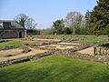
| Norton Priory | Ruined abbey | Norton, Runcorn 53°20′33″N 2°40′46″W / 53.3424°N 2.6795°W |
12th century and later | A former Augustinian abbey. After the Dissolution of the Monasteries, it became a Tudor, then Georgian house. The house was taken down in 1928, and the ruins are now a museum. |
| Old Hall Heys moated site | Earthworks | Hampton Heath 53°02′14″N 2°45′22″W / 53.037166°N 2.755984°W |
Medieval | A dry rectangular moat, 10–12m wide, enclosing an island 38m by 43m. |
| Overton | Earthworks | Overton 53°01′46″N 2°47′14″W / 53.0294°N 2.7872°W |
Medieval and post-medieval | Earthworks show platforms for buildings, old paths, and remains of ridge and furrow farming, indicating a deserted village. |
| Peel Hall moated site | Moated site | Kingsley53°16′29″N 2°41′27″W / 53.2747°N 2.6907°W | Medieval | A water-filled moat lined with a stone wall. The original house burned down in the 1660s, and a new house from 1840 now stands on the platform. |
| Peover Superior churchyard cross | Stone structure | Peover Superior 53°15′29″N 2°20′35″W / 53.2581°N 2.3431°W |
Medieval | The cross base is square, becoming eight-sided, and a new shaft was added in 1907. Part of the original shaft is used as a sundial base elsewhere in the churchyard. |
| Pott Shrigley churchyard cross | Stone | Pott Shrigley 53°18′35″N 2°05′06″W / 53.3098°N 2.0851°W |
Medieval | The base of the cross has two stepped stones, likely medieval. The shaft and cross were added later. |
| Prestbury Road cross | Standing stone | Near Macclesfield 53°16′22″N 2°09′19″W / 53.2728°N 2.1553°W |
11th century | A former parish boundary cross, consisting of a broken stone pillar. |
| Pulford Castle | Earthworks | Pulford 53°07′18″N 2°56′06″W / 53.1217°N 2.9349°W |
11th century | The remains include a mound with a surrounding earthwork. |
| Reaseheath moated site | Earthworks | Worleston 53°05′02″N 2°31′22″W / 53.0840°N 2.5228°W |
Medieval | An area surrounded by a rectangular moat, 53m by 43m, which is now dry. Part of the southern side has been destroyed. |
| Ridge Hall moated site | Moat and channels | Sutton, Macclesfield 53°14′06″N 2°05′53″W / 53.2350°N 2.0980°W |
Medieval | A dry rectangular moat with channels. It's the only Cheshire moat on a hillside and the highest in the county. |
| Rixton Hall moat | Moat | Near Hollins Green 53°24′01″N 2°28′38″W / 53.4004°N 2.4773°W |
Medieval | A water-filled moat. The current hall is located to the south. |
| Rushton Hall moated site | Earthworks | Eaton, Rushton 53°09′49″N 2°37′52″W / 53.1635°N 2.6312°W |
Medieval | A rectangular moated site with no sign of a building on the platform. Another moat nearby was likely a fishpond. |
| Saddlebole boundary marker | Stone | Nether Alderley Over Alderley 53°17′58″N 2°12′39″W / 53.2995°N 2.2109°W |
Medieval | A stone marking the boundary between Nether Alderley and Over Alderley. |
| Salterswall wayside cross | Stone | Winsford 53°11′55″N 2°33′33″W / 53.1986°N 2.5593°W |
Medieval | A square sandstone block with a hollow in its top. It's at a road junction and was probably the base for a cross. |
| Sandbach churchyard cross | Stone structure | Sandbach 53°08′36″N 2°21′40″W / 53.1434°N 2.3611°W |
Medieval | The base is a massive stone with two steps. On it is part of the shaft, which is rectangular at the bottom and becomes eight-sided. |
| Shocklach Castle | Earthworks | Shocklach 53°03′07″N 2°50′42″W / 53.0519°N 2.8449°W |
Medieval | A mound (motte) 4–5m high, and a D-shaped moated area. |
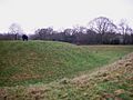
| Shotwick Castle | Earthworks | Saughall 53°13′37″N 2°58′33″W / 53.2270°N 2.9758°W |
Medieval | Earthworks include a mound, the remains of the motte, surrounded by a ditch with the bailey to the southeast. |
| Shotwick Hall moated site | Moat and island | Shotwick 53°14′28″N 2°59′48″W / 53.2412°N 2.9966°W |
Medieval | A moat, mostly filled with silt, surrounding an island about 25m by 32m, which now has a coppice (small trees). |
| Southley Manor moated site | Earthworks | Alpraham 53°07′43″N 2°37′40″W / 53.1286°N 2.6279°W |
Medieval | Two moated platforms with old field systems nearby. |
| Stanlow Abbey | Stone walls | Stanlow Point 53°17′24″N 2°51′33″W / 53.2900°N 2.8591°W |
1178 | A Cistercian monastery that moved in 1296. The site then became a monastic farm. Some walls and foundations are still there. |
| Stoak churchyard cross | Stone structure | Stoak 53°15′13″N 2°51′56″W / 53.2535°N 2.8655°W |
Medieval | A large square stone block with the lower part of a shaft that was turned into a sundial. |
| St Oswald's well | Well chamber | Winwick 53°26′32″N 2°35′33″W / 53.4421°N 2.5925°W |
Medieval | A holy well lined with stones and steps. It's overgrown and covered by a stone slab. |
| St Winefride's well | Well head and drain channel | Clutton 53°05′30″N 2°47′15″W / 53.0918°N 2.7874°W |
Medieval | A holy well with a stone wellhead and drainage channel. |
| Swineyard Hall moat | Moat | Near High Legh 53°21′01″N 2°29′07″W / 53.3503°N 2.4852°W |
Medieval | Three sides of the moat are kept as a stone-lined ornamental pond. A 16th-century hall stands on the platform. |
| Sutton End Farm cross | Stone | Sutton, Macclesfield 53°13′13″N 2°04′03″W / 53.2203°N 2.0676°W |
Medieval | A sandstone block that was used as a waymarker. |
| Tabley Old Hall | Derelict house on moated site | Tabley Inferior 53°17′33″N 2°25′18″W / 53.2926°N 2.4218°W |
c. 1380 and later | The remains of a house built in 1380, which later expanded. It partly collapsed in 1927, leaving a shell of the building. |
| Tarporley churchyard cross | Stone structure | Tarporley 53°09′28″N 2°40′09″W / 53.1579°N 2.6691°W |
Medieval | A square base of red sandstone and a shaft of yellow sandstone in the churchyard. |
| Tatton settlement, old hall and mill dam | Earthworks | Tatton Park 53°19′41″N 2°22′02″W / 53.3280°N 2.3673°W |
Late Neolithic, Saxon, and medieval | An old village site from different periods, now deserted with only earthworks remaining. Includes the ground under Tatton Old Hall. |
| Tilston churchyard cross | Stone structure | Tilston 53°02′59″N 2°48′40″W / 53.0497°N 2.8110°W |
Medieval | A cross with two steps and an eight-sided base supporting an eight-sided shaft. |
| Toothill enclosure | Earthworks | Macclesfield Forest 53°14′43″N 2°02′38″W / 53.2454°N 2.0440°W |
Medieval | A four-sided enclosed area whose purpose is not fully known. |
| Upton Grange moat | Moat | Upton 53°12′59″N 2°51′50″W / 53.2163°N 2.8640°W |
Medieval | A dry moat to the east of Upton Grange. |
| Vale Royal Abbey | Buildings, foundations | Vale Royal 53°13′29″N 2°32′32″W / 53.2247°N 2.5423°W |
Medieval | Once the largest Cistercian church in England. It was taken down after the Reformation and replaced by a large house. |
| Venables' tomb | Canopied tomb | Newbold Astbury 53°09′02″N 2°13′53″W / 53.1505°N 2.2315°W |
Late 13th century | A tomb with a canopy in the churchyard. |
| Warmingham churchyard cross | Stone structure | Warmingham 53°08′45″N 2°26′11″W / 53.1459°N 2.4364°W |
c. 1298 | A cross base with three steps and a socket stone, to which a later shaft was added. |
| Wervin chapel | Ruined building | Wervin 53°14′25″N 2°52′16″W / 53.2403°N 2.8711°W |
13th century or earlier | The ruins of an old chapel. |
| Wood Farm moated site | Earthworks | Woolstanwood 53°05′58″N 2°29′41″W / 53.0995°N 2.4947°W |
Medieval | A trapezoidal-shaped moat that surrounded a platform 90m square. |
| Woodhey wayside cross | Stone structure | Faddiley 53°04′10″N 2°37′56″W / 53.0694°N 2.6323°W |
Medieval | The remains of a medieval roadside cross at a crossroads. It has a square part of a shaft on a stone base, with later stones added. |
| Wybunbury moated site | Moat | Wybunbury 53°02′33″N 2°26′45″W / 53.0426°N 2.4457°W |
Medieval | A moat surrounding a platform 40m square, with channels, a path, and a nearby fishpond. |
Images for kids
-
Former cross in Acton churchyard converted into a sundial
-
Agricola Tower, Chester Castle
-
Barrow churchyard cross
-
Beeston Castle gateway to main keep
-
Bewsey Old Hall. The site on which it stands is scheduled
-
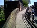
Part of Chester city walls
-
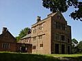
Chorley Old Hall medieval range
-
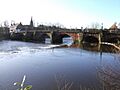
Dee Bridge
-
Farndon Bridge
-
Ruins of Halton Castle
-
Hulme Hall Moat
-
Ince Manor Hall April 2008
-
Longstone
-
Longstone Lane wayside cross
-
Norton Priory ruins
-
Earthworks of Shotwick Castle
-
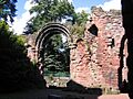
Part of St John's church ruins
-
Sutton End Farm cross
-
Vale Royal Abbey in 2008
-
The Golden Stone, Alderley Edge


