
List of scheduled monuments in Cheshire since 1539 facts for kids
There are over two hundred special historical sites in Cheshire, a county in North West England. These sites range from the Stone Age up to the middle of the 20th century. This list focuses on the special historical sites in Cheshire from 1540 to today. This period is known as post-medieval and modern history.
A special historical site is an important old place or building that is protected by law. It's put on a special list by the government minister in charge of culture. English Heritage, a group that protects old places, helps find these sites. A law from 1979 helps protect them. The word "monument" can mean all sorts of old places. They are not always visible above ground. These sites must have been built on purpose by people. They include everything from ancient standing stones and burial sites to Roman ruins and medieval castles. Later sites include old factories and buildings from the World Wars or the Cold War.
This list includes buildings from the time after the Middle Ages, through the Industrial Revolution, and up to sites used for wars in the 20th century. The older sites are often like those from the Middle Ages. These include moats (ditches filled with water) or places that had moats. They also include churchyard crosses, buildings for doves (a dovecote), and special traps for ducks (a duck decoy).
Sites from the Industrial Revolution include old mine remains, canal locks and a bridge, a salt factory, a boat lift, and a transporter bridge inside a factory. The sites from the 20th century are a former Royal Air Force airfield and three places where anti-aircraft guns were set up.
Contents
- Amazing Historical Sites in Cheshire
- Anderton Boat Lift
- Old Beacons and Dovecotes
- Bridges and Canals
- Industrial History
- Other Interesting Sites
- Burton Manor Icehouse
- Daresbury (Mersey Flat)
- Gawsworth Old Hall Gardens
- Great Moreton Hall Icehouse Tower
- Hale Duck Decoy
- Huntington Hall
- Kinderton Hall Gardens
- Lymm Hall Cockpits
- Marton Grange
- Newbold Astbury Churchyard Cross
- Over Churchyard Cross
- Overton
- Poynton Hall Icehouse
- Shocklach Churchyard Cross
- Tilstone Hall Gateway
- World War II Sites
- Images for kids
- See also
Amazing Historical Sites in Cheshire
Anderton Boat Lift
The Anderton Boat Lift is a very clever machine built in 1875. It's like a giant elevator for boats! It lifts and lowers boats between the Weaver Navigation and the Trent and Mersey Canal. It was powered by electricity and is a unique piece of engineering history.
Old Beacons and Dovecotes
Armada Beacon
At Alderley Edge, you can find the foundations of the Armada Beacon. This was a platform for one of many beacons built in the 16th century. These beacons were lit to warn people if an invasion was coming, like from the Spanish Armada.
Aston Dovecote
The Aston dovecote was built in 1691. It's a building for keeping doves or pigeons. This one is special because it's one of the few "double" dovecotes in England. It's now without a roof or a wall inside.
Jodrell Bank Dovecote and Pigsty
Near Twemlow, there's a three-storey brick building from the late 17th century. The bottom floor was a pigsty for pigs, and the top two floors were a dovecote for pigeons.
Bridges and Canals
Bank Quay Transporter Bridge
The Bank Quay Transporter Bridge in Warrington was built between 1913 and 1915. It's a special type of bridge that carries a moving platform. This one is no longer used and is inside the old Joseph Crosfield and Sons factory.
Beeston Lock
Beeston lock is a unique canal lock on the Shropshire Union Canal. It was built in 1827–28 and was designed by the famous engineer Thomas Telford. It's made of cast iron, which was very modern for its time.
Bunbury Locks
Also on the Shropshire Union Canal are the Bunbury locks, built between 1775 and 1779. These locks help boats go up or down hills. They also have an old bridge and stables nearby.
Crossley Bridge
Crossley (or Colleymill) Bridge is a stone bridge from the 17th or 18th century. It has two arches and carries the A54 road over the River Dane near Congleton.
Wrenbury Lifting Bridge
Near Wrenbury, there's a wooden lifting bridge from around 1790. It carries a road over the Llangollen Canal and was also designed by Thomas Telford.
Industrial History
Danebower Colliery Chimney
In Wildboarclough, you can see a stone chimney from the early 19th century. This chimney was used for ventilation at a coal mine called Danebower colliery.
Former Soda Ash and Calcium Nitrate Works
Near Plumley, you can find the remains of old factories from the early 20th century. One factory made soda ash using a special process, and the other made calcium nitrate.
Lion Salt Works
The Lion Salt Works in Marston started in 1842. It was a factory that made salt using an open pan method until 1986. Now, it's a museum where you can learn how salt was made.
Murgatroyd Brine Shaft
In Middlewich, there's an underground mine shaft called Murgatroyd brine shaft, dug in 1889. This shaft was used to get salty water (brine) from underground. It still has three old pumps from the 20th century.
West Mine Plant
The West Mine Plant near Nether Alderley was a mining complex in the mid-19th century. Here, they dug for and processed copper, lead, and cobalt ores.
Other Interesting Sites
Burton Manor Icehouse
An icehouse is a building used to store ice, usually for keeping food cold. The Burton Manor icehouse, from the early 19th century, is cut into rock. It's unusual because it had gas lighting and an area for preparing food.
Daresbury (Mersey Flat)
Near Sutton, you can find the remains of a "Mersey flat" boat called Daresbury. This type of boat was used on the River Mersey. This particular boat is the only known one from before 1840.
Gawsworth Old Hall Gardens
At Gawsworth Old Hall, you can see the remains of an Elizabethan garden. It has five ornamental pools that were likely built for outdoor entertainment.
Great Moreton Hall Icehouse Tower
This tower, built in 1841, is part of an icehouse. It's a castellated (like a castle) tower over a tunnel that leads to the icehouse itself.
Hale Duck Decoy
The Hale Duck Decoy is a special enclosure from the 17th century. It has a central pond and five curving arms, designed to trap ducks. It has been restored and is now a nature reserve.
Huntington Hall
Huntington Hall has a Sandstone bridge and a causeway (a raised road over wet ground) from the post-medieval period. These led to a platform where a moated manor house or farm used to stand.
Kinderton Hall Gardens
At Kinderton Hall, you can see earthworks (changes in the ground) from a former formal garden. These are to the west of a medieval moat and include a "prospect mound," which was a raised area for good views.
Lymm Hall Cockpits
At Lymm Hall, there are two well-preserved but overgrown cockpits from the 17th century. These were places where cockfights (fights between roosters) used to happen.
Marton Grange
Marton Grange was a manor house that was knocked down in 1848. The site also includes a sandstone socket stone, which was once the base of a cross.
Newbold Astbury Churchyard Cross
This stone cross in Newbold Astbury is from the 16th century. It has an octagonal (eight-sided) base with steps, and a later top part has been added. It stands in St Mary's churchyard.
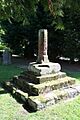
Over Churchyard Cross
The Over churchyard cross, from around 1543, is made of yellow sandstone. It has a stepped octagonal base and the lower part of a shaft. This shaft was cut short to make a sundial. It stands in St Chad's churchyard.
Overton
At Overton, you can see earthworks like platforms for buildings, hollow ways (old sunken roads), and ridge and furrow marks from farming. These suggest that there was once a village here that is now deserted.
Poynton Hall Icehouse
Most of the Poynton Hall icehouse, built around 1758, is below ground. It's made from local sandstone and was used to store ice.
Shocklach Churchyard Cross
This red sandstone cross in Shocklach has three steps and a base with a partly restored shaft. It stands in St Edith's churchyard.
Tilstone Hall Gateway
The ruin of a gateway to Tilstone Hall can be found near Tarporley. It's from the late 16th or early 17th century. The house itself was knocked down around 1740.
World War II Sites
Norley Anti-Aircraft Battery
Near Norley, you can find the foundations and buildings of an anti-aircraft battery from around 1950. This site had housing for four large anti-aircraft guns, a strong concrete building for a generator, a gunshed, and a command post.
Pickett-Hamilton Fort
At Burtonwood, there are underground remains of a former USAAF fort from 1940–41. You can still see rusted items, including hydraulic jacks, under a round concrete slab.
Puddington Anti-Aircraft Gunsite
Near Puddington, you can see the remains of four gun pits and a command post from around 1941. These were built during the Second World War to hold heavy anti-aircraft guns.
RAF Cranage
RAF Cranage was an airfield used by the RAF during the Second World War. It was built in 1939. The site includes the Defence Headquarters, a gun pit, a sleeping shelter for aircrew, and four pillboxes (small, strong concrete shelters for soldiers).
Sutton Anti-Aircraft Gunsite
This site near Sutton Weaver was a heavy anti-aircraft gunsite built in 1940 during the Second World War. The remains include five gun emplacements (places where guns were set up), the command post, two garages, and a generator building.
Images for kids
-
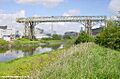
Bank Quay Transporter Bridge
-
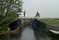
Beeston lock
-
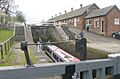
Bunbury locks
-
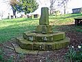
Over churchyard cross
-
Shocklach churchyard cross
-
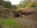
An entry to one of the mines in the West Mine Plant on Alderley Edge


See also
