Little Applegate River facts for kids
Quick facts for kids Little Applegate River |
|
|---|---|

The Little Applegate River
|
|
|
Location of the mouth of the Little Applegate River in Oregon
|
|
| Country | United States |
| State | Oregon |
| County | Jackson |
| Physical characteristics | |
| Main source | Near Siskiyou Peak Siskiyou Mountains, Jackson County, Oregon 5,735 ft (1,748 m) 42°03′06″N 122°48′15″W / 42.05167°N 122.80417°W |
| River mouth | Applegate River about 3 miles (4.8 km) northwest of Buncom, Jackson County, Oregon 1,440 ft (440 m) 42°11′55″N 123°02′43″W / 42.19861°N 123.04528°W |
| Length | 21 mi (34 km) |
| Basin features | |
| Basin size | 113 sq mi (290 km2) |
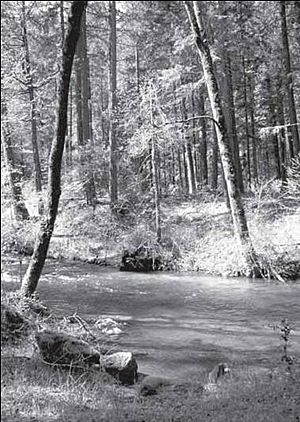
The Little Applegate River is a river in Oregon, United States. It is about 21 miles (34 km) long. This river is a smaller stream that flows into the Applegate River. It is part of the larger Rogue River system.
The Little Applegate River helps drain about 113 square miles (290 km²) of land in Jackson County. It starts in the Siskiyou Mountains. The river then flows mostly northwest. It joins the Applegate River near the small towns of Buncom and Ruch.
People have lived near the Little Applegate River for a very long time. Native American tribes like the Latgawa, Shasta, and Dakubetede lived here about 11,000 years ago. Later, in the 1800s, settlers came looking for gold. Two towns, Sterlingville and Buncom, grew quickly because of gold mining. Over time, as the gold ran out, these towns became much smaller. Today, only a few buildings remain in Buncom, and Sterlingville is gone.
Even with some water quality issues, the Little Applegate River is home to many animals. It has coho and Chinook salmon. Many other animals with backbones (vertebrates) also live here. Most of the land around the river is covered by forests.
Contents
The River's Journey
The Little Applegate River begins from several springs high up in the Siskiyou Mountains. These springs are found near Siskiyou Peak. As the river flows north, it gains water from smaller streams. McDonald Creek joins it from the right, and Glade Creek joins from the left.
Long ago, some of the river's water was moved into a channel called Sterling Ditch. This ditch was built in 1877. It was about 23 miles (37 km) long. It helped bring water to the town of Sterlingville for a type of mining called hydraulic mining. This mining used powerful jets of water to wash away dirt and find gold.
After the water diversion, the river turns and flows northwest. About five miles (8 km) downstream, a big stream called Yale Creek joins it from the left. Yale Creek drains a large area, making it the biggest stream flowing into the Little Applegate. Further along, Sterling Creek also adds its water to the river. The small town of Buncom is located where Sterling Creek meets the Little Applegate.
Finally, the Little Applegate River flows into the Applegate River. This meeting point is about 2 miles (3.2 km) northwest of Buncom. For fish swimming upstream, the Little Applegate is the last major stream they can enter before reaching the Applegate Dam. The dam blocks their path further up the Applegate River. The amount of water flowing in the Little Applegate changes a lot. It averages about 226 cubic feet per second (6.4 m³/s). But it can be much lower or higher depending on the season and how much rain falls.
Understanding the Watershed
A watershed is an area of land where all the water drains into a single river or stream. The Little Applegate River watershed covers about 113 square miles (290 km²) in southern Oregon. This area makes up about 15 percent of the Applegate River's watershed. It is also about 2 percent of the much larger Rogue River basin.
Most of the land in the watershed is managed by government groups. The Bureau of Land Management controls 40 percent, and the United States Forest Service owns 32 percent. Private owners have 27 percent of the land. Less than one percent is owned by the state of Oregon. About 96 percent of the land is covered by forests or woodlots (small forests). The remaining 4 percent is farmland or rural areas.
The Little Applegate watershed has a Mediterranean climate. This means it has warm, dry summers and mild, wet winters. On average, the area gets about 38 inches (970 mm) of rain each year. However, it can get as much as 55 inches (1,400 mm) or as little as 20 inches (510 mm). Most of the rain falls as liquid water, but snow can fall in the higher mountains.
The land in the watershed is made of old rocks that have changed over time. These rocks are similar to those found in the Siskiyou Mountains. The elevation in the watershed varies greatly. It is 1,440 feet (439 m) at the river's mouth. It goes up to 7,418 feet (2,261 m) at Dutchman Peak. Streams at higher elevations flow more slowly because glaciers once shaped the land there. Then, they drop quickly until they reach the flatter Little Applegate Valley. This valley has a lot of alluvial deposits, which are sediments carried and deposited by water.
Plants and Animals: Life in the Watershed
The Little Applegate watershed is mostly covered by temperate coniferous forest. These forests make up about 64 percent of the area. Common trees include Douglas-fir, ponderosa pine, madrone, and incense-cedar. In drier, brushy areas called chaparral, you can find plants like buckbrush and manzanita.
Several rare plants also grow here. These include Gentner's fritillary and Siskiyou lewisia. However, some harmful plants, called noxious weeds, have also been found. These include different types of thistles and Scotch broom.
Before the 1940s, wildfires were common in the watershed. But then, people started trying to stop all fires. This changed the forest. Trees that need fire to grow, like ponderosa pine, became less common. Other trees, like Douglas-fir, spread more. The forests became denser. This makes them more likely to get sick from insects or diseases.
Many animals live in the Little Applegate watershed. Scientists know of 138 different kinds of vertebrates (animals with backbones). They suspect another 134 kinds might live there too. A large part of the watershed is a special protected area for the northern spotted owl. This owl is an endangered animal, meaning it is at high risk of disappearing forever.
Other rare animals in the watershed include the Siskiyou Mountains salamander, which is also endangered. The western pond turtle is considered vulnerable. Animals like bighorn sheep, gray wolves, grizzly bears, and pronghorns used to live here. But they are no longer found in this area.
The most common fish in the river are Chinook salmon, coho salmon (which are threatened), and rainbow trout. However, the number of fish is going down. This is because the water quality is not always good. Also, things like dams and culverts (pipes under roads) can block fish from moving freely.
A Look Back: History of the River Area
People have lived in the Little Applegate River watershed for about 11,000 years. Early tools found here, called Clovis points, show this long history. The first people were likely the Latgawa, Shasta, and Dakubetede Native American tribes. They were descendants of people who crossed the Bering land bridge from Asia. They fished for salmon and hunted deer and elk. They also used to set fires to clear land. These fires helped different plants and animals grow, making the area more diverse.
The first European Americans came to the area in 1827. They were fur trappers led by Peter Skene Ogden. In 1851, Chinese miners started the community of Buncom. They found gold and other valuable metals nearby. In 1854, James Sterling and Aaron Davis found gold in Sterling Creek. Soon, hundreds of miners arrived. The town of Sterlingville quickly grew to over 1,500 people.
Mining continued through the 1850s and 1860s. Miners dug up much of the riverbeds in Sterling Creek and the lower Little Applegate River. The Sterling Ditch, which brought water for mining, was built in the 1870s. Sterlingville became the biggest hydraulic mine in Oregon. This type of mining caused a lot of dirt and sediment to wash into the river.
As the gold ran out, the towns became smaller. Sterlingville's post office opened in 1879 but closed four years later. Buncom's post office opened in 1896 but closed in 1918. Most mining stopped by 1910. Some hydraulic mines reopened during the Great Depression from 1933 to 1957. Today, only three buildings remain in Buncom, and Sterlingville is gone.
In the late 1990s, farmers agreed to move their water rights to the Applegate River. This allowed two large dams on the Little Applegate River to be removed. The first dam was removed in 2006, and the second in 2012. Removing these dams helped more water flow back into the Little Applegate River. It also opened up about 35 miles (56 km) of streams for fish to swim and migrate freely.
River Health: Pollution and Solutions
The water quality in the Little Applegate River watershed is often not very good. This is due to high water temperatures, too much sedimentation (dirt and sand settling), and low oxygen saturation levels. Most of these problems are caused by human activities.
For example, forests and riparian zones (areas along the riverbanks) have been cleared for farming. Many roads in the area can also cause landslides, sending dirt into the river. The old hydraulic mining near Sterlingville also damaged the land. It left bare slopes that sent rocks and gravel downstream.
In the late 1800s, Cattle and sheep were brought to the area. They sometimes overgrazed the land, meaning they ate too much grass. This reduced native plants and allowed harmful weeds to spread. Overgrazing also makes the soil more likely to wash away. Also, a lot of water is taken from the river for other uses. Sometimes, this leaves the river's mouth almost dry.
McDonald Ditch, an irrigation ditch near McDonald Creek, is a big source of sedimentation. This ditch was built in 1920 to bring water to people. But it has broken many times, sending tons of dirt and mud into the river. In 2010, the Talent Irrigation District decided to buy a system to monitor the ditch. They also asked for money to replace the ditch with pipes. This would help keep the river cleaner.
 | John T. Biggers |
 | Thomas Blackshear |
 | Mark Bradford |
 | Beverly Buchanan |


