Little River (Red River tributary) facts for kids
Quick facts for kids Little River |
|
|---|---|

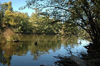
The lower course of the Little River features swamps, Bald Cypress forests, and American alligators at the northwestern limit of their range.
|
|

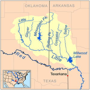
Map of the Little River watershed
|
|
| Country | United States |
| States | Oklahoma, Arkansas |
| Physical characteristics | |
| Main source | 70 m (230 ft) |
| River mouth | Red River |
| Length | 350 km (220 mi) |
| Basin features | |
| River system | Red River (Mississippi watershed) |
| Basin size | 10,889 km2 (4,204 sq mi) |
The Little River is a river in the United States. It flows through southeastern Oklahoma and southwestern Arkansas. The river is about 217 miles (349 km) long. It is a tributary of the Red River. This means the Little River flows into the Red River.
The Red River then flows into the Mississippi River. So, the Little River is part of the huge watershed of the Mississippi River. A watershed is an area of land where all the water drains into one main river. The Little River's watershed covers about 4,204 square miles (10,890 km2). This includes 2,204 square miles (5,710 km2) in Oklahoma and 2,036 square miles (5,270 km2) in Arkansas.
Many large lakes have been created on the Little River and its smaller streams. These lakes are made by dams. The Little River and its upper parts are popular for fun activities like canoeing and kayaking.
Contents
Where the Little River Flows
The Little River starts high up in the Ouachita Mountains. Its highest points are over 2,000 feet (610 m) high. These are in southwestern Le Flore County, Oklahoma. The river first flows west into Pushmataha County, Oklahoma. Then it turns south into McCurtain County, Oklahoma.
In McCurtain County, it changes direction again. It flows southeast past Wright City, Oklahoma. It also flows through the Little River National Wildlife Refuge. Part of its path is in the Ouachita National Forest. From there, it enters Arkansas.
In Arkansas, the river flows through or along the edges of several counties. These include Sevier, Little River, and Hempstead counties. It also passes the Pond Creek National Wildlife Refuge. The Little River finally joins the Red River about 1 mile (1.6 km) west of Fulton. This is where Little River and Hempstead counties meet.
Smaller Rivers Joining the Little River
Many smaller rivers flow into the Little River. In Oklahoma, the main ones are the Glover River and the Mountain Fork. Both of these join the Little River in McCurtain County.
In Arkansas, other rivers add to its flow. The Rolling Fork and the Cossatot River join from the north in Sevier County. The Saline River also flows into Millwood Lake. This happens where Sevier and Howard counties meet.
Lakes and Dams
The U.S. Army Corps of Engineers has built several dams on the Little River. These dams create large lakes.
- Pine Creek Lake in Oklahoma covers 3,750 acres (1,520 ha).
- Millwood Lake in Arkansas covers 29,200 acres (11,800 ha).
Dams on the smaller rivers that flow into the Little River also create lakes:
- Broken Bow Lake in Oklahoma covers 14,200 acres (5,700 ha).
- In Arkansas, there are DeQueen Lake (1,680 acres (680 ha)), Gillham Lake (1,370 acres (550 ha)), and Dierks Lake (1,360 acres (550 ha)).
Even though the Little River is not super long, it carries a lot of water. It is the sixth largest river in Oklahoma by how much water flows through it. Near the Arkansas border, it averages about 3,275 cubic feet of water per second. The river starts in the Ouachita Mountains, which get a lot of rain. They can receive up to 60 inches (1,500 mm) of rain each year. There are no big cities directly on the Little River. However, Idabel, Oklahoma and DeQueen, Arkansas are close by.
Fun and Nature Along the River
The Little River and its main smaller rivers are great places for canoeing and kayaking. The upper part of the Little River, from Honobia, Oklahoma to Pine Creek Lake, is about 46 river miles long. This section has a gentle slope and some easy rapids. These are called Class I and II rapids.
After Pine Creek Lake, the river leaves the mountains. It then flows through a flat, swampy area. From July to September, the upper river might not have enough water for boating unless it has rained recently. The water in the Little River is usually very clean. There are not many homes or businesses built along its banks.
Wildlife and Fishing
The Honobia Creek Wildlife Management Area (WMA) covers 80,316 acres (32,503 ha). Much of the upper Little River flows through this area. The WMA is a partnership between the Oklahoma government and three timber companies. Most of the land is used for growing Loblolly Pine trees. But some areas have natural hardwood forests. About 21 miles of the river flow through the WMA.
You can find many types of fish here, including:
You need to pay a fee to enter the WMA.
The Little River National Wildlife Refuge in Oklahoma and the Pond Creek National Wildlife Refuge in Arkansas protect parts of the lower Little River. These refuges provide homes for many different animals and plants. The Little River NWR is 13,660 acres (5,530 ha). It has the largest Bald Cypress tree in Oklahoma. It also has the largest examples of ten other tree species in Oklahoma.
Pond Creek NWR covers 30,500 acres (12,300 ha) on the north side of the Little River. You can find American alligators living and raising their young in Millwood Lake and Pond Creek NWR. Alligators are sometimes seen in the Little River National Wildlife Refuge too. This lower part of the river has swamps, slow-moving water, and forests that flood during certain seasons.

