Maesglase facts for kids
Quick facts for kids Maesglase |
|
|---|---|
 |
|
| Highest point | |
| Elevation | 678.5 m (2,226 ft) |
| Prominence | 318 m (1,043 ft) |
| Listing | Marilyn, Hewitt, Nuttall |
| Naming | |
| English translation | blue/green field |
| Language of name | Welsh |
| Geography | |
| Location | Snowdonia, Wales |
| Parent range | Cadair Idris |
| OS grid | SH817150 |
| Topo map | OS Explorer OL23 |
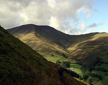
Maesglase is a mountain located in Snowdonia, North Wales. It stands about four miles southwest of Aran Fawddwy. Maesglase is special because it is the highest peak in the Dyfi Hills.
Contents
Getting to Maesglase
You can reach Maesglase by taking a walk through the forest from Dinas Mawddwy. It's an easy but steep climb. Another way to get there is directly from the bwlch (a mountain pass) on the A470.
When you climb Maesglase, you can also explore other nearby peaks. These include Maen-Du, Craig Rhiw-erch, Waun-oer, Craig Portas, and Cribin Fawr. These peaks are connected by a series of ridges, which are like narrow mountain paths.
How Tall is Maesglase?
The exact height of Maesglase has been a bit confusing! For a long time, people thought the top of Maen Du was the highest point. It stands at about 674 meters (2,211 feet).
However, newer surveys suggest that Craig Rhiw-erch is actually taller. It's about 676 meters (2,218 feet) high. The most recent survey found the true summit to be 678.5 meters (2,226 feet) tall.
Mountain Shapes and Waterfalls
The mountains around Maesglase have classic U-shaped valleys. These valleys were carved out by glaciers a long time ago. You can also see perfect examples of hanging valleys here. These are valleys that are higher than the main valley they join.
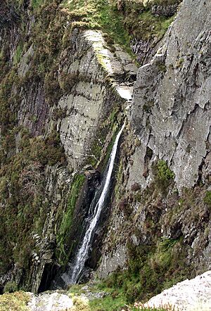
One amazing feature is the Maesglase waterfall. It falls a total of 160 meters (525 feet)! This waterfall comes from a hanging valley on the side of Maesglase.
Life on the Mountain Slopes
The eastern side of Maesglase is used for raising sheep. The western slopes are covered with thick forests.
Above the grassy areas, you'll find some bracken plants. Much of the higher ground is covered in plants like Calluna (heather) and Erica (heath). You can also find large areas of bogs, which are wet, spongy lands with plants like Juncus (rushes), Carex (sedges), and Sphagnum moss.
The tops of Cribin Fawr are flat areas with peat-hags. These are uneven areas of peat, which is decayed plant matter. On the eastern slopes, you'll see lots of Bilberry plants. Cowberry plants are also common on the highest parts of the mountain.
Old Boundary Marker
About half a mile west of Cribin Fawr's peak, there's an old stone boundary marker. It's from 1861 and has "CCC" carved into it. It also has a benchmark, which is a special mark used by surveyors to show a precise height.
Nearby Ridges
To the south of Maesglase, there are two parallel ridges. These ridges lead to other peaks called Mynydd Dolgoed and Mynydd Gartheiniog.
 | Georgia Louise Harris Brown |
 | Julian Abele |
 | Norma Merrick Sklarek |
 | William Sidney Pittman |


