
Mahoning River facts for kids
Quick facts for kids Mahoning River |
|
|---|---|

The Mahoning River in Youngstown, Ohio
|
|

Map of the Beaver River watershed including the Mahoning River
|
|
| Country | United States |
| States | Ohio, Pennsylvania |
| Physical characteristics | |
| Main source | One half mile southwest of Winona, Ohio 395 m (1,296 ft) above sea level 40°49′18″N 80°54′12″W / 40.82167°N 80.90333°W |
| River mouth | Beaver River near Mahoningtown, New Castle, Pennsylvania 232 m (761 ft) above sea level 40°57′29″N 80°22′43″W / 40.95806°N 80.37861°W |
| Length | 182 km (113 mi) |
| Basin features | |
| Basin size | 2,932 km2 (1,132 sq mi) |
The Mahoning River is a river that flows through parts of Ohio and Pennsylvania in the United States. It starts in northeastern Ohio and then crosses into western Pennsylvania. The Mahoning River eventually joins with the Shenango River to form the Beaver River. It's an important part of the larger Ohio River watershed. The river drops from about 1,296 feet (395 meters) where it begins near Winona, Ohio to 761 feet (232 meters) near Mahoningtown, Pennsylvania.
Contents
What's in a Name?
The name "Mahoning" comes from the Lenape people. They are a Native American group. In their language, the word mahonink means "at the licks" or "there is a lick." This refers to salt licks that were found in the area. Animals would visit these spots to lick salt from the ground.
River Facts and Features
The Mahoning River begins near Winona, Ohio in Columbiana County, Ohio. It flows for about 113 miles (182 km). The area of land that drains into the river, called its watershed, is about 1,132 square miles (2,932 km²).
The river flows through five counties in Ohio: Columbiana, Stark, Portage, Trumbull, and Mahoning. It also goes through Lawrence County, Pennsylvania in Pennsylvania. Some parts of Ashtabula and Geauga counties in Ohio also drain into the Mahoning River.
River Branches and Dams
The Mahoning River has three main smaller rivers, called tributaries, that flow into it. These are Mosquito Creek, West Branch, and Eagle Creek, all located in Ohio. There are also 15 dams built along the river's path. Most of the river, about 97.1 miles (156.3 km), is in Ohio, with the rest in Pennsylvania.
Wildlife in the River
The Mahoning River is home to many different kinds of animals. More than 72 types of fish live in its waters. You can also find 15 different kinds of freshwater mussels there.
Different Parts of the River
The Mahoning River can be thought of in two main sections. The "upper part" flows north and east from Winona to Leavittsburg, Ohio. This area is mostly countryside, with forests, farms, and game lands.
The "lower part" flows mainly southeast from Leavittsburg to where it meets the Beaver River. This section has more people and industries. Cities like Warren, Niles, and Youngstown are along this part of the river. This area has a long history of steel making and other industries.
Environmental Concerns
Because of all the factories and industries along the lower part of the Mahoning River, there has been a lot of pollution. Much of this pollution has been carried away by the river's flow. However, experts believe that about 750,000 cubic yards (573,416 m³) of dirt and sand at the bottom of the river and along its banks are heavily polluted. This is over a 30-mile (48.2 km) stretch from Leavittsburg to the Pennsylvania border.
About 45% of this polluted material is near the Girard Dam, close to Girard, Ohio. This dam has acted like a trap, collecting much of the contaminated dirt. Harmful chemicals like petroleum hydrocarbons, benzo(a)pyrene, and mercury have been found in the river. These are at levels much higher than what is considered safe.
Since 1988, the Ohio Department of Health has warned people not to swim or wade in the river between Leavittsburg and the Pennsylvania border. They also advise against eating fish caught in this area. The Corps of Engineers estimates that cleaning up this pollution could take up to 15 years and cost more than $100 million.
Cities and Towns Along the River
Many cities and towns are located along the Mahoning River:
Flooding and River Changes
The Mahoning River can flood often when there is a lot of rain. One big flood happened from March 23 to March 26, 1913. During this time, people in Youngstown didn't have water. Many communities like Leavittsburg and Lowellville were damaged. Factories in the area lost millions of dollars. Floodwaters almost reached the roofs of the Republic Steel plant. Some bridges even fell down. After this, projects were started to control the water, like building the Lake Milton dam between 1913 and 1917.
Another major flood happened in July 2003. Three days of heavy rain caused so much water that the river actually changed its path in Leavittsburg, Ohio. This flood destroyed almost 100 homes. In the upper half of the river, the land is quite flat. This means the river can easily change its course during heavy floods. Near Youngstown, Ohio, the river valley is deeper, so the river is more contained. However, it can still change its path in smaller areas.
Images for kids
-
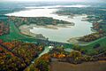
Berlin Lake and Dam on the Mahoning River. This view looks upriver.
-

The Mahoning River below Berlin Lake and Dam. Lake Milton can be seen far away.


