Mason County, Michigan facts for kids
Quick facts for kids
Mason County
|
|
|---|---|

|
|

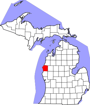
Location within the U.S. state of Michigan
|
|
 Michigan's location within the U.S. |
|
| Country | |
| State | |
| Founded | 1840 (founded as Notipekago) 1855 (organized) |
| Named for | Stevens T. Mason |
| Seat | Ludington |
| Largest city | Ludington |
| Area | |
| • Total | 1,242 sq mi (3,220 km2) |
| • Land | 495 sq mi (1,280 km2) |
| • Water | 747 sq mi (1,930 km2) 60%% |
| Population
(2020)
|
|
| • Total | 29,052 |
| • Density | 58/sq mi (22/km2) |
| Time zone | UTC−5 (Eastern) |
| • Summer (DST) | UTC−4 (EDT) |
| Congressional district | 2nd |
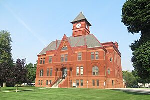
Mason County is a place in Michigan, a state in the United States. In 2020, about 29,052 people lived there. The main town, or county seat, is Ludington.
Mason County is part of what's called the Ludington, MI Micropolitan Statistical Area. This just means it's an area with a city (Ludington) and nearby towns that are closely connected.
Contents
History of Mason County
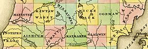
Mason County is named after Stevens T. Mason. He was the Governor of Michigan from 1835 to 1840. The Michigan Legislature created the county in 1840. Its first name was Notipekago County.
Then, in 1843, its name was changed to Mason County. Before 1855, another county, Ottawa County, helped manage Mason County. This was until Mason County set up its own local government.
Geography and Nature
The United States Census Bureau says Mason County covers a total area of 1,242 square miles. About 495 square miles of this is land. The other 747 square miles (which is 60%) is water.
Main Roads in Mason County
- US 10: This road goes east–west through the middle of the county. It connects Ludington, Amber, Scottville, Custer, and Branch.
- US 31: This road enters Mason County near its southwest corner. It goes north and meets US-10 near Ludington. For about 5 miles, it runs along with US-10. Then it continues north and leaves the county near its northwest corner.
- M-116: This road goes northwest from Ludington. It follows the shoreline of Lake Michigan to Ludington State Park.
- US-Bus 31: This is a special road that runs east of Ludington.
Bicycle Routes
- USBR 35: This bike route comes into Mason County from Pentwater. It shares part of its path with USBR 20. Then it goes north into Manistee County.
- USBR 20: This bike route starts near the SS Badger ferry, which is on US 10. It also shares part of its path with USBR 35. It goes through Freesoil and then east into Lake County. This route continues east for about 310 miles to Marine City.
Neighboring Counties
Mason County shares borders with other counties.
- By land:
- Manistee County to the north
- Lake County to the east
- Newaygo County to the southeast
- Oceana County to the south
- By water:
- Sheboygan County, Wisconsin to the southwest
- Manitowoc County, Wisconsin to the west
Protected Natural Areas
Part of the Manistee National Forest is located in Mason County. This is a large protected area of forests and natural spaces.
People of Mason County
| Historical population | |||
|---|---|---|---|
| Census | Pop. | %± | |
| 1850 | 93 | — | |
| 1860 | 831 | 793.5% | |
| 1870 | 3,263 | 292.7% | |
| 1880 | 10,065 | 208.5% | |
| 1890 | 16,385 | 62.8% | |
| 1900 | 18,885 | 15.3% | |
| 1910 | 21,832 | 15.6% | |
| 1920 | 19,831 | −9.2% | |
| 1930 | 18,756 | −5.4% | |
| 1940 | 19,378 | 3.3% | |
| 1950 | 20,474 | 5.7% | |
| 1960 | 21,929 | 7.1% | |
| 1970 | 22,612 | 3.1% | |
| 1980 | 26,365 | 16.6% | |
| 1990 | 25,537 | −3.1% | |
| 2000 | 28,274 | 10.7% | |
| 2010 | 28,705 | 1.5% | |
| 2020 | 29,052 | 1.2% | |
| 2023 (est.) | 29,159 | 1.6% | |
| US Decennial Census 1790–1960 1900–1990 1990–2000 2010–2018 |
|||
In 2000, there were 28,274 people living in Mason County. These people lived in 11,406 households. About 7,881 of these were families. The county had about 57 people per square mile.
Most people in the county (about 95.84%) were White. Other groups included Black or African American (0.73%), Native American (0.78%), and Asian (0.28%). About 3.01% of the people were Hispanic or Latino.
Many people in Mason County have German (24.5%), Polish (10.4%), English (8.8%), or Irish (8.5%) family backgrounds. Most people (96.0%) spoke only English at home.
The average household had 2.43 people. The average family had 2.92 people. About 24.20% of the population was under 18 years old. About 16.80% were 65 years or older. The average age in the county was 40 years.
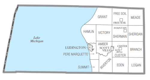
Communities in Mason County
Mason County has several different types of communities.
Cities
- Ludington (This is the main town, or county seat)
- Scottville
Villages
Charter Township
- Pere Marquette Charter Township
Civil Townships
- Amber Township
- Branch Township
- Custer Township
- Eden Township
- Free Soil Township
- Grant Township
- Hamlin Township
- Logan Township
- Meade Township
- Riverton Township
- Sheridan Township
- Sherman Township
- Summit Township
- Victory Township
Unincorporated Communities
These are smaller places that are not officially cities or villages.
- Branch (partially)
- Chapple Corners
- Fairview
- Fern
- Ferryville
- Tallman
- Walhalla
Native American Reservation
The Little River Band of Ottawa Indians is a recognized Odawa Native American tribe. They have a small reservation of about 740 acres within Custer Township. They also have another reservation in Brown Township, just north in Manistee County.
Education in Mason County
The West Shore Educational Service District is based in Ludington. It helps school districts in Mason County, as well as those in Lake and Oceana counties. This district offers special education, general education services, and technical career programs for students.
Mason County has several public school districts:
- Ludington Area School District
- Mason County Central Schools
- Mason County Eastern Schools
The county also has one charter school:
- Gateway to Success Academy
Mason County has the following private schools:
- Covenant Christian School (a Christian school)
- Ludington Area Catholic School (a Catholic school)
See also
 In Spanish: Condado de Mason (Míchigan) para niños


