
Meade County, South Dakota facts for kids
Quick facts for kids
Meade County
|
|
|---|---|

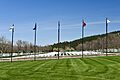
Black Hills National Cemetery
|
|

Location within the U.S. state of South Dakota
|
|
 South Dakota's location within the U.S. |
|
| Country | |
| State | |
| Founded | February 7, 1889 |
| Named for | George Meade |
| Seat | Sturgis |
| Largest city | Sturgis |
| Area | |
| • Total | 3,483 sq mi (9,020 km2) |
| • Land | 3,471 sq mi (8,990 km2) |
| • Water | 12 sq mi (30 km2) 0.3% |
| Population
(2020)
|
|
| • Total | 29,852 |
| • Estimate
(2023)
|
30,954 |
| • Density | 8.5708/sq mi (3.3092/km2) |
| Time zone | UTC−7 (Mountain) |
| • Summer (DST) | UTC−6 (MDT) |
| Congressional district | At-large |
Meade County is a county located in the state of South Dakota in the United States. In 2020, about 29,852 people lived there. This makes it the 6th largest county in South Dakota by population. The main town, or county seat, is Sturgis.
Meade County was started in 1889. It was named after Fort Meade, a military base from 1878. The fort itself was named after General George Meade. Meade County is also part of the larger Rapid City area.
Contents
Exploring Meade County's Geography
Meade County is a very large area. In fact, it is the biggest county in South Dakota by land size! It covers about 3,483 square miles. Most of this (3,471 square miles) is land, and a small part (12 square miles) is water.
Rivers, Hills, and Mountains
The northern part of Meade County has a stream called Cherry Creek. The Cheyenne River flows along the southeastern edge of the county. The western and southwestern parts of the county have mountain ridges. The rest of the county has rolling hills that are quite dry. Some of this land is used for farming. The highest point in the county is Flagstaff Mountain. It is about 5,421 feet (1,652 meters) above sea level.
Main Roads and Highways
Many important roads run through Meade County. These roads help people travel and connect different communities.
 Interstate 90
 U.S. Highway 14
- U.S. Highway 14A
 U.S. Highway 212
 South Dakota Highway 34
 South Dakota Highway 73
 South Dakota Highway 79
Neighboring Counties
Meade County shares its borders with several other counties in South Dakota.
- Perkins County - to the north
- Ziebach County - to the east
- Haakon County - to the southeast
- Pennington County - to the south
- Lawrence County - to the southwest
- Butte County - to the northwest
Parks and Natural Areas
Meade County is home to several beautiful natural areas and protected lands. These places offer opportunities for outdoor activities and help protect wildlife.
- Bear Butte Lake State Lakeside Use Area
- Bear Butte National Wildlife Refuge
- Bear Butte State Park
- Black Hills National Cemetery
- Black Hills National Forest (part of it)
- Curlew Lake State Game Production Area
- Marcotte State Game Production Area
- Tisdale Lake State Game Production Area
- Opal Lake State Game Production Area
Lakes in Meade County
You can find several lakes within Meade County.
- Bear Butte Lake
- Curlew Lake
- Durkee Lake
- Opal Lake
- Tisdale Dam
Meade County's Population Story
| Historical population | |||
|---|---|---|---|
| Census | Pop. | %± | |
| 1890 | 4,640 | — | |
| 1900 | 4,907 | 5.8% | |
| 1910 | 12,640 | 157.6% | |
| 1920 | 9,367 | −25.9% | |
| 1930 | 11,482 | 22.6% | |
| 1940 | 9,735 | −15.2% | |
| 1950 | 11,516 | 18.3% | |
| 1960 | 12,044 | 4.6% | |
| 1970 | 16,618 | 38.0% | |
| 1980 | 20,717 | 24.7% | |
| 1990 | 21,878 | 5.6% | |
| 2000 | 24,253 | 10.9% | |
| 2010 | 25,434 | 4.9% | |
| 2020 | 29,852 | 17.4% | |
| 2023 (est.) | 30,954 | 21.7% | |
| U.S. Decennial Census 1790-1960 1900-1990 1990-2000 2010-2020 |
|||
The number of people living in Meade County has changed over many years. The chart above shows how the population has grown since 1890.
Who Lives in Meade County?
In 2020, there were 29,852 people living in Meade County. There were 11,365 households, which are groups of people living together. The population density was about 8.6 people for every square mile.
In 2010, the county had 25,434 people. Most people (92%) were white. About 2.3% were American Indian, and 1.3% were Black or African American. About 3% of the population was of Hispanic or Latino background. Many people in Meade County have German, Irish, or Norwegian family backgrounds.
Towns and Communities
Meade County has several cities, one town, and other smaller communities.
Cities in Meade County
Town in Meade County
- Buffalo Chip
Special Census Areas
These are places where people live, but they are not officially cities or towns.
- Blackhawk
- Blucksberg Mountain
- Ellsworth AFB (used to be a census area)
- Wonderland Homes
Smaller Communities
Meade County also has many smaller, unincorporated communities.
Local Divisions
Meade County is divided into smaller areas called townships and unorganized territories.
- Dakota
- Eagle
- Elm Springs
- Howard
- Lakeside
- Smithville
- Upper Red Owl
Unorganized Territories
- Belle Fourche-Cheyenne Valleys
- North Meade
- Southwest Meade
Learning in Meade County: Schools
Meade County has several school districts. These districts help provide education for children and teens living in the area.
- Douglas School District 51-1
- Faith School District 46-2
- New Underwood School District 51-3
- Newell School District 09-2
- Rapid City School District 51-4
- Meade School District 46-1
- Wall School District 51-5
Images for kids
-
Black Hills National Cemetery
See also
 In Spanish: Condado de Meade (Dakota del Sur) para niños
