Milltown, New Jersey facts for kids
Quick facts for kids
Milltown, New Jersey
|
||
|---|---|---|
|
Borough
|
||
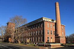
The historic Milltown India Rubber Factory, now converted to condominiums
|
||
|
||
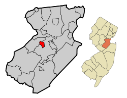
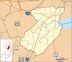
Location of Milltown in Middlesex County highlighted in red (left). Inset map: Location of Middlesex County in New Jersey highlighted in orange (right).
|
||

Census Bureau map of Milltown, New Jersey
|
||
| Country | ||
| State | ||
| County | Middlesex | |
| Incorporated | January 29, 1889 | |
| Government | ||
| • Type | Borough | |
| • Body | Borough Council | |
| Area | ||
| • Total | 1.59 sq mi (4.13 km2) | |
| • Land | 1.55 sq mi (4.02 km2) | |
| • Water | 0.04 sq mi (0.11 km2) 2.56% | |
| Area rank | 441st of 565 in state 22nd of 25 in county |
|
| Elevation | 36 ft (11 m) | |
| Population
(2020)
|
||
| • Total | 7,037 | |
| • Estimate
(2023)
|
6,968 | |
| • Rank | 317th of 565 in state 22nd of 25 in county |
|
| • Density | 4,528.3/sq mi (1,748.4/km2) | |
| • Density rank | 129th of 565 in state 10th of 25 in county |
|
| Time zone | UTC−05:00 (Eastern (EST)) | |
| • Summer (DST) | UTC−04:00 (Eastern (EDT)) | |
| ZIP Code |
08850
|
|
| Area code(s) | 732 | |
| FIPS code | 3402346620 | |
| GNIS feature ID | 0885303 | |
Milltown is a small town, called a borough, located in Middlesex County, New Jersey. It's in the middle of the Raritan Valley region. A stream called Lawrence Brook flows right through the town. In 2020, about 7,037 people lived here.
Milltown became an official borough on January 29, 1889. It was formed from parts of North Brunswick. Later, in 1902, a piece of East Brunswick Township was added. The town was first known as Bergen's Mill, named after Jacob I. Bergen, who owned a gristmill there. People started calling it "Milltown" because they would "go to the mill in town."
Contents
History
Long ago, before Europeans arrived, the Lenape Native Americans lived along the Lawrence Brook. Many old tools and items found near the town hall suggest they had a settlement there.
In 1678, a baker from New York named Thomas Lawrence bought a large area around the Lawrence Brook. This area likely included what is now Milltown. The brook was then called Piscopeek. Later, in 1769, a large gristmill was advertised for sale on the bank of Lawrence Brook. It became known as Lawrence Brook Mill.
Did you know that a famous early western film called The Great Train Robbery was filmed in Milltown in 1903?
After World War I, special travel guides for the battlefields in Europe were printed in Milltown.
A medicine called Miltown (meprobamate), used to help people relax, was developed in the mid-1950s. It was named after the borough of Milltown.
Geography
Milltown covers about 1.60 square miles (4.13 square kilometers). Most of this is land, with a small part being water.
The borough shares its borders with North Brunswick to the west and East Brunswick to the east.
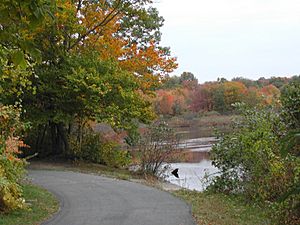
The Lawrence Brook flows through Milltown. This brook is a smaller stream that flows into the Raritan River. The brook flows out of Farrington Lake. A dam under Main Street creates a small lake called the Mill Pond.
Climate
Milltown has a climate with hot, humid summers and generally cold winters. This type of climate is known as a humid continental climate.
Population Information
| Historical population | |||
|---|---|---|---|
| Census | Pop. | %± | |
| 1900 | 561 | — | |
| 1910 | 1,584 | 182.4% | |
| 1920 | 2,573 | 62.4% | |
| 1930 | 2,994 | 16.4% | |
| 1940 | 3,515 | 17.4% | |
| 1950 | 3,786 | 7.7% | |
| 1960 | 5,435 | 43.6% | |
| 1970 | 6,470 | 19.0% | |
| 1980 | 7,136 | 10.3% | |
| 1990 | 6,968 | −2.4% | |
| 2000 | 7,000 | 0.5% | |
| 2010 | 6,893 | −1.5% | |
| 2020 | 7,037 | 2.1% | |
| 2023 (est.) | 6,968 | 1.1% | |
| Population sources: 1900–1920 1900–1910 1910–1930 1940–2000 2000 2010 2020 |
|||
What the 2010 Census Showed
In 2010, there were 6,893 people living in Milltown. There were 2,599 households, which are groups of people living together.
Most of the people (about 92%) were White. There were also people who identified as Black or African American, Native American, Asian, and people from other backgrounds. About 6.5% of the population was Hispanic or Latino.
About 21.8% of the people were under 18 years old. About 14.8% were 65 years or older. The average age in Milltown was about 41.6 years.
Education
Milltown has its own public school system called the Milltown Public Schools. Students from pre-kindergarten up to eighth grade attend these schools. There are two schools in the district:
- Parkview School, for students in Pre-K through 3rd grade.
- Joyce Kilmer School, for students in 4th through 8th grade.
For high school, students from Milltown go to Spotswood High School in Spotswood. This is part of a special agreement between the two school districts. Students from Helmetta also attend Spotswood High School.
There is also a charter school called the Greater Brunswick Charter School. It serves students from kindergarten to 8th grade, including those from Milltown and nearby towns like Edison and New Brunswick.
Students in 8th grade from all over Middlesex County can apply to special high school programs. These are offered by the Middlesex County Vocational and Technical Schools. They provide training in different careers and technical skills.
Transportation
Roads and Highways
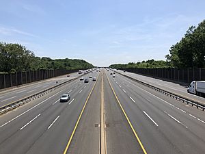
Milltown has about 27 miles of roads. Most of these are maintained by the town itself. A major road called Ryders Lane (County Route 617) runs along the eastern edge of the borough.
The New Jersey Turnpike (Interstate 95) passes through Milltown for about a mile. However, the closest exit to get on or off the Turnpike is in the neighboring town of East Brunswick. Also, a big highway called US 1 is nearby in North Brunswick.
Public Transportation
If you need to travel by bus, NJ Transit offers local bus service on the 811 route during weekdays.
There is also a bus service called Coach USA Suburban Transit that provides rides to New York City during busy morning and evening hours.
The old Raritan River Railroad used to run through Milltown. While it's no longer used for trains in this area, the tracks and an old freight station are still there. Some people have suggested using this old line for a light rail system in the future.
Notable People
Many interesting people have connections to Milltown. Here are a few:
- J. Edward Crabiel (1916–1992), a politician who served in the New Jersey Senate.
- Josephine Figlo (1923–2011), a professional baseball player in the All-American Girls Professional Baseball League.
- Al Hermann (1899–1980), a Major League Baseball player.
- David Kikoski (born 1961), a talented jazz pianist.
- Leroy Lins (1913–1986), a professional basketball player.
- Danny Pintauro (born 1976), an actor who started as a child in TV shows like Who's the Boss? and movies like Cujo.
- David Schwendeman (1924–2012), who was the main taxidermist at the American Museum of Natural History for many years.
- Geno Zimmerlink (born 1963), a former professional American football player for the Atlanta Falcons.
See also
 In Spanish: Milltown (Nueva Jersey) para niños
 | Laphonza Butler |
 | Daisy Bates |
 | Elizabeth Piper Ensley |


