Montgomery County, Mississippi facts for kids
Quick facts for kids
Montgomery County
|
|
|---|---|

U.S. Post Office in Winona.
|
|

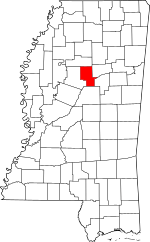
Location within the U.S. state of Mississippi
|
|
 Mississippi's location within the U.S. |
|
| Country | |
| State | |
| Founded | 1871 |
| Seat | Winona |
| Largest city | Winona |
| Area | |
| • Total | 408 sq mi (1,060 km2) |
| • Land | 407 sq mi (1,050 km2) |
| • Water | 0.9 sq mi (2 km2) 0.2% |
| Population
(2020)
|
|
| • Total | 9,822 |
| • Density | 24.074/sq mi (9.295/km2) |
| Time zone | UTC−6 (Central) |
| • Summer (DST) | UTC−5 (CDT) |
| Congressional district | 2nd |
Montgomery County is a county in the state of Mississippi. In 2020, about 9,822 people lived here. The main town and county seat is Winona.
The county's name might come from Richard Montgomery. He was an American general who died in 1775 during the American Revolutionary War. Another idea is that it was named after Montgomery County, Tennessee. An early settler came from there. That county was named after John Montgomery, who started the city of Clarksville, Tennessee.
The Big Black River flows through the southern part of Montgomery County. It goes southwest to join the Mississippi River near Vicksburg.
Contents
Exploring Montgomery County's Land and Roads
Where is Montgomery County?
Montgomery County covers about 408 square miles. Most of this area, 407 square miles, is land. Only a small part, less than one square mile, is water. It is one of the smallest counties in Mississippi.
Main Roads in the County
Several important highways run through Montgomery County. These roads help people travel easily across the county and to other places.
 Interstate 55
 U.S. Route 51
 U.S. Route 82
Neighboring Counties
Montgomery County shares its borders with several other counties:
- Grenada County to the north
- Webster County to the northeast
- Choctaw County to the east
- Attala County to the south
- Carroll County to the west
A Look at Montgomery County's Past
This area was once home to the Choctaw people. Their ancestors lived here for thousands of years. In the 1830s, the United States government made most Native Americans move west. This was part of the Indian Removal Act. It opened up their lands for new settlers.
Before and after the Civil War, many cotton farms grew in Montgomery County. African Americans, who were enslaved before the war, did most of the work. The county officially started in 1871. This was during the Reconstruction era, after the Civil War. The eastern parts of the county became known for their timber industry.
From 1910 to 1920, and again from 1940 to 1970, fewer people lived in Montgomery County. The most people lived here in 1910. This change happened for a few reasons. Farming became more automated, so fewer workers were needed. Also, many Black Americans moved away from the South. This was called the Great Migration. They looked for better jobs and chances in other parts of the country. Because of this, Mississippi changed from having more Black residents in 1910 to more White residents by 1970.
People of Montgomery County
| Historical population | |||
|---|---|---|---|
| Census | Pop. | %± | |
| 1880 | 13,348 | — | |
| 1890 | 14,459 | 8.3% | |
| 1900 | 16,536 | 14.4% | |
| 1910 | 17,706 | 7.1% | |
| 1920 | 13,805 | −22.0% | |
| 1930 | 15,009 | 8.7% | |
| 1940 | 15,703 | 4.6% | |
| 1950 | 14,470 | −7.9% | |
| 1960 | 13,320 | −7.9% | |
| 1970 | 12,918 | −3.0% | |
| 1980 | 13,366 | 3.5% | |
| 1990 | 12,388 | −7.3% | |
| 2000 | 12,189 | −1.6% | |
| 2010 | 10,925 | −10.4% | |
| 2020 | 9,822 | −10.1% | |
| 2023 (est.) | 9,600 | −12.1% | |
| U.S. Decennial Census 1790-1960 1900-1990 1990-2000 2010-2013 |
|||
Population in 2020
In 2020, the county had 9,822 people. There were 4,539 households and 3,064 families.
| Race | Num. | Perc. |
|---|---|---|
| White (non-Hispanic) | 5,094 | 51.86% |
| Black or African American (non-Hispanic) | 4,364 | 44.43% |
| Native American | 9 | 0.09% |
| Asian | 24 | 0.24% |
| Other/Mixed | 225 | 2.29% |
| Hispanic or Latino | 106 | 1.08% |
Population in 2010
In 2010, there were 10,925 people living in the county. About 53% were White, and 45.5% were Black or African American. A small number of people were Asian, Native American, or of two or more races. About 0.9% of the people were Hispanic or Latino.
Learning in Montgomery County
Public Schools
- Winona-Montgomery Consolidated School District - This district was formed in 2018. It joined the Winona district and the Montgomery County School District.
Private Schools
- Winona Christian School
Towns and Communities
Cities
- Winona (This is the county seat, where the county government is located.)
Towns
Unincorporated Communities
These are smaller communities that are not officially towns or cities.
Ghost Town
- Middleton (A ghost town is a place where people used to live, but now it is mostly empty.)
Famous People from Montgomery County
- Fannie Lou Hamer - She was an important civil rights activist. She worked with the Mississippi Freedom Democratic Party in 1964. Fannie Lou Hamer was born in Montgomery County in 1917. She later moved to Sunflower County.
See also
 In Spanish: Condado de Montgomery (Misisipi) para niños

