Muscatine County, Iowa facts for kids
Quick facts for kids
Muscatine County
|
|
|---|---|

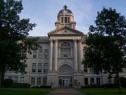
Muscatine County Courthouse in Muscatine
|
|

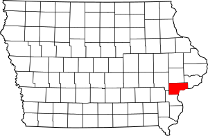
Location within the U.S. state of Iowa
|
|
 Iowa's location within the U.S. |
|
| Country | |
| State | |
| Founded | December 7, 1836 |
| Named for | Mascouten tribe |
| Seat | Muscatine |
| Largest city | Muscatine |
| Area | |
| • Total | 449 sq mi (1,160 km2) |
| • Land | 437 sq mi (1,130 km2) |
| • Water | 12 sq mi (30 km2) 2.6% |
| Population
(2020)
|
|
| • Total | 43,235 |
| • Estimate
(2023)
|
42,218 |
| • Density | 96.29/sq mi (37.18/km2) |
| Time zone | UTC−6 (Central) |
| • Summer (DST) | UTC−5 (CDT) |
| Congressional district | 1st |
Muscatine County is a county located in the state of Iowa in the United States. In 2020, about 43,235 people lived there. The main city, or "county seat," is Muscatine. The mighty Mississippi River forms the southeastern border of the county. Muscatine County is also part of the bigger Quad Cities region, which includes cities like Davenport and Moline.
Contents
History of Muscatine County
Muscatine County was created in December 1836. At that time, it was part of the Wisconsin Territory. It was formed from a section of Des Moines County.
Some people believe the county was named after Muscatine Island in the Mississippi River. This island was thought to be named after the Mascouten tribe. The Mascouten were Native Americans who spoke the Algonquian language. They lived in this area before new settlers arrived and other tribes moved in, causing them to move west.
Early European Settlers
In 1833, Colonel George Davenport from Illinois sent three people to the area. They were the first European Americans to settle there. That same year, James W. Casey and John Vanatta also arrived. On June 1, 1833, they opened a place to supply steamboats with wood. They called it Casey's Woodpile, because steamboats used wood for fuel.
Muscatine County became part of the Iowa Territory on July 4, 1838. This happened when the Iowa Territory was created from the Wisconsin Territory. The first public land sale in the county took place in November 1838.
Courthouse Buildings
One year after the land sale, officials started building the first courthouse and a jail. A second jail, known as the "Old Jail", was built in 1857.
The first courthouse was destroyed by fire on December 23, 1864. A new courthouse was built on the same spot by 1866. The current courthouse opened its doors on September 26, 1907.
Geography and Nearby Areas
Muscatine County covers a total area of about 449 square miles. Most of this area, about 437 square miles, is land. The remaining 12 square miles, which is about 2.6% of the county, is water.
Counties Next to Muscatine County
- Cedar County (to the north)
- Johnson County (to the northwest)
- Louisa County (to the south and southwest)
- Rock Island County, Illinois (to the east, across the Mississippi River)
- Scott County (to the northeast)
Transportation in Muscatine County
Local Bus Service
- MuscaBus provides bus services in the area.
Main Highways
 U.S. Highway 6 – This highway enters from Cedar County near Wilton. It then goes south, then west, and finally northwest, leaving the county into Johnson County.
 U.S. Highway 61 – This highway comes from Louisa County near Fruitland. It travels northeast through the county, passing Muscatine. Then it turns east to enter Scott County at Blue Grass.
 Iowa Highway 22 – This road starts near Nichols. It goes east and southeast to meet US 61, west of Muscatine.
 Iowa Highway 38 – This highway begins near Wilton at US 6. It goes south to meet US 61, north of Muscatine.
 Iowa Highway 70 – This road enters from Louisa County in the southwest part of Muscatine County. It travels north, northeast, and east towards Cedar County, passing through Nichols and West Liberty.
 Iowa Highway 92 - This highway enters Iowa and Muscatine County by crossing the Norbert F. Beckey Bridge into central Muscatine. It then goes southwest along the Mississippi River to meet US 61, southwest of Muscatine.
Other Important Roads
- Great River Road - This is a system of roads that runs north and south across the United States, generally passing through Iowa.
County Roads
- County Highway F58 (used to be Hwy 927)
- County Highway F62
- County Highway F65
- County Highway F70 (155th St)
- County Highway G14 (180th St)
- County Highway G28 (230th/231st Sts)
- County Highway G34 (275th St)
- County Highway G38 (Fruitland Rd)
- County Highway X34 (Davis Ave)
- County Highway X40 (Garfield Ave)
- County Highway X46 (Kelly Ave/170th St)
- County Highway X61 (Stewart Rd)
- County Highway Y14 (Taylor Ave)
- County Highway Y26 (Vail Ave)
- County Highway Y30 (Western Ave)
- County Highway Y36 (Zachary Ave)
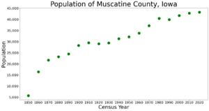
Population of Muscatine County
| Historical population | |||
|---|---|---|---|
| Census | Pop. | %± | |
| 1850 | 5,731 | — | |
| 1860 | 16,444 | 186.9% | |
| 1870 | 21,688 | 31.9% | |
| 1880 | 23,170 | 6.8% | |
| 1890 | 24,504 | 5.8% | |
| 1900 | 28,242 | 15.3% | |
| 1910 | 29,505 | 4.5% | |
| 1920 | 29,042 | −1.6% | |
| 1930 | 29,385 | 1.2% | |
| 1940 | 31,296 | 6.5% | |
| 1950 | 32,148 | 2.7% | |
| 1960 | 33,840 | 5.3% | |
| 1970 | 37,181 | 9.9% | |
| 1980 | 40,436 | 8.8% | |
| 1990 | 39,907 | −1.3% | |
| 2000 | 41,722 | 4.5% | |
| 2010 | 42,745 | 2.5% | |
| 2020 | 43,235 | 1.1% | |
| 2023 (est.) | 42,218 | −1.2% | |
| U.S. Decennial Census 1790-1960 1900-1990 1990-2000 2010-2018 |
|||
2020 Census Information
The 2020 census counted 43,235 people living in Muscatine County. This means there were about 96 people per square mile. Most people (92.12%) reported being of one race. There were 18,366 homes, and 16,908 of them were lived in.
| Race | Number of People | Percentage |
|---|---|---|
| White (not Hispanic) | 27,438 | 75.5% |
| Black or African American (not Hispanic) | 1,086 | 2.5% |
| Native American (not Hispanic) | 58 | 0.13% |
| Asian (not Hispanic) | 404 | 0.93% |
| Pacific Islander (not Hispanic) | 0 | 0% |
| Other/Mixed (not Hispanic) | 1,285 | 3% |
| Hispanic or Latino | 7,769 | 18% |
2010 Census Information
In 2010, the census recorded 42,745 people in the county. There were about 100 people per square mile. There were 17,910 homes, and 16,412 of them were lived in.
Cities and Towns in Muscatine County
Cities
- Atalissa
- Blue Grass (partly in another county)
- Conesville
- Durant (partly in other counties)
- Fruitland
- Muscatine
- Nichols
- Stockton
- Walcott (partly in another county)
- West Liberty
- Wilton
Other Communities (Census-designated places)
These are areas that are like towns but are not officially incorporated as cities.
- Fairport
- Kent Estates
- Montpelier
- Moscow
Small Unincorporated Communities
These are even smaller communities that are not officially part of any city or town.
Townships
Townships are smaller divisions of a county, often used for local government.
- Bloomington
- Cedar
- Fruitland
- Fulton
- Goshen
- Lake
- Montpelier
- Moscow
- Orono
- Pike
- Seventy-Six
- Sweetland
- Wapsinonoc
- Wilton
Population Ranking of Cities and Towns (2020 Census)
This list shows the cities and towns in Muscatine County, from largest to smallest by population.
† This symbol means it is the county seat, or the main city of the county.
| Rank | City/Town/Community | Type | Population (2020 Census) |
|---|---|---|---|
| 1 | † Muscatine | City | 23,797 |
| 2 | West Liberty | City | 3,858 |
| 3 | Wilton (partly in Cedar County) | City | 2,924 |
| 4 | Durant (mostly in Scott and Cedar Counties) | City | 1,871 |
| 5 | Blue Grass (mostly in Scott County) | City | 1,666 |
| 6 | Walcott (partly in Scott County) | City | 1,551 |
| 7 | Fruitland | City | 963 |
| 8 | Conesville | City | 352 |
| 9 | Nichols | City | 340 |
| 10 | Atalissa | City | 296 |
| 11 | Stockton | City | 176 |
See also
 In Spanish: Condado de Muscatine para niños
 | Aurelia Browder |
 | Nannie Helen Burroughs |
 | Michelle Alexander |


