
Narmada River facts for kids
Quick facts for kids Narmada |
|
|---|---|

At Bhedaghat in Jabalpur, India
|
|
 
Maps showing the course of the Narmada, selected tributaries, and the approximate extent of its drainage area
|
|
| Country | India |
| State | Madhya Pradesh, Maharashtra, Gujarat |
| City | Narmadapuram, Budhni, Jabalpur, Dindori, Narsinghpur Harda, Mandhata, Omkareshwar, Barwaha, Mandleshwar, Maheshwar, Mandla, Bharuch, Rajpipla, Sinor (Vadodara District), Dabhoi (Vadodara District), Karjan (Vadodara District), Dharampuri |
| Physical characteristics | |
| Main source | Narmada Kund Vindhyachal Parvat Amarkantak Plateau, Anuppur district, Central India, Madhya Pradesh 1,048 m (3,438 ft) 22°40′0″N 81°45′0″E / 22.66667°N 81.75000°E |
| River mouth | Gulf of Khambhat (Arabian Sea) Bharuch District, Gujarat 0 m (0 ft) 21°39′3.77″N 72°48′42.8″E / 21.6510472°N 72.811889°E |
| Length | 1,312 km (815 mi)approx. |
| Depth |
|
| Discharge (location 2) |
|
| Basin features | |
| Tributaries |
|
The Narmada River, also known as the Reva, is one of India's most important rivers. It is the 5th longest river in the country. It is also the longest river in India that flows from east to west. The Narmada flows through the states of Madhya Pradesh and Gujarat. People often call it the "Life Line of Madhya Pradesh and Gujarat." This is because it helps these states in many ways.
The Narmada River starts from the Amarkantak Plateau in the Anuppur district of Madhya Pradesh. It acts as a natural border between North India and South India. The river flows west for about 1,312 km (815 mi) before reaching the Arabian Sea. It empties into the Gulf of Khambhat, which is about 30 km (19 mi) west of Bharuch city in Gujarat.
The Narmada is special because it flows through a rift valley. This means it runs in a deep crack in the Earth's crust. It flows between the Satpura and Vindhya mountain ranges. Unlike most rivers, the Narmada does not form a delta at its mouth. Instead, it forms an estuary, which is where the river meets the sea. Other rivers like the Tapti River also flow through rift valleys. The Narmada flows for about 1,077 km (669 mi) in Madhya Pradesh. It then flows along the border of Madhya Pradesh and Maharashtra for 39 km (24 mi). After that, it flows along the border of Maharashtra and Gujarat for 74 km (46 mi). Finally, it flows for 161 km (100 mi) within Gujarat.
Ancient texts and maps mention the Narmada River. For example, a very old sailing guide from around 80 AD called it the Namnadius. The British also called it the Nerbudda or Narbada. The word Narmada comes from Sanskrit, meaning "The Giver of Pleasure."
Contents
River's Journey


The Narmada River starts from a small pool called the Narmada Kund. This pool is located at Amarkantak on the Amarkantak Plateau in Madhya Pradesh. From there, the river flows down a cliff, forming the Kapildhara waterfall. It then winds through hills and rocky areas.
Near the city of Jabalpur, the river drops about 9 m (30 ft). This creates a beautiful waterfall called the Dhuandhar Falls, which means "fall of mist." After this waterfall, the Narmada flows through a narrow channel for about 3 km (1.9 mi). This channel is carved through stunning magnesium limestone and basalt rocks. These rocks are known as the Marble Rocks. Above the falls, the river is about 90 m (300 ft) wide. But in this channel, it squeezes into a space only 18 m (59 ft) wide!
Beyond the Marble Rocks, the Narmada enters its first fertile valley. This valley stretches for about 320 km (200 mi). Many important rivers join the Narmada here from the south. These include the Sher, Shakkar, Dudhi, and the Tawa, which is the biggest tributary. From the north, rivers like the Hiran and Barna join it.
Further downstream, the river flows between hills. Omkareshwar, a holy place for Shiva worship, is located here. The river then enters another wide plain called the Mandleshwar plain. As it continues west, the Narmada flows through the rich plains of the Bharuch district in Gujarat. Near Bharuch, the river becomes very wide, about 3 km (1.9 mi). At its mouth, where it meets the Gulf of Cambay, it forms an estuary that is about 21 km (13 mi) wide.
The Narmada is deep enough for small boats to travel on it. Larger vessels can go up to Bharuch. A famous spot on the river is the island of Kabirvad. It has a giant Banyan tree that covers a huge area of 10,000 square metres (2.5 acres).
Narmada River Basin

The Narmada River basin is the area of land drained by the river and its tributaries. It is located between the Vindhya and Satpura mountain ranges. This basin covers a large area of about 98,796 km2 (38,145 sq mi). Most of it is in Madhya Pradesh (82%), with smaller parts in Gujarat (12%), Maharashtra (4%), and Chhattisgarh (2%).
About 60% of the basin is farmland, while 35% is covered by forests. The Narmada River has 41 tributaries, which are smaller rivers or streams that flow into it. Twenty-two of these come from the Satpura range, and the rest come from the Vindhya range. The highest point in the Narmada basin is Dhupgarh, which is 1,350 metres (4,430 ft) high.
The basin has different types of landscapes. There are hilly areas, wide plains suitable for farming, and coastal plains near the sea. The soil in the Narmada basin is mostly black soil. The weather in the basin varies a lot. The upper parts get a lot of rain, while the lower parts get much less. This difference in rainfall leads to different types of forests, from lush green to dry forests.
How the Narmada Valley Formed
Millions of years ago, the Earth's continents looked very different. A supercontinent called Gondwana existed in the south. Over time, the Earth's crust moved and changed. A deep crack or "graben" formed along what is now the Narmada Valley. This graben is a block of the Earth's crust that dropped down. It is bordered by two faults (cracks in the Earth's crust) that run parallel to the river. These faults separate the Narmada block from the higher Vindhya and Satpura blocks.
This unique geological formation explains why the Narmada River flows from east to west. It also explains why it doesn't form a delta like many other rivers. Scientists have found ancient animal remains, like Dinosaur fossils, in the Narmada Valley. The first fossil was found in 1828. In 1982, fossil remains of a dinosaur called Rajasaurus narmadensis were discovered here. This dinosaur lived during the Cretaceous Period, millions of years ago.
Importance in Hinduism


In Hinduism, the Narmada River is considered a very sacred river, just like the Ganges. Many Hindu texts say that all the banks along the Narmada are holy.
There are several stories about how the Narmada River came to be. One legend says that the Narmada was created from the sweat of the god Shiva while he was meditating. Because of this, the Narmada River is often called Shiva's daughter. Another story says that two teardrops fell from the eyes of Brahma, the creator god, and these tears formed the Narmada and the Son rivers.
The Narmada is also special because of unique pebbles found in its riverbed. These pebbles are called banalingas. They are made of white quartz and are shaped like a linga, which is a symbol of Shiva. People believe that Shiva himself lives in these pebbles. There's a popular saying: "Narmada Ke Kanker utte Sankar," meaning "Shiva is in the pebbles of Narmada."
Many important religious sites are located along the Narmada. For example, the great philosopher Adi Shankara met his teacher in Omkareshwar, a town on the river's banks. The Narmada is also known as Reva, which means "leaping motion," because of how it flows quickly over its rocky bed. People also worship the Narmada as the mother goddess Muktidayani, meaning "liberating mother."
Many pilgrims undertake a holy journey called a parikrama, or circumambulation, around the Narmada River. This involves walking on foot along the river's banks from the Arabian Sea all the way to its source in the Amarkantak hills and back along the opposite bank. This long walk is about 2,600-kilometre (1,600 mi) and is considered a very spiritual act. It usually takes about 3 years, 3 months, and 13 days. During this journey, pilgrims are not supposed to cross the river. Many important towns and temples are visited during this pilgrimage.
Nature and Wildlife


The Narmada River Valley and the surrounding areas are home to dry deciduous forests. These forests are found between wetter forests and drier areas. The natural plants in this region grow in three layers. The main trees are Teak (Tectona grandis), along with others like Diospyros melanoxylon and Terminalia tomentosa. Along the rivers and streams, where there is water all year, you can find moist evergreen forests with trees like Terminalia arjuna and Syzygium cumini.
The Narmada region is home to 76 types of mammals and 276 kinds of birds. About 30% of the area still has its natural vegetation. There are also several protected areas here, including Bandhavgarh, Panna, and Sanjay National Parks.
Some important national parks and wildlife sanctuaries in the Narmada Valley include:
- Kanha National Park: Located near Mandla, this park is famous for its wild animals, especially Tigers. Two Narmada tributaries, Sulkum and Banjar, flow through it. This park is considered one of the best in Asia and inspired Rudyard Kipling's famous book, The Jungle Book.
- Satpura National Park: Established in 1981 in the Narmadapuram district, this park is named after the Satpura hills. It covers 524 km2 (202 sq mi) and is part of a unique ecosystem. It has a rich variety of animals like tigers, leopards, sambar, chital, nilgai, wild boar, wild dog, and sloth bear. Common birds include Hornbills and peafowl. The park's plants include sal, teak, and various medicinal plants.
- Mandla Plant Fossils National Park: Located in the Dindori district, this park protects plant fossils that are between 40 million and 150 million years old. These fossils show what plants looked like in ancient India.
- Pachmarhi Biosphere Reserve: This large reserve covers parts of three districts and includes the Bori Sanctuary, Satpura National Park, and Pachmarhi Sanctuary. It is one of the oldest forest reserves in India and is known for its wide variety of plants and animals.
Other natural preserves include Amarkantak, the Bagh Caves, and Bhedaghat. There is also the Shoolpaneshwar Sanctuary in Gujarat, which is home to many mammals and birds like eagles and hawks.
Ancient Discoveries
The development of the Narmada River, especially with dams, has sometimes covered up old archaeological sites. To save these important places, the government has moved some temples and tried to record all the sites that might be lost.
As mentioned before, many Dinosaur fossils have been found in the Narmada valley. These discoveries help us learn about the ancient creatures that lived here millions of years ago.
River Development Projects
The Narmada River has a huge amount of water. More than 90% of its water flows during the monsoon months (June to September). This water can be used for many purposes, like irrigation and generating electricity.
Sardar Sarovar Dam
The Sardar Sarovar Dam is the largest of about 30 dams planned on the Narmada River. It is the second-largest concrete dam in the world based on the amount of concrete used to build it. This dam is part of a big project called the Narmada Valley Project. This project aims to build many dams to provide water for irrigation and create hydroelectricity (power from water).
The dam's height has been a topic of discussion for many years. After several court cases, the final height was approved to be 163 m (535 ft) from its foundation.
Water Sharing Challenges
Plans to use the Narmada's water started as early as 1945. However, different states had different ideas about how to use the water. This led to conflicts between the states of Madhya Pradesh, Gujarat, and Maharashtra because there wasn't enough water to meet everyone's plans.
To solve these disagreements, the Government of India set up the Narmada Water Disputes Tribunal (NWDT) in 1968. This group was created to decide how the water should be shared fairly. After ten years, in 1978, the Tribunal made its decision.

Even after the Tribunal's decision, there were still challenges, especially regarding the height of the Sardar Sarovar Dam and how people affected by the dam would be resettled. A social movement called Narmada Bachao Andolan (NBA) was formed. This group raised concerns about the environment and the need to properly resettle people whose homes would be flooded by the dam. Their efforts brought worldwide attention to the project.
Eventually, the Supreme Court of India also looked into the matter. In 2000, after many years, the Court supported the Tribunal's decision and allowed the dam construction to continue. However, it also put in place a system to make sure that people were resettled properly as the dam's height increased.
Narmada Canal

The Narmada Canal is a long canal that carries water from the Sardar Sarovar Dam to the states of Gujarat and Rajasthan. The canal is 532 kilometres (331 mi) long. It helps bring water to dry areas like Kutch and Saurashtra for farming. By 2010, the Narmada canal had reached over 68% of the planned villages in Gujarat, helping many farmers.
Indirasagar Dam

The Indira Sagar Project (ISP) is another major dam project on the Narmada River. It is located near Punasa village in Madhya Pradesh. This project has the largest water storage capacity in India. The dam is 653 metres (2,142 ft) long and 92 metres (302 ft) high.
The Indira Sagar Dam helps irrigate about 1,690 km2 (650 sq mi) of land. It also generates 1000 MW of hydroelectricity. Additionally, it provides 60,000 acre⋅ft (74,000,000 m3) of drinking water to rural areas in the Khandwa district. The dam and its powerhouse are complete, and electricity generation started in January 2004. The irrigation part of the project is also well underway.
Images for kids
-
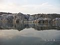
Marble rocks alongside Narmada River
-
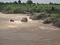
Narmada River at full flow during monsoon in Bhedaghat.
.jpg)

See also
 In Spanish: Río Narmada para niños
- List of rivers of India
- Narmada Pushkaram
- 3rd Narmada Bridge
- Bhadbhut barrage
