
National Register of Historic Places listings in Penobscot County, Maine facts for kids

Have you ever wondered about the old buildings and special places in your town? Many of these places have amazing stories! The National Register of Historic Places is like a special list that helps protect important buildings, sites, and objects across the United States. When a place is on this list, it means it's super important to history, architecture, or even archeology.
In Penobscot County, Maine, there are over 100 places on this list! These spots tell us a lot about Maine's past, from old libraries and churches to unique homes and even places where important events happened. Let's explore some of these cool historic spots!
Contents
What are Historic Places?
The National Register of Historic Places is managed by the National Park Service. It's the official list of places that are worth saving because of their historical value. Think of it like a hall of fame for buildings and sites! When a place is added, it gets recognized for its importance. This can help protect it and sometimes even provide money for its care.
These places can be:
- Buildings: Like old houses, schools, or churches.
- Sites: Such as battlefields or archeological digs.
- Structures: Like bridges or monuments.
- Objects: Such as sculptures.
- Districts: A group of buildings or sites that are historically connected.
Penobscot County has many different types of historic places. Some are well-known landmarks, while others are hidden gems that tell a unique part of the county's story.
Cool Historic Spots in Penobscot County
Let's take a closer look at some of the interesting places listed on the National Register in Penobscot County.
Famous Buildings in Bangor
Bangor, Maine is the largest city in Penobscot County and has many historic buildings.
- Abbott Memorial Library: Located in Dexter, Maine, this beautiful library was added to the list in 1978. It's a place where people have gone to read and learn for many years.
- Adams-Pickering Block: This building in Bangor, found at the corner of Main and Middle Streets, became historic in 1974. It's a great example of old city architecture.
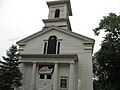
- All Souls Congregational Church: This church at 10 Broadway in Bangor has been a landmark since 1992. It's a place of worship with a rich history.

- Bangor Children's Home: This building on Ohio Street in Bangor was listed in 1975. It once served as a home for children, showing how communities cared for their young ones in the past.
- Bangor Fire Engine House No. 6: Found on Center Street, this old fire station was added in 1988. Imagine the horse-drawn fire engines that might have rushed out of here!

- Bangor House: Located on Main Street, this historic hotel was listed in 1972. It was a popular spot for travelers and important events in Bangor's history.

- Bangor Standpipe (Thomas Hill Standpipe): This tall water tower on Jackson Street in Bangor was recognized in 1974. It's not just a water tower; it's a cool piece of engineering and a city icon.
- Bangor Theological Seminary Historic District: This area on Union Street in Bangor became a historic district in 1977. It includes several buildings that were part of an important seminary.

- Battleship Maine Monument: At the junction of Main and Cedar Streets in Bangor, this monument was listed in 1999. It honors the USS Maine, a ship whose sinking helped start the Spanish-American War.
- Blake House: This house on Court Street in Bangor was added in 1972. Many old homes on the list show us how people lived long ago.
- Broadway Historic District: This large area in Bangor, bounded by several streets, was recognized in 1973. It's a neighborhood filled with historic homes and buildings.
- Charles G. Bryant Double House: This unique double house on Division Street in Bangor was listed in 1986. It's an interesting example of shared living spaces from the past.

- Building at 84-96 Hammond Street: This building in Bangor was added in 2005. It's part of the city's downtown history.

- Colonial Apartments: These apartments on High Street in Bangor were listed in 2012. They represent a style of living from a different era.

- Connors House: This house on State Street in Bangor was added in 1983. It's another example of a well-preserved historic home.

- Samuel Farrar House: On Court Street in Bangor, this house was listed in 1974. It's a beautiful old home with a story to tell.
- Godfrey-Kellogg House: This house on Kenduskeag Avenue in Bangor was added in 1973. It's a grand old residence.

- Grand Army Memorial Home: Located on Union Street in Bangor, this building was listed in 1972. It's also known as the Thomas A. Hill House and served as a meeting place for Civil War veterans.

- Great Fire of 1911 Historic District: This district in downtown Bangor was recognized in 1984. It includes buildings rebuilt after a huge fire in 1911, showing the city's resilience.
_Bangor,_Maine.JPG)
- Hannibal Hamlin House: This house on 5th Street in Bangor was listed in 1979. Hannibal Hamlin was a very important person – he was Abraham Lincoln's Vice President!

- Hammond Street Congregation Church: This church at Hammond and High Streets in Bangor was added in 1982. It's a beautiful example of church architecture.

- Charles W. Jenkins House: On Pine Street in Bangor, this house was listed in 1990. It's another historic home that helps tell Bangor's story.

- Jonas Cutting-Edward Kent House: This house on Penobscot Street in Bangor was added in 1973. It has a long history connected to important people.
- Joseph W. Low House: On Highland Street in Bangor, this house was listed in 1973. It's a classic example of historic residential architecture.
- Morse & Co. Office Building: This office building on Harlow Street in Bangor was recognized in 1973. It was once a busy place for business.

- Mount Hope Cemetery District: This cemetery on US Route 2 in Bangor was added in 1974. It's a historic burial ground with beautiful old monuments.

- St. John's Catholic Church: This church on York Street in Bangor was listed in 1973. It's a significant religious building in the city.

- Sargent-Roberts House: This house on State Street in Bangor was added in 1996. It's another example of a well-preserved historic home.

- Zebulon Smith House: On Summer Street in Bangor, this house was listed in 1974. It's a historic residence that adds to the city's charm.

- Symphony House: This house on Union Street in Bangor was recognized in 1972. It's also known as the Isaac Farrar Mansion and is now owned by the YMCA.

- Wardwell-Trickey Double House: This double house on Ohio Street in Bangor was listed in 1992. It's a unique architectural style.

- West Market Square Historic District: This area in Bangor was added in 1979. It's a lively part of downtown with many historic buildings.

- Wheelwright Block: This building on Hammond Street in Bangor was listed in 1974. It's part of the historic downtown area.

- Whitney Park Historic District: This district in Bangor, roughly bounded by 8th, Union, Pond, and Hayford Streets, was recognized in 1988. It's a neighborhood with many historic homes.
- Gen. John Williams House: This house on High Street in Bangor was listed in 1978. It was once home to a significant general.

Historic Places Around Penobscot County
Penobscot County has many other interesting historic sites outside of Bangor.
- Harold Allan Schoolhouse: This old schoolhouse on Rebel Hill Road in Clifton, Maine was listed in 2008. It reminds us of how schools used to be.
- Bodwell Water Power Company Plant: Located on the Penobscot River in Milford, Maine, this power plant was added in 1988. It shows how people used natural resources for energy.
- Bradford Farm Historic District: This district on Main Street in Patten, Maine was recognized in 2003. It's now a bed and breakfast, so you can even stay in a historic place!
- Brewer High School (Old): The old high school building on Somerset Street in Brewer, Maine was listed in 2014. Many generations of students learned here.

- Louis I. Bussey School: This school on US Route 202 in Dixmont, Maine was added in 1976. It's another example of a historic school building.
- Cliffwood Hall: Also on Rebel Hill Road in Clifton, this hall was listed in 2008. It's a historic community building.
- William Colburn House: This house on Bennoch Road in Orono, Maine was added in 1973. It's a historic home in the university town.
- Congregational Church of Medway: This church off State Route 11 in Medway, Maine was listed in 1977. It's a historic place of worship for the community.
- Corinth Town Hall and Corinthian Lodge No. 59, I.O.O.F.: This building on Main Street in Corinth, Maine was recognized in 2008. It served as both a town hall and a lodge.

- Corinth Village: This village area west of East Corinth was added as a historic district in 1973. It's a collection of historic buildings.
- John B. Curtis Free Public Library: This library in Bradford, Maine was listed in 1997. It's a community hub for reading and learning.
- Abial Cushman Store: This old store on Main Street in Lee, Maine was added in 1990. It was once a central place for shopping in the town.
- Dexter Grist Mill: This mill on State Route 7 in Dexter, Maine was recognized in 1975. Grist mills were important for grinding grain into flour.
- Dexter Universalist Church: This church on Church Street in Dexter was listed in 1985. It's a historic religious building.
- District No. 2 School: This school in Passadumkeag, Maine was added in 1997. It's a small, historic schoolhouse.

- District No. 5 School House: Located on Billings Road in Hermon, Maine, this schoolhouse was listed in 1997.
- Dixmont Corner Church: This church on US Route 202 in Dixmont, Maine was recognized in 1983. It's a charming old church.

- Dixmont Town House: This town house on Western Avenue in Dixmont was added in 2014. It's where town meetings and events happened.
- East Eddington Public Hall: This hall on Airline Road in Eddington, Maine was listed in 2004. It was a place for community gatherings.

- Enterprise Grange, No. 173: This building on Dow Road in Orrington, Maine was recognized in 2008. Granges were important social and educational groups for farmers.
- Gordon Fox Ranch: This ranch on West Broadway in Lincoln, Maine was listed in 2015. It's a more recent addition to the historic register.
- Garland Grange Hall: This hall off State Route 94 in Garland, Maine was added in 1975. Another example of a historic Grange hall.
- Hexagon Barn: This unique barn at Spring and Railroad Streets in Newport, Maine was listed in 1980. Its hexagon shape makes it very special!
- Hirundo Site: This site in the Hirundo Wildlife Refuge in Old Town, Maine was recognized in 1975. It's an important archeological site.
- Holden Town Hall: This town hall on Main Road in Holden, Maine was added in 2014. It's a central part of the town's civic life.
- Romanzo Kingman House: This house on Main Street in Kingman, Maine was listed in 1982. It's a historic home in a small town.
- Martin Kinsley House: This house on Main Road South in Hampden Highlands was recognized in 1983. It's now home to the Hampden Historical Society!
- Jabez Knowlton Store: This store west of Newburgh, Maine on State Route 9 was added in 1978. It's now a private museum.
- Maine Experiment Station Barn: This barn on the University of Maine campus in Orono was listed in 1990. It's the main building of the Page Farm & Home Museum.

- Mallett Hall: This hall on State Route 6 in Lee was recognized in 1993. It's a historic community building.
- Milford Congregational Church: This church at Main and Ferry Streets in Milford was added in 1989. It's a historic church in the town.
- North Newport Christian Church: This church in North Newport was listed in 1995. It's a historic place of worship.
- Old Fire Engine House: This fire station on North Main Street in Orono was recognized in 1985. It's another example of an early fire station.

- Old Tavern: This tavern at State Route 188 and Old Dam Road in Burlington, Maine was listed in 1986. Taverns were important gathering places in the past.
- Orono Main Street Historic District: This district in Orono, along Main Street, was added in 1977. It includes many historic buildings that make up the town's center.
- Edith Marion Patch House: This house on College Avenue in Old Town, Maine was recognized in 2001. Edith Marion Patch was a famous entomologist (someone who studies insects!).

- Penobscot Expedition Site: This unique site is actually underwater in the Penobscot River near Bangor and Brewer! It was listed in 1973 and contains remains from the 1779 Penobscot Expedition during the American Revolutionary War.

- Penobscot Salmon Club and Pool: Located on North Main Street in North Brewer, this site was added in 1976. It's important for salmon fishing history.
- Phi Gamma Delta House: This fraternity house on College Avenue in Orono was listed in 2013. It's part of the University of Maine's history.

- Robyville Bridge: This bridge over Kenduskeag Stream in Robyville was recognized in 1970. It's a historic bridge.

- St. Anne's Church and Mission Site: This church on Indian Island off State Route 43 in Old Town was listed in 1973. It's an important site for the Penobscot Indian Nation.
- St. James Episcopal Church: This church on Centre Street in Old Town was added in 1974. It's a historic church in the community.

- Daniel Sargent House: This house on South Main Street in Brewer was recognized in 1982. It's a historic home.

- George W. Smith Homestead: This homestead on Main Street in Mattawamkeag, Maine was listed in 1980. It's a historic family home.
- Springfield Congregational Church: This church on State Route 6 in Springfield, Maine was added in 1978. It's a historic place of worship.
- Stetson Union Church: This church on State Route 222 in Stetson, Maine was recognized in 1981. It's a historic community church.

- Stewart Free Library: This library at State Routes 11/43 in Corinna, Maine was listed in 1974. It's a beautiful old library building.

- Nathaniel Treat House: This house on Main Street in Orono was added in 1973. It's another historic home in the town.
- University of Maine at Orono Historic District: This district on the university campus in Orono was recognized in 1978. It includes many historic buildings that make up the university's core.

- US Post Office-Old Town Main: This post office on Center Street in Old Town was listed in 1986. It's a historic building where people sent and received mail.

- US Post Office-Orono Main: This post office at Forest and Bennoch Streets in Orono was added in 1986.
- Jones P. Veazie House: This house on Fountain Street in Bangor was recognized in 1988. It's a historic home.
- Gov. Israel Washburn House: This house on Main Street in Orono was listed in 1973. It was once home to a governor of Maine!
- Zions Hill: This area at 37 Zions Hill in Dexter was added as a historic district in 1989.
Images for kids
-
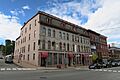
Adams-Pickering Block
-
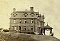
Bangor Children's Home
-
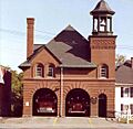
Bangor Hose House No. 5
-
Old Hampden Academy Building
-
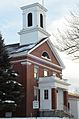
Hampden Congregational Church


