National Register of Historic Places listings in southeast Denver facts for kids
The National Register of Historic Places is a special list kept by the United States government. It includes buildings, places, and even neighborhoods that are important because of their history, architecture, or what they mean to American culture. When a place is on this list, it means it's recognized as a valuable part of our country's past.
This article explores some of the amazing historic places found in Southeast Denver, Colorado. This part of Denver is generally east of the South Platte River and south of Sixth Avenue. Denver has over 300 places on the National Register, and 45 of them are right here in Southeast Denver!
Contents
Historic Places in Southeast Denver
Southeast Denver is home to many interesting places that have been recognized for their historical importance. Let's explore a few of them!
Parks and Green Spaces
Denver is known for its beautiful parks, and some of them are so special they're on the National Register.
Alamo Placita Park
Located in the Speer neighborhood, Alamo Placita Park was added to the National Register in 1986. This park is a lovely green space that has been enjoyed by the community for many years. It's a great example of early 20th-century park design in Denver.
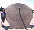
Cranmer Park
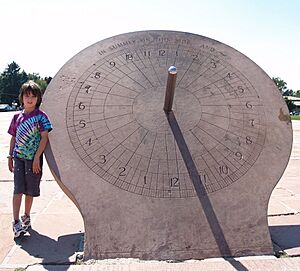
Cranmer Park, located in the Hilltop neighborhood, became a historic site in 1986. This park is famous for its large sundial and amazing views of the Rocky Mountains. It's a popular spot for families and offers a peaceful escape in the city.
Washington Park
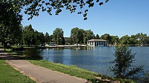
Washington Park is a very large and well-loved park and neighborhood in Denver. It was added to the National Register in 1986. The park itself is a beautiful example of landscape design, with lakes, gardens, and wide-open spaces. The surrounding neighborhood is also part of the historic district, showing how people lived and built homes around this central green area.
Important Buildings and Homes
Many historic buildings and houses in Southeast Denver tell stories of the past.
Chamberlin Observatory
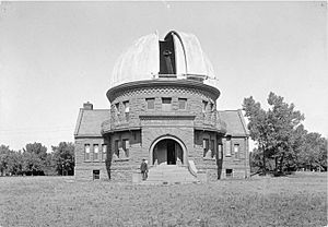
The Chamberlin Observatory is a fascinating building located in University Park. Listed in 1980, this observatory is part of the University of Denver and has been used for studying the stars and planets for over a century. It's a great place to learn about astronomy and see historic telescopes.
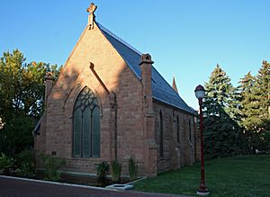
Chapel No. 1
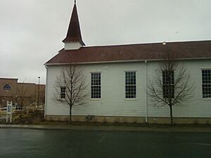
Found on the former Lowry Air Force Base (now the Lowry Field neighborhood), Chapel No. 1 was added to the National Register in 1982. This chapel served the military community at Lowry Air Force Base for many years and is an important reminder of the base's history.
Four-Mile House
The Four-Mile House is one of the oldest buildings in Denver, listed way back in 1969! Located in the Washington Virginia Vale neighborhood, this house was a popular stop for travelers and pioneers heading west. It's a living history museum today, showing what life was like in early Colorado.
Evans Memorial Chapel
Also on the University of Denver campus, the Evans Memorial Chapel was listed in 1974. This beautiful chapel is known for its unique architecture and peaceful setting. It has been a significant part of the university's history and community.
Cranmer House
The Cranmer House, located in the Hilltop neighborhood, was added to the National Register in 2005. This house is a great example of the grand homes built in Denver during the early 20th century. It shows the architectural styles popular at the time.
First Avenue Hotel
The First Avenue Hotel, located at 101 North Broadway, was added to the National Register in 2020. This building has a long history and represents an important part of Denver's past, likely serving as a place for travelers and residents for many years.
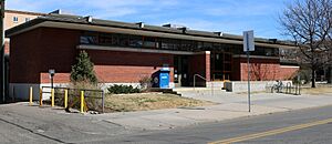
Ross-Broadway Branch, Denver Public Library
The Ross-Broadway Branch of the Denver Public Library is a community landmark in the Baker neighborhood. It was listed in 2016. Libraries are important centers for learning and community, and this building has served its neighborhood for a long time.
Historic Districts and Parkways
Some historic listings cover larger areas, like entire neighborhoods or special streets.
Country Club Historic District
The Country Club Historic District in the Country Club neighborhood was listed in 1979. This area is known for its beautiful, well-preserved homes and tree-lined streets. It gives us a look into how wealthy Denver residents lived in the early 1900s.
Speer Boulevard
Speer Boulevard is a major road in Denver that was designed as a "parkway," meaning it combines a road with park-like features. It was added to the National Register in 1986. This boulevard is important because of its design and how it connects different parts of the city. It even extends into other parts of Denver!
South Side-Baker Historic District
The South Side-Baker Historic District in the Baker neighborhood was listed in 1985. This district includes many homes and buildings that show the history and development of this part of Denver. It's a great place to see different architectural styles from the past.
Places No Longer Listed
Sometimes, a historic place might be removed from the National Register. This usually happens if the building is changed too much or is torn down.
Broadway Bridge
The Broadway Bridge was once on the National Register, listed in 1985. However, it was removed in 1995 because it was demolished in 1988. This shows that even important structures can sometimes be lost.
David H. Moffatt House
The David H. Moffatt House was listed in 1971 but was removed in 1972 because it was demolished. David H. Moffatt was an important figure in Colorado's history, and his house was a significant landmark until it was taken down.
| Adams - Alamosa - Arapahoe - Archuleta - Baca - Bent - Boulder - Broomfield - Chaffee - Cheyenne - Clear Creek - Conejos - Costilla - Crowley - Custer - Delta - Denver - Dolores - Douglas - Eagle - El Paso - Elbert - Fremont - Garfield - Gilpin - Grand - Gunnison - Hinsdale - Huerfano - Jackson - Jefferson - Kiowa - Kit Carson - La Plata - Lake - Larimer - Las Animas - Lincoln - Logan - Mesa - Mineral - Moffat - Montezuma - Montrose - Morgan - Otero - Ouray - Park - Phillips - Pitkin - Prowers - Pueblo - Rio Blanco - Rio Grande - Routt - Saguache - San Juan - San Miguel - Sedgwick - Summit - Teller - Washington - Weld - Yuma |
Images for kids


