
Pembrey facts for kids
Quick facts for kids Pembrey
|
|
|---|---|
 Pembrey village post office |
|

Pembrey
|
|
| Population | 2,154 (2011) |
| OS grid reference | SN4201 |
| Community |
|
| Principal area | |
| Ceremonial county | |
| Country | Wales |
| Sovereign state | United Kingdom |
| Post town | LLANELLI |
| Postcode district | SA16 |
| Dialling code | 01554 |
| Police | Dyfed-Powys |
| Fire | Mid and West Wales |
| Ambulance | Welsh |
| EU Parliament | Wales |
| UK Parliament |
|
| Welsh Assembly |
|
Pembrey (in Welsh: Pen-bre) is a village in Carmarthenshire, Wales. It's located between Burry Port and Kidwelly, looking out over Carmarthen Bay. In 2011, about 2,154 people lived there. The wider area, called an electoral ward, had a population of 4,301. Pembrey is part of the community of Pembrey and Burry Port Town.
Contents
A Look at Pembrey's Past
The name Pembrey comes from the Welsh name Pen-bre. "Pen" means "head" or "top" in Welsh. "Bre" is an old Celtic word for a promontory, which is a piece of land that sticks out into the sea.
Ancient Times and Early Settlements
About 6,000 years ago, the coastline near Pembrey Mountain started to move back. This revealed land that shows people have lived here since the Iron Age. There are hill forts from around 400 BC. The Romans knew the people living here as the Demetae. Roman pottery has been found in the oldest parts of the village.
Later, Pembrey was part of a Welsh kingdom called Deheubarth. People think there might have been an early Norman motte-and-bailey castle near the village square. Some buildings from later Norman times still stand in the village today.
Norman Influence and St. Illtyd's Church
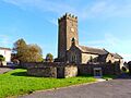
In the 12th century, a Norman squire named Arnold le Boteler lived in Pembrey. His home, Court Farm, Pembrey, was later made bigger into a Jacobean manor house and then a farm. It is now in ruins.
You can see the le Boteler (Butler) family symbol in the village church, St. Illtud. This church was built when le Boteler was alive. Its saint's name is linked to another of his properties near Llantwit Major. St Illtyd's is a very old and important building, listed as Grade II*.
Coal Mining and Pembrey's Harbours
Most of Pembrey village grew during the 18th and 19th centuries because of the coal mining boom. Pembrey was a busy port back then. Pembrey Mountain (in Welsh: Mynydd Penbre) was heavily mined by both Welsh and English companies for about 100 years. Some coal is still thought to be underground.
Pembrey's first harbour often got blocked with sand. So, a new harbour was built about a mile away, which was soon called Burry Port Harbour. The original harbour is now known as Pembrey Old Harbour.
Shipwrecks and Local Legends
Pembrey's mountain and beach, Cefn Sidan, have stories about villagers who were "wreckers." These people were supposedly known as Gwyr-y-Bwelli Bach (which means "People with Little Hatchets"). The legend says they would light fires to trick ships into thinking they were safe beacons, then raid the ships when they crashed. However, there's no strong proof that this actually happened.
Many ships were lost around Pembrey. One famous shipwreck was "La Jeune Emma" in 1828. This ship was sailing from the West Indies to France but was blown far off course. Thirteen of the 19 people on board drowned. This included Adeline Coquelin, who was the 12-year-old niece of Napoleon Bonaparte's divorced wife, Josephine de Beauharnais. Adeline is buried at St. Illtuds Church in Pembrey. The last large ship to be lost here was the "SS Paul," a four-masted sailing ship carrying timber, which ran aground in a storm in 1925.
Important Families in Pembrey
From the time of le Boteler until the early 1900s, Pembrey was often led by important families. The last of these was the Ashburnham family (Earl of Ashburnham). They lived at Pembrey House until the 1920s, but the house burned down about 50 years ago. Today, the Ashburnham Golf Club is a major sports spot. Ashburnham Road is one of the village's main streets, and the Ashburnham Hotel is a local place to stay.
Pembrey's Military History
Pembrey has strong military connections. Parts of the Ashburnham estate were once used as a firing range. In the 20th century, an RAF station, RAF Pembrey, was located here. It was important for Britain's defenses, housing both fighter and bomber planes.
Close by, a Royal Ordnance Factory, ROF Pembrey, made high explosives for Britain during wartime. Both these places were targets for Luftwaffe air raids over the village during World War II. A famous airman, Wing Commander Guy Gibson, who later led the Dambusters, was based in Pembrey. Flying ace Robert Stanford Tuck was also at Pembrey with 92 Squadron in 1940.
In the 1960s, there was a plan to build a testing range for weapons in Pembrey. But villagers fought against it with a "SOS" (Save Our Sands) campaign. Their efforts worked, and instead, Pembrey Country Park was created.
The Royal Air Force still uses a bombing range to the west of Pembrey Country Park near Kidwelly. The RAF Red Arrows aerobatics display team has performed over Kidwelly's carnival, with many of their amazing stunts happening right over Pembrey village.
Lifeboat Station History
Pembrey had an RNLI lifeboat station from 1863 to 1887. Before that, there was a station in Llanelli. The Pembrey station had to move to Burry Port because too much sand built up in the harbour.
Pembrey Today
Today, Pembrey doesn't have as many local jobs as it used to. Many people who live here travel to work in nearby Llanelli and Carmarthen. However, tourism has grown a lot, especially at the Country Park, along the Millennium Coastal Path, and in nearby Burry Port. There are places to stay like caravan parks, bed & breakfasts, and the Ashburnham Hotel.
In 2006, Court Farm was featured on a BBC2 TV show called Restoration Village. Experts agreed that the building needed a new roof and could become a cultural center. The farm didn't win the competition, but it's now looked after by a trust that is trying to raise money to restore it.
Pembrey Burrows and Cefn Sidan are now large areas for fun and recreation, managed by local councils. Some popular attractions include:
- The Millennium Coastal Path for walking and cycling.
- Ski Pembrey, an artificial ski center with a toboggan ride.
- St. Illtyd's Church and the village square.
- Mountain walks and picnic spots.
- The traditional links golf course.
- Pembrey Old Harbour.
- Pembrey Country Park.
- The Pembrey Circuit, which is the National Motorsport Centre of Wales.
- Horse-riding.
- A working airfield and flying club at Pembrey Airport.
The Carmarthenshire Land Sailing Club uses the beach for wind-powered activities like Land sailing, kite buggying, and Kite landboarding.
When you enter the country park, you can see some old bunkers. These are what's left of the Royal Ordnance Factory that closed in 1965. The woods and bunkers were even a focus for an episode of Living TV's Most Haunted in April 2008.
The name of the village has also been used for a place called Pembrey, Delaware, in the United States, which is a short drive from Philadelphia.
Notable People from Pembrey
- Edward Banks (1820–1910), a cricketer who played for Kent County Cricket Club.
- Sir John Ivan George Cadogan (1930–2020), a British organic chemist.
- Hugh Davies (1932–2017), a Welsh cricketer and radio commentator.
- Josh Sheehan (born 1995), a professional footballer who has played over 200 club games and 5 for the Wales team.
Getting Around Pembrey
The Pembrey and Burry Port railway station is actually in Burry Port. It's on the West Wales line, with trains going to Milford Haven and Manchester (via Cardiff), and twice a day to London. From 1909 to 1953, the Pembrey station on the Burry Port and Gwendraeth Valley Railway also served the village.
Buses connect Pembrey to Carmarthen and Swansea. The closest major highway is the M4. Pembrey Airport doesn't have regular flights, but it offers services for private and business planes, including executive jets. Pembrey Airfield is often used by the military, so you might need permission to land there. It can also handle passenger charter flights.
Images for kids
-
St Illtyd's church

See also
 In Spanish: Pembrey para niños
