Pembroke Pines, Florida facts for kids
Quick facts for kids
Pembroke Pines, Florida
|
|||
|---|---|---|---|

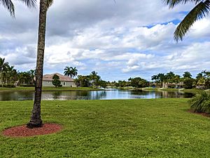
Pembroke Falls, a residential development in Pembroke Pines, Florida
|
|||
|
|||
| Motto(s):
"Join Us - Progress with Us"
|
|||
| Country | |||
| State | |||
| County | Broward | ||
| Unofficially incorporated (village) | March 2, 1959 | ||
| Incorporated (village) | January 16, 1960 | ||
| Incorporated (city) | May 22, 1961 | ||
| Government | |||
| • Type | Council-Manager | ||
| Area | |||
| • Total | 34.76 sq mi (90.03 km2) | ||
| • Land | 32.68 sq mi (84.64 km2) | ||
| • Water | 2.08 sq mi (5.39 km2) 4.88% | ||
| Elevation | 7 ft (2 m) | ||
| Population
(2020)
|
|||
| • Total | 171,178 | ||
| • Estimate
(2022)
|
169,876 | ||
| • Density | 5,237.84/sq mi (2,022.33/km2) | ||
| Time zone | UTC−5 (Eastern (EST)) | ||
| • Summer (DST) | UTC−4 (EDT) | ||
| ZIP codes |
33023-33029, 33330-33332
|
||
| Area code(s) | 954, 754 | ||
| FIPS code | 12-55775 | ||
| GNIS feature ID | 0288686 | ||
| Website | City of Pembroke Pines | ||
Pembroke Pines is a city in southern Broward County, Florida, United States. It is about 22 miles (35 km) north of Miami. Pembroke Pines is a large suburb and the fourth-most populated city in the Miami metropolitan area. In 2020, its population was 171,178 people.
Contents
History of Pembroke Pines
Pembroke Pines officially became a city on January 16, 1960. Its name comes from Sir Edward J. Reed. He was a member of Britain's Parliament. In 1882, he started a company to buy a lot of swampland in Florida. A road built through this land was called Pembroke Road. When the city was being formed, the first mayor, Walter Smith Kipnis, suggested "Pembroke Pines." He chose this name because of the pine trees growing near Pembroke Road.
Early Settlers and Growth
The first people in this area were Native Americans. They arrived about 4,000 years ago. Bones of animal hunters from 10,000 years ago were found nearby. This shows that people might have lived here even earlier.
The community began as agricultural land with many dairy farms. After World War II, more people moved here. Many service members retired and settled in the area. The first homes were built in 1956. The area was first called the "Village of Pembroke Pines." It became a village in 1959.
Becoming a City and Expanding
In January 1960, Pembroke Pines held another election. The village officially became a city. This first city area was small, less than one square mile. It was located between Hollywood Boulevard and SW 72nd Avenue. The Florida Turnpike was to the east.
Over time, the city grew bigger. In 1977, a maximum security prison was built in the northwest part of town. It closed in 2012. In 1980, the city doubled in size. Land from Flamingo Road to U.S. 27 was added. This included C.B. Smith Park and the former Hollywood Sportatorium. Also in 1980, Interstate 75 was extended through the city. By 1984, it reached Pines Boulevard.
Population Boom and Schools
Pembroke Pines grew very quickly in the 1990s. This was partly because of Hurricane Andrew in 1992. Thousands of people from southern Miami-Dade County moved north to Broward County. Many chose Pembroke Pines. In 1999, Pembroke Pines was the third "Fastest Growing City" in the United States.
This growth meant more schools were needed. In 2003, Charles W. Flanagan High School had almost 6,000 students. It was the most populated high school in Florida. To help with this, the city started its own charter school system. By 2006, Pembroke Pines had the largest charter school system in the county. The city also has campuses for Broward College and Florida International University.
City Challenges and Hurricanes
In 2001, a study said that the intersection of Pines Boulevard and Flamingo Road was the most dangerous in the U.S. The city worked to redesign and expand it.
Hurricanes have also affected Pembroke Pines. In 1999, Hurricane Irene brought a lot of rain. In 2004, Hurricane Frances and Jeanne caused minor damage. The 2005 hurricane season was tough. Hurricane Katrina passed directly over the city as a Category 1 storm. It caused downed power lines and trees. Later, the eye of Hurricane Wilma passed nearby. The city experienced very strong winds. Most of the city lost power for days. Schools were closed for two weeks.
Geography and Climate
Pembroke Pines is located at 26°0′45″N 80°18′49″W / 26.01250°N 80.31361°W.
A 2017 study showed that Pembroke Pines is one of the U.S. cities most at risk from coastal flooding. About 116,000 residents live in areas that could flood.
Climate in Pembroke Pines
Pembroke Pines has a tropical monsoon climate. This means it has hot, wet summers and warm, dry winters.
| Climate data for North Perry Airport, Florida, 1991–2020 normals, extremes 1999–present | |||||||||||||
|---|---|---|---|---|---|---|---|---|---|---|---|---|---|
| Month | Jan | Feb | Mar | Apr | May | Jun | Jul | Aug | Sep | Oct | Nov | Dec | Year |
| Record high °F (°C) | 85 (29) |
91 (33) |
94 (34) |
98 (37) |
97 (36) |
99 (37) |
98 (37) |
98 (37) |
98 (37) |
94 (34) |
101 (38) |
91 (33) |
101 (38) |
| Mean maximum °F (°C) | 85.4 (29.7) |
87.2 (30.7) |
89.9 (32.2) |
92.1 (33.4) |
93.4 (34.1) |
95.7 (35.4) |
95.1 (35.1) |
95.6 (35.3) |
94.2 (34.6) |
91.8 (33.2) |
87.8 (31.0) |
86.0 (30.0) |
97.0 (36.1) |
| Mean daily maximum °F (°C) | 76.9 (24.9) |
78.9 (26.1) |
81.3 (27.4) |
84.5 (29.2) |
87.3 (30.7) |
90.0 (32.2) |
91.7 (33.2) |
91.8 (33.2) |
89.8 (32.1) |
86.8 (30.4) |
82.2 (27.9) |
78.6 (25.9) |
85.0 (29.4) |
| Daily mean °F (°C) | 68.1 (20.1) |
70.2 (21.2) |
72.7 (22.6) |
76.4 (24.7) |
80.0 (26.7) |
83.0 (28.3) |
84.4 (29.1) |
84.6 (29.2) |
83.2 (28.4) |
80.1 (26.7) |
74.7 (23.7) |
70.7 (21.5) |
77.3 (25.2) |
| Mean daily minimum °F (°C) | 59.4 (15.2) |
61.5 (16.4) |
64.1 (17.8) |
68.3 (20.2) |
72.7 (22.6) |
75.9 (24.4) |
77.1 (25.1) |
77.5 (25.3) |
76.5 (24.7) |
73.4 (23.0) |
67.1 (19.5) |
62.9 (17.2) |
69.7 (20.9) |
| Mean minimum °F (°C) | 42.3 (5.7) |
46.0 (7.8) |
49.6 (9.8) |
58.0 (14.4) |
64.4 (18.0) |
71.4 (21.9) |
72.3 (22.4) |
73.3 (22.9) |
72.3 (22.4) |
62.1 (16.7) |
53.2 (11.8) |
49.1 (9.5) |
39.9 (4.4) |
| Record low °F (°C) | 34 (1) |
35 (2) |
40 (4) |
51 (11) |
56 (13) |
67 (19) |
69 (21) |
69 (21) |
67 (19) |
46 (8) |
43 (6) |
34 (1) |
34 (1) |
| Average precipitation inches (mm) | 2.71 (69) |
2.83 (72) |
2.68 (68) |
3.18 (81) |
5.18 (132) |
8.72 (221) |
6.82 (173) |
8.49 (216) |
7.98 (203) |
7.65 (194) |
3.56 (90) |
2.18 (55) |
61.98 (1,574) |
| Average precipitation days (≥ 0.01 in) | 8.5 | 7.7 | 7.2 | 7.4 | 11.6 | 17.8 | 17.4 | 18.6 | 17.9 | 14.2 | 10.0 | 9.7 | 148.0 |
| Source: NOAA (mean maxima/minima 2006–2020) | |||||||||||||
Neighboring Areas
Pembroke Pines is surrounded by several other cities and natural areas:
- Southwest Ranches, Davie, Cooper City, Hollywood are to the north.
- The Everglades is to the west.
- Hollywood is to the east.
- Miramar is to the south.
The area of Pembroke Pines west of Interstate 75 is called "West Pines." Most of the neighborhoods there were built after Hurricane Andrew.
Population and People
| Historical population | |||
|---|---|---|---|
| Census | Pop. | %± | |
| 1960 | 1,429 | — | |
| 1970 | 15,496 | 984.4% | |
| 1980 | 35,776 | 130.9% | |
| 1990 | 65,452 | 82.9% | |
| 2000 | 137,427 | 110.0% | |
| 2010 | 154,750 | 12.6% | |
| 2020 | 171,178 | 10.6% | |
| U.S. Decennial Census | |||
Pembroke Pines has grown a lot over the years. In 1960, there were only 1,429 people. By 2020, the population had grown to 171,178.
The city is very diverse. In 2020, about half of the people were Hispanic or Latino. Many other groups also live in Pembroke Pines, including White (non-Hispanic), Black or African American, and Asian residents.
Education in Pembroke Pines
Broward County Public Schools serve the students in Pembroke Pines. The city also has many charter schools. The City of Pembroke Pines even runs its own charter school system.
Public High Schools
- Charles W. Flanagan High School
- West Broward High School
Some parts of the city also attend Everglades High School and Miramar High School in Miramar, and McArthur High School in Hollywood.
Public Middle Schools
- Pines Middle School
- Silver Trail Middle School
- Walter C. Young Middle School
Some parts of the city also attend Apollo Middle School and Driftwood Middle School in Hollywood, and Glades Middle School and New Renaissance Middle School in Miramar.
Public Elementary Schools
- Chapel Trail Elementary School
- Lakeside Elementary School
- Palm Cove Elementary School
- Panther Run Elementary School
- Pasadena Lakes Elementary School
- Pembroke Lakes Elementary School
- Pembroke Pines Elementary School
- Pines Lakes Elementary School
- Silver Palms Elementary School
Some parts of the city also attend Boulevard Heights Elementary School and Sheridan Park Elementary School in Hollywood, Hawkes Bluff Elementary School in Davie, Manatee Bay Elementary School in Weston, and Miramar Elementary School, Silver Lakes Elementary School, Silver Shores Elementary School, Sunset Lakes Elementary School, and Sunshine Elementary School in Miramar.
Charter Schools
- Pembroke Pines Charter High School
- Somerset Academy Charter High School
- Pembroke Pines Charter Middle School (Central, West, and Academic Village)
- Franklin Academy Charter School [K–8]
- Renaissance Charter Schools at Pines [K–8]
- Somerset Academy Charter Middle School
- Atlantic Montessori Charter School
- Greentree Preparatory Charter School
- Pembroke Pines Charter Elementary School (East, Central, West, and Florida State University campus)
- Renaissance Charter Schools at Pines [K–8]
- Somerset Academy Charter Elementary School
Colleges and Universities
- Florida Career College Pembroke Pines Campus
- The Broward-Pines Center regional campus of Barry University
- The Broward-Pines Center regional campus of Broward College
- The Broward-Pines Center regional campus of Florida International University
- The South regional campus of Broward College
- Keiser University Pembroke Pines Campus
Transportation and Roads
Airports
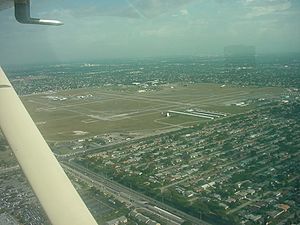
For bigger flights, people in Pembroke Pines use Fort Lauderdale–Hollywood International Airport and Miami International Airport. The city also has its own airport, North Perry Airport. This airport is for smaller, general aviation planes.
Public Transportation
Broward County Transit provides local bus service. The city also works with Broward County Transit to offer more bus routes within Pembroke Pines.
Major Highways

 Interstate 75
 Florida's Turnpike (SR 91)
Other Important Roads
Street Names
Streets in Pembroke Pines are numbered like those in Hollywood, its neighbor. To tell them apart, "west" is added to the direction. Streets north of Pines Boulevard are "northwest," and those south are "southwest."
Notable People from Pembroke Pines
Many well-known people have lived in Pembroke Pines, including:
- Eric Alejandro, Olympic hurdler
- Jim Alers, fighter
- Noah Allen, soccer player for Inter Miami CF
- Kenny Anderson, former NBA player
- Baby Ariel, social media star, singer, and actress
- Geno Atkins, NFL defensive lineman
- Kodak Black, rapper
- Ethan Bortnick, pianist, singer, actor
- Bridget Carey, technology journalist
- Triston Casas, baseball player for the Boston Red Sox
- Conceited, rapper
- Danny Farquhar, MLB player
- Jeff Fiorentino, MLB player
- Shayne Gostisbehere, NHL defenseman
- David Hess, MLB pitcher
- Maurice Kemp, basketball player
- Sofia Kenin, tennis player, 2020 Australian Open winner
- Mike Napoli, MLB player
- Joe Perez, MLB player
- Chase Priskie, NHL player
- Lil Pump, rapper
- Omar Raja, founder of House of Highlights
- Manny Ramírez, retired MLB player
- Juan Sebastián Restrepo, Army medic
- Fernando Rodney, MLB pitcher
- Lawrence Taylor, former NFL star
- Niki Taylor, model
- Vince Taylor, professional bodybuilder
- Bella Thorne, actress and model
- Touki Toussaint, MLB player
- Mark Vientos, MLB player
- David Villar, MLB player
- Mike White, NFL quarterback
- Walter C. Young, Florida legislator
- Colin Castleton, NBA Player
See also
 In Spanish: Pembroke Pines (Florida) para niños
 | William Lucy |
 | Charles Hayes |
 | Cleveland Robinson |


