Perkins County, South Dakota facts for kids
Quick facts for kids
Perkins County
|
|
|---|---|

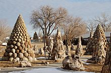
Petrified Wood Park in Lemmon, South Dakota
|
|

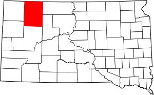
Location within the U.S. state of South Dakota
|
|
 South Dakota's location within the U.S. |
|
| Country | |
| State | |
| Founded | November 3, 1908 (established) 1909 (organized) |
| Named for | Henry E. Perkins |
| Seat | Bison |
| Largest city | Lemmon |
| Area | |
| • Total | 2,891 sq mi (7,490 km2) |
| • Land | 2,870 sq mi (7,400 km2) |
| • Water | 20 sq mi (50 km2) 0.7% |
| Population
(2020)
|
|
| • Total | 2,835 |
| • Estimate
(2023)
|
2,834 |
| • Density | 0.9806/sq mi (0.37862/km2) |
| Time zone | UTC−7 (Mountain) |
| • Summer (DST) | UTC−6 (MDT) |
| Congressional district | At-large |
Perkins County is a county located in the state of South Dakota, USA. In 2020, about 2,835 people lived here. The main town, or county seat, is Bison.
Perkins County was created in 1908 and officially started in 1909. It was named after Henry E. Perkins, an important person from Sturgis, South Dakota.
Contents
Geography of Perkins County
Perkins County is located in the northern part of South Dakota. Its northern border touches the state of North Dakota. Two important rivers, the Grand River and the Moreau River, flow eastward through the county. Shadehill Reservoir is a large lake on the Grand River.
The county's land has rolling hills and is mostly dry. It has some farms and slopes gently towards the east. The highest point is about 3,097 feet (944 meters) above sea level. Perkins County covers a total area of 2,890 square miles (7,485 km²). Most of this is land, with only a small part being water. It is the second-largest county in South Dakota by area.
The "McFarthest Spot"
In 2009, Perkins County became famous for a fun fact. Someone calculated that a spot in the county was the farthest place from any McDonald's restaurant in the continental United States. It was about 107 miles (172 km) away by air. Later, in 2010, this "McFarthest Spot" was updated to be in the middle of the Nevada Desert.
Main Roads in Perkins County
These are the major highways that pass through Perkins County:
Neighboring Counties
Perkins County shares borders with these other counties:
- Adams County, North Dakota - north
- Corson County - east
- Ziebach County - southeast
- Meade County - south
- Butte County - southwest
- Harding County - west
Protected Natural Areas
Perkins County has several protected natural areas where people can enjoy the outdoors:
- Grand River National Grassland (part)
- Hugh Glass State Lakeside Use Area
- Lemmon Lake State Game Production Area
- Llewellyn Johns State Recreation Area
- Owens Lake State Game Production Area
- Shadehill State Game Production Area
- Shadehill State Recreation Area
- Sorum Dam State Game Production Area
- Vobejda Dam State Game Production Area
Lakes and Reservoirs
Here are some of the lakes and reservoirs in Perkins County:
- Flat Creek Lake
- Lemmon Lake
- Owens Lake
- Shadehill Reservoir
- Sorum Dam
- Vobejda Dam
People of Perkins County (Demographics)
| Historical population | |||
|---|---|---|---|
| Census | Pop. | %± | |
| 1910 | 11,348 | — | |
| 1920 | 7,993 | −29.6% | |
| 1930 | 8,717 | 9.1% | |
| 1940 | 6,585 | −24.5% | |
| 1950 | 6,776 | 2.9% | |
| 1960 | 5,977 | −11.8% | |
| 1970 | 4,769 | −20.2% | |
| 1980 | 4,700 | −1.4% | |
| 1990 | 3,932 | −16.3% | |
| 2000 | 3,363 | −14.5% | |
| 2010 | 2,982 | −11.3% | |
| 2020 | 2,835 | −4.9% | |
| 2023 (est.) | 2,834 | −5.0% | |
| U.S. Decennial Census 1790-1960 1900-1990 1990-2000 2010-2020 |
|||
2020 Census Information
According to the 2020 census, 2,835 people lived in Perkins County. There were 1,257 households and 784 families. The population density was about 1 person per square mile.
2010 Census Information
In 2010, there were 2,982 people living in the county. Most residents (96.9%) were white. About 1.3% were Native American. Many people had German (47.4%) or Norwegian (26.2%) backgrounds. The average age of people in the county was 48.5 years old.
The average income for a household was $33,361. About 18.7% of the population lived below the poverty line.
Towns and Communities
Cities
Towns
- Bison (this is the county seat)
Census-Designated Places
Small Unincorporated Communities
These are small places that are not officially organized as cities or towns:
Ghost Towns
These are towns that used to exist but are now abandoned:
Townships
Townships are smaller local government areas within the county:
- Ada
- Anderson
- Antelope
- Barrett
- Beck-Highland
- Bison
- Brushy
- Burdick
- Cash
- Castle Butte
- Chance
- Chaudoin
- Clark
- De Witt
- Duell
- Englewood
- Flat Creek
- Foster
- Fredlund
- Glendo
- Grand River
- Hall
- Horse Creek
- Liberty
- Lincoln
- Lemmon
- Lodgepole
- Lone Tree
- Maltby
- Marshfield
- Martin
- Meadow
- Moreau
- Plateau
- Rainbow
- Rockford
- Scotch Cap
- Sidney
- Strool
- Trail
- Vail
- Vickers
- Viking
- Vrooman
- Wells
- White Butte
- White Hill
- Wilson
- Wyandotte
Unorganized Territories
These areas are not part of any township:
- Duck Creek
- East Perkins
- Independence
- Pleasant Valley
- South Perkins
- Southwest Perkins
- West Central Perkins
- West Perkins
Education
Students in Perkins County attend schools in these districts:
- Bison School District 52-1
- Faith School District 46-2
- Lemmon School District 52-4
See also
 In Spanish: Condado de Perkins (Dakota del Sur) para niños

