Peter I Island facts for kids
Quick facts for kids
Peter I Island
Peter I Øy (Norwegian)
|
||
|---|---|---|
|
Dependent territory of Norway
|
||
|
||

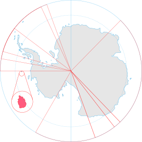
Location of Peter I Island (circled in red, relative to Antarctica)
|
||
| Sovereign state | Norway | |
| Annexed by Norway | 6 March 1931 | |
| Dependency status | 24 March 1933 | |
| Antarctic Treaty | 23 June 1961 | |
| Government | Dependency under a constitutional monarchy | |
|
• Monarch
|
Harald V | |
|
• Administered by
|
Ministry of Justice and Public Security | |
| Area | ||
|
• Total
|
154 km2 (59 sq mi) | |
| 95% | ||
| Highest elevation | 1,640 m (5,380 ft) | |
| Population | ||
|
• Estimate
|
0 | |
| ISO 3166 code | AQ | |
| Internet TLD | ||
Peter I Island (Norwegian: Peter I Øy) is an island made by a volcano in the Bellingshausen Sea. No one lives on this island. It is about 450 kilometers (280 miles) from Antarctica.
Norway claims Peter I Island as its own territory. It is one of three Norwegian areas in the Antarctic and Subantarctic regions. The island is about 11 by 19 kilometers (7 by 12 miles) long. Its total area is 156 square kilometers (60 square miles). This makes it a bit bigger than Staten Island in New York, USA.
The highest point on the island is Lars Christensen Peak. It stands 1,640 meters (5,380 feet) tall. Almost all of Peter I Island is covered by a thick layer of glacier ice. Most of the year, it is surrounded by pack ice. This makes it very hard to reach. There are not many animals living on the island. You can mostly find some seabirds and seals there.
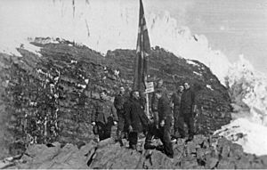
The island was first seen by Fabian Gottlieb von Bellingshausen on January 21, 1821. He named it after Peter I of Russia. But no one actually landed on the island until February 2, 1929. This first landing was made by Nils Larsen and Ola Olstad. Their trip was part of the Second Norvegia Expedition. A man named Lars Christensen paid for their journey.
They claimed the island for Norway. Norway officially took control of it in 1931. It became a special territory, or "dependency," in 1933. The next time anyone landed on the island was in 1948. Since then, scientists have done some research there. A few tourists have also visited. In 1961, the island became part of the Antarctic Treaty System. This treaty helps protect Antarctica. Since 1987, there has been an automatic weather station on the island. Also, some amateur radio groups have visited the island.
Contents
Discovering Peter I Island
The first time Peter I Island was seen was on October 21, 1821. This happened during an expedition led by Fabian Gottlieb von Bellingshausen. He was sailing with his ships, the Vostok and Mirny, under the Russian flag. He named the island after Tsar Peter I the Great of Russia.
However, thick pack ice stopped Bellingshausen from getting closer than 25 kilometers (16 miles) to the island. Peter I Island was the first land ever seen south of the Antarctic Circle. This also made it the southernmost land known at that time. In January 1910, a French expedition led by Jean-Baptiste Charcot confirmed Bellingshausen's discovery. But they also could not land. Pack ice stopped them about 5 kilometers (3 miles) from the island.
In 1926 and 1927, a Norwegian man named Eyvind Tofte sailed around the island. He also studied it from his ship, the Odd I. But he could not land either.
A Norwegian whale-ship owner named Lars Christensen paid for several trips to the Antarctic. He did this partly for science and partly to claim land for Norway. He wanted Norway to have its own land for whaling stations. This way, taxes from whaling would go to Norway.
The first expedition to successfully land on the island was the second Norvegia expedition. Lars Christensen paid for this trip. It was led by Nils Larsen and Ola Olstad. They landed on February 2, 1929. They claimed the island for Norway. Larsen tried to land again in 1931, but the pack ice stopped him.
On March 6, 1931, the King of Norway officially announced that the island belonged to Norway. Then, on March 23, 1933, the island was declared a "dependency." This means it is a territory controlled by Norway.
Later Visits and Research
The next time someone landed on Peter I Island was on February 10, 1948. This was again by Nils Larsen, on his ship Brategg. Scientists spent three days studying the island's plants, animals, rocks, and water. But then, the pack ice forced them to leave. The expedition built a small hut. Inside, they left a copy of the document from 1929 that claimed the island for Norway.
On June 23, 1961, Peter I Island became part of the Antarctic Treaty. Norway had signed this treaty in 1959. The treaty makes sure that scientists from any country can visit the island freely. It also says the island can only be used for peaceful activities.
Since then, different countries have landed on the island for scientific research. A small number of ships have also brought tourists to the island.
In 1987, the Norwegian Polar Institute sent five scientists to the island. They stayed for eleven days. Their main goals were to take photos from the air and measure the land. This helped them create an accurate map of the island. They also studied marine life, rocks, and other things. The team built an automatic weather station on the island.
Three times, groups of amateur radio operators have visited the island. These trips were in 1987, 1994, and 2006.
Geography and Landscape
Peter I Island is a volcanic island. This means it was formed by a volcano. It is about 450 kilometers (280 miles) from the coast of Ellsworth Land in Antarctica. It is also about 1,400 kilometers (870 miles) southwest of Smith Island. The island covers an area of 154 square kilometers (59 square miles). Almost all of it, about 95%, is covered by a thick glacier of ice.
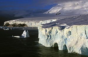
Around the island, there is an ice wall about 40 meters (130 feet) tall. This wall is made of the edge of the glacier. There are also steep cliffs. Some areas have bare rock sticking out from the ice.
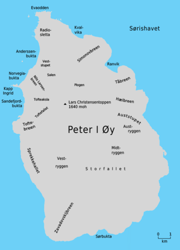
It is very hard to land on the island. There are only three places where ships can land. This is only possible during the short time of year when the island is not surrounded by thick pack ice. These landing spots are on the west side, at Kapp Ingrid Christensen. This cape is a piece of land that sticks out into the sea. It separates two bays called Norvegiabukta and Sandefjordbukta.
On the cape, there are some narrow strips of beach that are good for landing. The beach in Norvegiabukta is only 4 meters (13 feet) wide. You can reach it through a natural arch called Tsarporten. The west side of the island has a flat area. The north and south coasts have ice shelves, which are floating sheets of ice. The eastern side is the steepest. It has two tall rock columns with flat tops in the sea.
The island is a shield volcano. This type of volcano is wide and flat, like a warrior's shield. Scientists are not sure if it is still active. They think it erupted between 100,000 and 350,000 years ago. The top of the volcano, Lars Christensen Peak, has a round crater about 100 meters (330 feet) wide. This peak is 1,640 meters (5,380 feet) high. It is named after Lars Christensen, who funded many expeditions. It's not known if the volcano is completely dead. The top of the volcano looks like it hasn't been changed by glaciers. This might mean it erupted just a few centuries ago.
Environment and Wildlife
The only plants on Peter I Island are mosses and lichens. These plants are very tough and can live in the extremely cold Antarctic climate. The island has very strong winds and freezing temperatures. It snows a lot, which keeps most plants from growing.
The island is a place where a few types of seabirds come to lay their eggs. These include southern fulmars, Wilson's storm petrels, and Antarctic terns. Penguins, like Adélie and chinstrap penguins, sometimes visit the island.
There are many seals around the island. You can often see crabeater seals and leopard seals. There are also smaller numbers of southern elephant seals.
How Peter I Island is Governed
Peter I Island is one of two areas in Antarctica that Norway claims. The other is Queen Maud Land. Peter I Island is special because it is the only claim that is not a pie-shaped "sector" of Antarctica.
Because the island is south of 60°S latitude, it is covered by the Antarctic Treaty. This treaty allows scientists from any country to visit the island freely. It also says that the island can only be used for peaceful activities. Norway, Australia, France, New Zealand, and the United Kingdom all agree to recognize each other's claims in Antarctica.
The Norwegian government manages the island through the Polar Affairs Department. This department is part of the Ministry of Justice and Public Security in Oslo. The rules for Norway owning the island are in the Dependency Act of March 24, 1933. This law says that Norwegian laws about crime, private matters, and court rules apply to the island. Other laws also apply if they specifically say so. The law also states that all land on the island belongs to the government. It also forbids storing or exploding nuclear materials there.
Since May 5, 1995, Norwegian law has required all Norwegian activities in Antarctica to follow international environmental rules for the region. So, any Norwegian citizen planning to do something on Peter I Island must tell the Norwegian Polar Institute. The institute can stop any activity that does not follow the rules. Everyone visiting the island must follow laws about protecting nature, handling waste, preventing pollution, and having insurance for search and rescue operations.
See also
 In Spanish: Isla Pedro I para niños
 | Victor J. Glover |
 | Yvonne Cagle |
 | Jeanette Epps |
 | Bernard A. Harris Jr. |


