
Pinet, Spain facts for kids
Quick facts for kids
Pinet
|
|||
|---|---|---|---|
 |
|||
|
|||

Pinet
Location in Spain
|
|||
| Country | |||
| Autonomous community | |||
| Province | Valencia | ||
| Comarca | Vall d'Albaida | ||
| Judicial district | Ontinyent | ||
| Area | |||
| • Total | 11.9 km2 (4.6 sq mi) | ||
| Elevation | 359 m (1,178 ft) | ||
| Population
(2018)
|
|||
| • Total | 156 | ||
| • Density | 13.11/km2 (33.95/sq mi) | ||
| Demonym(s) | Pinetell, pinetella | ||
| Time zone | UTC+1 (CET) | ||
| • Summer (DST) | UTC+2 (CEST) | ||
| Postal code |
46838
|
||
| Official language(s) | Valencian and Spanish | ||


Pinet is a small town located in the Valencian Community, Spain. It is in the north-east part of the Vall d'Albaida region, which is in the south of the province of Valencia. Pinet is about 82.6 kilometers (51 miles) away from Valencia, the main city of the region.
Pinet shares its borders with several other towns. These include Barx, Quatretonda, Gandia, and Llutxent. All these towns are also located within the province of Valencia.
Contents
What's in a Name?
The name of Pinet comes from the Valencian word pi. This word means "pine tree". So, Pinet is like "Pine Town".
A Look Back at Pinet's History
Pinet has a long history. It used to be part of the Llutxent area, controlled by powerful families. These families included the Maza family, and later the Mandas and Dos Aguas families.
In 1530, a special church area called the Vicariate of Pinet was created. It was managed by the Dominicans, a group of religious people, from Llutxent until 1835.
How Pinet's Population Changed
After a historical event called the expulsion of the Moriscos in 1609, Pinet's population became very small. By 1646, only 20 people lived there. This event greatly affected many areas in Valencia.
Towards the end of the 1700s, the number of people grew to about 150. By the early 1900s, it reached around 300. In 1920, Pinet had 434 residents. After this, the population slowly decreased. This was common in many rural parts of Spain as people moved to bigger cities.
Here's how the population has changed more recently:
| Recent Population Changes | |||||||||
| 1990 | 1992 | 1994 | 1996 | 1998 | 2000 | 2002 | 2004 | 2005 | 2007 |
| 268 | 249 | 252 | 235 | 228 | 212 | 207 | 192 | 185 | 190 |
Pinet's Economy

For a long time, Pinet's economy was based on farming. Farmers grew crops like grapes, prunes, olives, almonds, and carob without much extra water. They also grew apples and other fruits using irrigation.
People also made things by hand. They built dry stone walls and created baskets, rugs, espadrilles (shoes), and hats. These items were made from plants like esparto grass and palm leaves.
Since the mid-1900s, these traditional jobs have become less common. Now, Pinet's economy also includes raising animals like chickens and pigs. Services, construction, and tourism are also important parts of the local economy.
Geography and Landscape
Pinet is located in the north-east of the Vall d'Albaida region. It covers an area of 11.9 square kilometers (about 4.6 square miles).
The town sits at the top of a valley shaped like a horseshoe. The ground in the valley is made of reddish clay. This clay was carried there by water flowing down from the mountains. These mountains are found at the north and north-east edges of the valley.
The height of the land in Pinet varies a lot. The lowest point is 466 metres above sea level. The highest point is 700 meters (about 2,300 feet) high. This high area is called Alto del Collado dels Caragols. The village of Pinet itself is located at a height of 348 meters (about 1,142 feet).
The Pinet River
The River Pinet flows through the town from north to south. It eventually joins the River Vernisa, which then flows into the River Serpis.
Like many rivers in this area, the River Pinet is a wash. This means it is dry during the summer months. However, it fills with a lot of water after heavy rains. These rains are common in autumn and spring and are known as a "cold drop" weather event.
Pinet's Climate
Pinet has a typical Mediterranean climate. This means it has hot summers and winters that are fairly cold. On average, it snows about twice a year. The climate is classified as Csa in the Köppen climate classification system.
The average temperature throughout the year is about 17 °C (63 °F). In summer, temperatures can reach up to 45 °C (113 °F). In winter, they can drop to -7 °C (19 °F).
Pinet usually gets about 600 mm (23.6 inches) of rain each year. However, in some recent years, it has rained more than 1000 mm (39.4 inches). This is mainly due to the very heavy downpours that happen in autumn. These are caused by the "cold drop" weather phenomenon.
Plants and Animals of Pinet

In the lower parts of the valley, you'll find plants related to dryland fruit farming. These include almond trees, olive trees, and apricot trees. The mountains around Pinet have pine and cork forests. You can also see shrubland with holly oak trees and wild herbs. Some of these herbs are silene diclinis, laurel, snapdragon, honeysuckle, rosemary, thyme, and oregano.
The forests are home to many birds, such as Bonelli's eagle, golden eagle, and short-toed snake eagle. You might also see common bent-wing bats, finches, and greenfinches. The fruit trees attract birds like titmice, sparrows, blackbirds, golden orioles, wrens, nightingales, Cetti's warblers, and wagtails.
You can also find larger animals like wild boar and rabbits in the area.
El Surar: A Special Forest

El Surar is a very special place. It is a Municipal Natural Park and is home to the southernmost cork oak forest in the Valencia region.
The government of Valencia, called the Generalitat Valenciana, made El Surar a Municipal Natural Park on March 4, 2005. You can visit El Surar by walking, cycling, riding a horse, or driving. There are signs from Pinet village that show you the way.
The Route of the Monasteries

Pinet is part of the Route of the Monasteries of Valencia. This is a special long-distance walking route (GR-236). It is a religious and cultural path that connects five old monasteries. These monasteries are all located in the central part of the Province of Valencia.
There are four different ways to travel this route. Three of them pass through Pinet: by foot, on horseback, and by mountain bike. There's even a special path that goes through El Surar.
Important Buildings and Celebrations
St. Peter the Apostle Church
Pinet has a beautiful church called the Parish Church of St. Peter the Apostle. It was built in the 1700s. It has one main area for people to sit, with small chapels built between strong stone supports.
Town Festivities
Pinet celebrates its main festivals during the last weekend of June. These celebrations honor St. Peter and the Christ of the Mountain.
Pinet "Llata" Festival
This is a fair held in late summer. It celebrates Pinet's old tradition of making things from esparto grass and palm leaves. At the festival, you can watch people show how they make these crafts. There are also workshops where you can try it yourself. Plus, there's a food fair with delicious local dishes!
Getting Around Pinet
The only road in Pinet is the CV-608. This road connects Pinet village to Llutxent village. From Llutxent, you can get onto the CV-610 regional road. This larger road links the towns of Gandia and Xàtiva.
Gallery
-
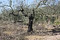
An olive tree in Pinet
-
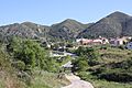
A view of Pinet
-
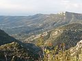
A view of Pinet from El Surar


See also
 In Spanish: Pinet para niños
