Rattling Run (Little Mahanoy Creek tributary) facts for kids
Quick facts for kids Rattling Run |
|
|---|---|

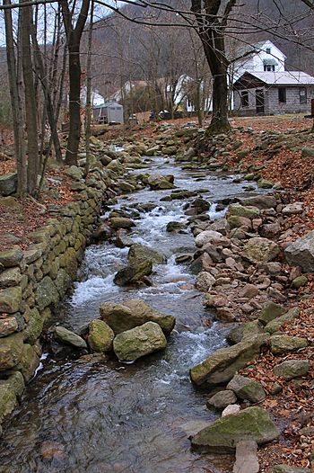
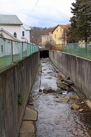
Rattling Run looking upstream in Gordon
|
|
| Physical characteristics | |
| Main source | 1,460 ft (450 m) |
| River mouth | Little Mahanoy Creek 810 ft (250 m) 40°45′10″N 76°20′22″W / 40.75286°N 76.33935°W |
| Length | 2.3 mi (3.7 km) |
| Basin features | |
| Progression | Little Mahanoy Creek → Mahanoy Creek → Susquehanna River → Chesapeake Bay |
| Basin size | 2.75 sq mi (7.1 km2) |
Rattling Run is a small stream, also called a tributary, that flows into Little Mahanoy Creek. It is located in Schuylkill County, Pennsylvania, in the United States. This stream is about 2.3 miles (3.7 km) long. It winds its way through Butler Township and Gordon.
The area of land that drains water into Rattling Run is about 2.75 square miles (7.1 km2). This stream is not considered polluted. It is also several miles away from a big coal mining area called the Western Middle Anthracite Field. The Gordon Reservoir, a water storage area, is found within the land that drains into Rattling Run. This stream is important for fish, especially coldwater fish, and also for fish that travel to different places.
Contents
Where Rattling Run Flows
Rattling Run starts high up on a mountain in Butler Township. It flows west-southwest for a short distance. Then, it turns northwest and flows through the Gordon Reservoir.
The stream then turns west-southwest again for a longer stretch. It enters a valley and flows next to Highridge Park Road/Gordon Mountain Road. After that, it turns northwest for a while. Finally, it turns north-northwest and enters the town of Gordon. Here, it leaves its valley. After a short distance, it meets and joins Little Mahanoy Creek.
Rattling Run joins Little Mahanoy Creek about 0.32 miles (0.51 km) before Little Mahanoy Creek reaches its own end.
Water Quality of Rattling Run
Rattling Run is considered a healthy stream. It is not listed as a polluted waterbody. The water at the end of Rattling Run usually has a slightly lower pH (meaning it's a bit more acidic) than Little Mahanoy Creek. It also has slightly lower amounts of nutrients.
Scientists measured the amount of water flowing in Rattling Run. In March 2001, about 9.61 cubic feet per second (0.272 m3/s) of water flowed. In August 2001, it was about 1.99 cubic feet per second (0.056 m3/s). The amount of dissolved oxygen in the water was 12.3 mg/l in March 2001 and 8.3 mg/l in August 2001.
The pH of the stream was 5.7 in March 2001 and 6.5 in August 2001. The water also had small amounts of dissolved substances like aluminum, manganese, and iron. For example, in March 2001, there was 0.14 mg/l of dissolved aluminum.
The stream also contains small amounts of nitrate and phosphorus. In March 2001, the nitrate level was 0.10 mg/l, and in August 2001, it was 0.18 mg/l. The dissolved sulfate concentration was 7 mg/l in March 2001 and 6 mg/l in August 2001.
Land and Rocks Around the Stream
The land around the end of Rattling Run is about 810 feet (250 m) above sea level. Where the stream begins, its source, the elevation is higher, about 1460 feet (450 m) above sea level.
Rattling Run is located a few miles south of the Western Middle Anthracite Field. This is an area known for coal. The stream has experienced some erosion, which means the water has worn away the sides and bottom of its channel.
Rattling Run's Watershed
The watershed of Rattling Run covers an area of about 2.75 square miles (7.1 km2). This is the entire area of land where all the rain and snowmelt eventually drain into Rattling Run. The end of the stream is in the Ashland area on maps from the United States Geological Survey. However, its beginning is in the Minersville area.
The reservoir called the Gordon Reservoir is located on Rattling Run. In 1970, the Butler Township Water Company owned this reservoir. The main purpose for Rattling Run is to support aquatic life, meaning plants and animals that live in the water.
Rattling Run experienced flooding in April 1972 during Hurricane Agnes. This caused damage to nearby buildings.
History of Rattling Run
Rattling Run was officially added to the Geographic Names Information System on August 2, 1979. This system keeps track of names and locations of places.
In the early 1900s, Rattling Run was stocked with 1000 adult and young rainbow trout. This means fish were added to the stream to help the fish population. Improvements were made to the stream in 1937. Ideas for Flood control to protect Gordon from Rattling Run floods were discussed in 1976.
A steel culvert bridge, which carries Gordon Mountain Road over Rattling Run, was built in 1959. This bridge is 24.0 feet (7.3 m) long. In June 1991, there were reports of pollution affecting Rattling Run and Little Mahanoy Creek.
Animals in Rattling Run
In 2001, scientists did not see any fish or macroinvertebrates (small creatures without backbones) in Rattling Run near Gordon. However, the stream is still classified as a Coldwater Fishery. This means it has the right conditions for fish that prefer cold water. It is also a Migratory Fishery, which means it is a place where fish travel through.


