Rockland, Massachusetts facts for kids
Quick facts for kids
Rockland, Massachusetts
|
||
|---|---|---|

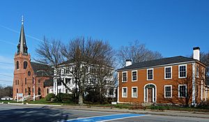
Union Street, Rockland
|
||
|
||

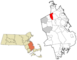
Location in Plymouth County in Massachusetts
|
||
| Country | United States | |
| State | Massachusetts | |
| County | Plymouth | |
| Settled | 1673 | |
| Incorporated | 1874 | |
| Government | ||
| • Type | Open town meeting | |
| Area | ||
| • Total | 10.1 sq mi (26.2 km2) | |
| • Land | 10.0 sq mi (26.0 km2) | |
| • Water | 0.1 sq mi (0.2 km2) | |
| Elevation | 140 ft (43 m) | |
| Population
(2020)
|
||
| • Total | 17,803 | |
| • Density | 1,780.3/sq mi (684.7/km2) | |
| Time zone | UTC−5 (Eastern) | |
| • Summer (DST) | UTC−4 (Eastern) | |
| ZIP Code |
02370
|
|
| Area code(s) | 339/781 | |
| FIPS code | 25-57775 | |
| GNIS feature ID | 0618351 | |
Rockland is a town located in Plymouth County, Massachusetts, in the United States. In 2020, about 17,803 people lived there. It's a friendly community with a rich history.
Contents
History of Rockland
Rockland was first part of a large land area given to Timothy Hatherly in 1654. This area was known as the Hatherly Grant. European settlers began living here in 1673. At that time, it was the northeastern part of the nearby town of Abington.
Becoming a Town
Rockland officially became its own town on March 9, 1874. It was named "Rockland" because of its many rocky areas. These rocky lands were better for building factories and businesses than for farming. During King Philip's War, the town was a temporary camp for King Philip's forces when they attacked Scituate.
Growth and Industry
Before the American Civil War, Rockland was important for producing lumber. This lumber was used to build ships in towns like Hanover and Scituate. During the 1800s and the Civil War, Rockland's businesses grew a lot. This was thanks to its shoe factories, lumber exports, and sawmills. However, production slowed down after the Great Depression.
After World War II, Rockland saw new business growth. Many suburban homes were built along Routes 123 and 139.
In the 1900s, part of the South Weymouth Naval Air Station was located in Rockland. This air station had landing strips that were used by the Navy. The airstrip closed in 1996 as part of a plan to close military bases.
Artist Community
In recent years, many artists have moved to Rockland. They like to use old factory buildings as places to work and meet. These buildings are mainly for businesses and storage, but artists use them a lot. Examples include the E.T. Wright Building and the Sandpaper Factory.
There was another artist community in the Codman Building, which used to be the Emerson Shoe Company. But in 2007, this building was changed to be for homes. This meant 30 to 40 artists had to leave. Now, it is a luxury apartment building called the Emerson Shoe Lofts. This building is the largest wooden structure in Rockland and is listed on the National Register of Historic Places.
Geography of Rockland
Rockland covers about 10.1 square miles (26.2 square kilometers). Most of this area, about 10.0 square miles (26.0 square kilometers), is land. Only a small part, about 0.1 square miles (0.2 square kilometers), is water. Rockland is the 307th largest community out of 351 in Massachusetts.
Neighboring Towns
Rockland shares borders with several towns:
- Weymouth to the northwest
- Hingham to the northeast
- Norwell to the northeast
- Hanover to the east
- Hanson to the south
- Whitman to the southwest
- Abington to the west
Rockland is about 8 miles (13 km) northeast of Brockton. It is also about 22 miles (35 km) south of Boston.
Natural Features
As its name suggests, Rockland has many rocky areas. There are also several ponds in town. These include Accord Pond, which is where Rockland meets Hingham and Norwell. Studleys Pond, also known as Reeds Pond, is located south of Rockland Center.
Several small streams, called brooks, flow through the town. One of these brooks starts at the Abington-Rockland Reservoir. Beech Hill is in the southern part of town, and Wyman Fields is to the north. Rockland also has several parks and a small town forest.
Transportation Routes
A small part of Massachusetts Route 3 (about 2/3 of a mile long) goes through the northeast corner of town. This highway provides access to Route 228. Route 123 and Route 139 run from west to east through the town. They share the same road for about 2/3 of a mile.
Rail and Air Travel
An old train line, part of the Old Colony rail line, used to run through Rockland. This line is now closed. However, the Old Colony Line still passes through nearby towns like Weymouth, Abington, and Whitman. This is part of the MBTA's commuter rail system. There are train stops in South Weymouth and Abington, close to Rockland.
Rockland does not have its own commercial airport. For national and international flights, people can use Logan International Airport in Boston. Another option is T. F. Green Airport in Rhode Island.
Rockland's Population
| Historical population | ||
|---|---|---|
| Year | Pop. | ±% |
| 1880 | 4,553 | — |
| 1890 | 5,213 | +14.5% |
| 1900 | 5,327 | +2.2% |
| 1910 | 6,928 | +30.1% |
| 1920 | 7,544 | +8.9% |
| 1930 | 7,524 | −0.3% |
| 1940 | 8,087 | +7.5% |
| 1950 | 8,960 | +10.8% |
| 1960 | 13,119 | +46.4% |
| 1970 | 15,674 | +19.5% |
| 1980 | 15,695 | +0.1% |
| 1990 | 16,123 | +2.7% |
| 2000 | 17,670 | +9.6% |
| 2010 | 17,489 | −1.0% |
| 2020 | 17,803 | +1.8% |
| 2022* | 17,609 | −1.1% |
| * = population estimate. Source: United States Census records and Population Estimates Program data. | ||
In 2000, there were 17,670 people living in Rockland. These people lived in 6,539 households, and 4,583 of these were families. The population density was about 1,763 people per square mile.
Diversity in Rockland
The town's population was mostly White (90.81%). There were also significant numbers of African American (5.71%) and Asian (1.08%) residents. About 1.02% of the population was Hispanic or Latino.
Household Information
More than 9,000 households were counted. In 34.2% of these homes, children under 18 lived there. About 52.7% of households were married couples. About 13.2% had a female head of household with no husband present. The average household had 2.67 people, and the average family had 3.23 people.
Age Groups
The population in Rockland was spread out by age:
- 26.5% were under 18 years old.
- 6.8% were between 18 and 24.
- 32.0% were between 25 and 44.
- 21.8% were between 45 and 64.
- 12.9% were 65 years or older.
The average age in town was 36 years.
Income and Poverty
The median income for a household in Rockland was $50,613. For a family, the median income was $60,088. The average income per person in the town was $23,068. About 6.1% of families and 6.8% of all people lived below the poverty line. This included 9.2% of those under 18 and 6.2% of those 65 or older.
Education in Rockland
Rockland has its own school system for about 2,500 students.
Elementary Schools
There are two elementary schools in Rockland:
- Phelps Elementary
- R. Stewart Esten Elementary
These schools teach students from kindergarten to fourth grade. The Phelps Elementary school is a new building, finished in 2022. It replaced the old Memorial Park and Jefferson elementary schools.
Middle and High Schools
The John W. Rogers Middle School is connected to the high school. It was completed in 2012. This school serves students from fifth through eighth grades. The Rockland Senior High School has been recently renovated. It teaches students from ninth through twelfth grade.
School Sports
Rockland High's sports teams are called the Bulldogs, or sometimes just 'Dogs. Their team colors are navy blue and white. They play in the South Shore League. Their main rival is Abington.
The Bulldogs have a strong basketball history. The boys' team won state championships in 2004. The girls' team won in 2000. The football team last won a Super Bowl in 2021. They beat Abington 23–13 at Gillette Stadium.
Other School Options
Besides the public high school, students can attend South Shore Vocational Technical High School in Hanover for free. Rockland also has a private Christian school called Calvary Chapel Academy. It teaches students from kindergarten through twelfth grade.
Children in Rockland can also attend South Shore Charter Public School. This school is in nearby Norwell. It accepts students from surrounding towns on the South Shore.
Many students also choose to go to private high schools in the area. These include:
- Cardinal Spellman High School in Brockton
- Notre Dame Academy in Hingham
- Archbishop Williams High School in Braintree
- Boston College High School in Boston
- Xaverian Brothers High School in Westwood
Rockland's Economy
Rockland is home to the main offices for several important companies:
- EMD Serono: This is the US headquarters for a biotechnology and pharmaceutical company.
- Rockland Trust Company: This is the largest publicly traded commercial bank based in Massachusetts. It has over 1,000 employees.
Revitalizing Rockland Center
Town leaders and citizens are working to make Rockland Center more lively. The area along Union Street has many buildings that combine businesses and homes. These buildings show the history of Rockland Center's busy past.
A detailed study was done by BSC Group and McCabe Enterprises. They gave ideas on how to redevelop the Center while keeping its historic look. New sidewalks and crossing areas were added in 2010. These were paid for with a federal grant.
The Iron Horse Preservation Society was hired to remove the old train tracks that ran through town. Now that the tracks are gone, the old line is used for walking and bike riding.
Media in Rockland
Newspapers
In 1884, a local newspaper called The Independent was started. Hulda Barker Loud was its first editor-in-chief. Today, Rockland shares a weekly newspaper with Abington called The Rockland Standard. Larger newspapers like The Patriot Ledger and The Brockton Enterprise cover the wider South Shore area.
Radio and Television
WRPS (88.3 FM) is a radio station owned by Rockland High School. Students and staff at the school run the station. The school also has two public access cable channels.
Places to Visit in Rockland
Historic Buildings
The Lower Union Street Historic District is a special area on Union Street. It runs from East Water Street to Market Street. Several buildings in Rockland are listed on the National Register of Historic Places because of their importance:
- Grand Army of the Republic Hall: Built in 1899.
- Mckinley School: Built in 1909 as the high school, now the Rockland Community Center.
- Phoenix Building: Built in 1929.
- Rockland Almshouse: Built in 1876, now home to an educational group.
- Rockland Memorial Library: Built in 1903.
- Rockland Trust Company building: Built in 1917.
- ET Wright Building: Built in 1880.
- Sandpaper Factory: Built in 1890.
- Holy Family Church: Built in 1883.
Notable People from Rockland
Many interesting people have come from Rockland:
- Brian Duffy (born 1953): An astronaut.
- George V. Higgins (1939–1999): An author.
- PJ Ladd (born 1983): A professional skateboarder.
- Hulda Barker Loud (1844–1911): A newspaper editor.
- Frederic O. MacCartney (1864–1903): A socialist politician.
- Maria Louise Pool (1841–1898): An author.
- Jonathan Togo (born 1977): An actor.
- Megan Khang (born 1997): A professional golfer.
See also
 In Spanish: Rockland (Massachusetts) para niños


