Roehampton facts for kids
Quick facts for kids Roehampton |
|
|---|---|
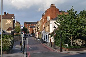
 Roehampton High Street |
|
| Population | 16,132 (2011 Ward of Roehampton and Putney Heath) |
| OS grid reference | TQ225745 |
| London borough | |
| Ceremonial county | Greater London |
| Region | |
| Country | England |
| Sovereign state | United Kingdom |
| Post town | LONDON |
| Postcode district | SW15 |
| Dialling code | 020 |
| Police | Metropolitan |
| Fire | London |
| Ambulance | London |
| EU Parliament | London |
| UK Parliament |
|
| London Assembly |
|
Roehampton is a part of London in the southwest. It is located in the London Borough of Wandsworth. Roehampton has many large council house areas. It is also home to the University of Roehampton.
Contents
What's in a Name?
The name Roehampton likely comes from the many rooks (a type of bird) that live in the area. You can still see many of these birds there today.
Where is Roehampton Located?
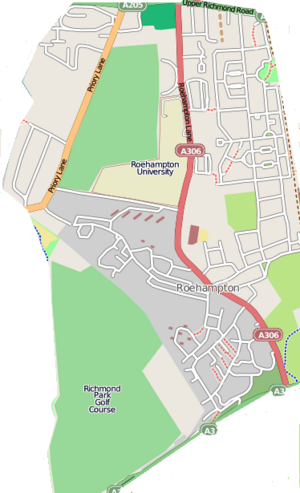
Roehampton is about 6.3 miles (10 km) southwest of Charing Cross, a famous spot in central London. It sits on high ground. To the north is Barnes. To the east are Putney and Putney Heath. Richmond Park and its golf course are to the west. South of Roehampton is Roehampton Vale, which is near the A3 road. Beyond that are Wimbledon Common and Putney Vale.
A Look Back at Roehampton's Past
Roehampton started as a small village. In the time of King Henry VII, it had only 14 houses. Most of the area was forest and open land. More people moved here in the 1700s and 1800s. It became a popular place for summer homes and large houses. This happened after Putney Bridge opened in 1729. Some of these old houses are still standing.
Historic Houses and Buildings
Roehampton House was built between 1710 and 1712. A famous architect named Thomas Archer designed it. Later, Sir Edwin Lutyens made it bigger in 1910. For many years, it was used by Queen Mary's Hospital. Now, it has been turned into private apartments.
Parkstead House was built in 1760. It was once home to Lady Caroline Lamb, a well-known socialite. In 1861, a religious group called the Jesuits bought it. They used it as a training center and called it Manresa House. The poet Gerard Manley Hopkins lived there. Today, Parkstead House belongs to Roehampton University.
Other old houses owned by the university include Mount Clare (built in 1772) and Grove House (built in 1777). It is believed that the famous landscape designer Capability Brown planned the gardens at Grove House. Downshire House, built in 1770, is another historic building in the area.
Templeton House is a large Georgian house from the 1780s. It was used as a hospital during both World Wars. From 1919 to 1920, Winston Churchill lived there. He later became a famous Prime Minister. In 2010, the house was sold and became a family home again. Some scenes for the TV show Downton Abbey were filmed at Templeton House.
Roehampton became its own church area in 1845. This was after Holy Trinity Church was built in 1842. The Society of Jesus also started St Joseph Church in 1869.
The Maharajah Duleep Singh lived for a time in Ashburton House in Roehampton. He was visited there by the Prince Consort and the Prince of Wales.
During World War I, there was a training school for "Kite Balloons" here. These were large balloons used for looking over battlefields. This land is now part of the university and a golf course.
Much of the old village of Roehampton still has large, detached houses. You can also see an old watering trough. This was used for carriage-horses in Victorian times. It is at the corner of Medfield Street and Roehampton Lane.
Council Housing Estates
The London County Council (LCC) built many council houses in Roehampton. These are homes built by the local government for people who need affordable housing. The Dover House Estate was built in the 1920s and 1930s. The Alton Estate was built in the 1950s. These estates took up many large gardens and woodlands.
The Dover House Estate was designed to be like a "Garden City." It has pretty houses inspired by the Arts and Crafts style. The idea was to create homes that felt friendly and unique. They were built around shared green spaces. There were also areas for growing vegetables, and two of these still exist.
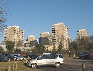
The Alton Estate is one of the biggest council housing areas in the UK. It has a mix of modern buildings, both low and high-rise. Alton East (built in 1958) has a gentle, Scandinavian-inspired style. Alton West (built in 1959) has a more bold, "brutalist" look. Some of the tall buildings in Alton West were inspired by the famous architect Le Corbusier. When it was finished, Alton West was seen as a great example of council housing after World War II.
Today, the Alton Estate is part of a plan to improve the area. Programs like SureStart help families and children.
Roehampton Today
Roehampton has several "conservation areas." These are special places where old buildings and the environment are protected. This includes parts of the Alton and Dover House estates. It also includes the center of Roehampton Village. You can find old pubs like the King's Head Inn and the Montague Arms, which are from the 1600s.
In 2007, a new path was created from the Alton Estate into Richmond Park. This path, for walking and cycling, opened in 2014.
Roehampton is known for its many schools and colleges. The University of Roehampton has about 10,500 students. Queen Mary's Hospital is a teaching hospital. Kingston University and South Thames College also have campuses here. Roehampton has long been a major place for training teachers.
Other important places in Roehampton include The Priory Clinic, a private hospital. There is also the Bank of England Sports Centre, Rosslyn Park Rugby Football Club, and the Roehampton Club. The International Tennis Federation (ITF) moved to Roehampton in 1998. The Lawn Tennis Association also built its new headquarters here in 2007.
Who Lives in Roehampton?
In the 2011 census, no single ethnic group was the majority in Roehampton and Putney Heath. The largest group was White British (45%). Other large groups included other White (18.4%), Black African (7.9%), and other Asian (4.6%).
Most people (59.1%) living in Roehampton and Putney Heath in 2011 were born in England. Other common birthplaces included Poland (5.6%), Pakistan (1.8%), and the Philippines (1.6%).
Regarding religion, 52.9% of people were Christian. About 23.6% said they had no religion. 11.1% were Muslim, and smaller numbers followed other religions like Hinduism and Buddhistism.
Getting Around Roehampton
Roehampton has several bus routes. Bus 170 goes to Victoria, 265 to Putney and Tolworth, 419 to Richmond, 493 to Richmond and Tooting, 430 to South Kensington, and 85 to Putney and Kingston.
The closest train stations are Barnes and Putney. The University of Roehampton has asked for Barnes station to be renamed "Barnes & Roehampton." This is because the station is located between both areas.
Roehampton in Books and Movies
Roehampton appears in the novel The Sleeper Awakes by H. G. Wells. In the story, Roehampton is one of several "Flying Stages" (basic airports). A big battle in the book happens at the Flying Stage in Roehampton.
The Alton Estate has been used for filming movies and TV shows. The movie Fahrenheit 451 (1966) used parts of the estate. It helped create the look of a bleak future society. The film Sweeney 2 (1978) also filmed its opening scenes in the Danebury Avenue area of the estate.
Famous People from Roehampton
- James Beck (1929–1973), actor
- Sam Bird, racing driver
- Emily Blunt, actress
- Simon Le Bon, lead singer of Duran Duran
- Earl of Cork and Orrery, author
- Gwendolen Fitzalan-Howard, Duchess of Norfolk
- William Harvey, physician (discovered how blood circulates)
- Jack Hawkins, actor
- Gerard Manley Hopkins, poet
- Roy Kinnear, actor
- Dawid Malan, cricketer
- William Pitt the Younger, prime minister
- Brian Rix, actor
- Ryan Sessegnon, footballer
- Sir Joseph Simpson, Chief Commissioner of the Metropolitan Police
- Peter Westbury, racing driver
Places Near Roehampton
 |
Mortlake, East Sheen | Barnes | Putney |  |
| Richmond Park, East Sheen | Putney, Putney Heath | |||
| Richmond Park, Kingston Vale | Putney Vale, Wimbledon Common | Putney Heath |
 | DeHart Hubbard |
 | Wilma Rudolph |
 | Jesse Owens |
 | Jackie Joyner-Kersee |
 | Major Taylor |


