Salt River (California) facts for kids
Quick facts for kids Salt River |
|
|---|---|

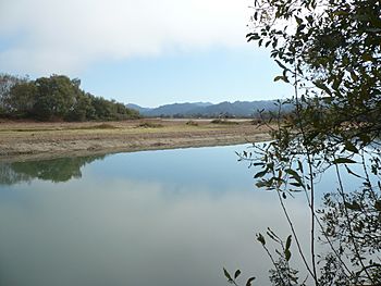
The Salt River restoration reopened the lower portion of the river to flow on October 9, 2013.
|
|

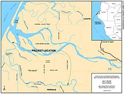
Map of the Salt River
|
|
| Country | United States |
| State | California |
| County | Humboldt |
| City | Ferndale |
| Physical characteristics | |
| Main source | Wildcat Mountains Humboldt County, California 3 ft (0.91 m) 40°32′32.08″N 124°16′58.21″W / 40.5422444°N 124.2828361°W |
| River mouth | Pacific Ocean Humboldt County, California 0 ft (0 m) 40°38′16.46″N 124°18′47.21″W / 40.6379056°N 124.3131139°W |
| Length | 7 mi (11 km) |
| Basin features | |
| River system | Eel River (California) |
| Basin size | 17.03 sq mi (44.1 km2) |
The Salt River is a small river in California. It used to be a busy waterway, flowing about 9 miles (14 km) from near Fortuna to the Pacific Ocean. Over time, siltation (when dirt and mud build up) from logging and farming made the river too shallow.
Historically, the Salt River was an important route for boats until the early 1900s. Today, it collects water from streams flowing from the Wildcat Hills. People started working to restore the river in 1987. Construction began in 2012, and water flowed in the restored channel in October 2013.
Contents
River Geology and Formation
The California Coast Ranges are young mountains that are still growing taller. This happens because of tectonic plates pushing them up. These fast-rising slopes often cause natural landslides. These landslides have filled the river channel with dirt and rocks for thousands of years.
Evidence from tree stumps near the river's mouth shows that the land dropped about 11 feet (3.4 m) during the huge 1700 Cascadia earthquake on January 26, 1700. The area around the Salt and Eel rivers sits on a basin called the Eel River syncline. This basin is affected by several faults, including the Russ and Ferndale faults. The larger San Andreas Fault system also impacts the land here.
Streams Flowing into Salt River
Five named streams flow from the Wildcat Hills into the Salt River. These streams bring water and also sediment (dirt and mud) into the river.
| Tributary Name | Watershed drainage | Distance of Tributary Mouth to Eel |
|---|---|---|
| Russ Creek | 2,080 acres (840 ha) | 0.8 miles (1.3 km) |
| Smith Creek | 160 acres (65 ha) | 2.1 miles (3.4 km) |
| Reas Creek | 1,210 acres (490 ha) | 3.2 miles (5.1 km) |
| Francis Creek | 1,990 acres (810 ha) | 4.9 miles (7.9 km) |
| Williams Creek | 3,660 acres (1,480 ha) | 7.4 miles (11.9 km) |
Source: United States Department of Agriculture.
River Animals and Plants
The Salt River estuary (where the river meets the ocean) is home to four types of anadromous fish. These fish, called salmonids, live in the ocean but travel to freshwater to lay their eggs. They include coho salmon, chinook salmon, rainbow trout, and coastal cutthroat trout.
About two dozen other fish species live in the estuary. These include herring, sardine, smelt, stickleback, perch, sculpin, sole, and flounder. There is also an invasive freshwater fish called the Sacramento pikeminnow.
Nature in the Past
Long ago, the Salt River delta was covered by Sitka spruce and Alder trees. These trees shaded ferns and bushes. Further upstream, coast redwoods grew tall. Early explorers described beautiful prairies surrounded by fir and redwood trees, filled with ferns, grasses, and wildflowers.
The land was known to flood often. The fern prairies were also hard to turn into farmland. Many animals lived here, such as California mule deer, Roosevelt elk, bears, ducks, geese, and other waterfowl. Salmon and other anadromous fish used the Salt River to reach smaller streams in the Wildcat Hills. They would lay their eggs there, and their young would grow before swimming back to the ocean.
Salt River History
Early History
The Wiyot people had a village called Wotwetwok near the Salt River. They called the river Oka't. For thousands of years, families from this village hunted, fished, and used the river for travel.
The first European to explore the Eel River area was Sebastián Vizcaíno in January 1603. He was sailing for the King of Spain, looking for a secret passage to the north. Instead, he found the native people, whom he described as "uncultured."
Shipping and Trade
The first American ship to enter the Salt River was the Jacob M. Ryerson on April 3, 1850. It sailed up the river the next day. In 1851, the river was wide and deep enough for boats to travel far upstream. By the mid-1870s, large steamships sailed about 2.5 miles (4.0 km) up the Salt River to Port Kenyon. The river channel there was about 200 feet (61 m) wide and 13 feet (4.0 m) deep at low tide.
However, the river quickly started to fill with silt (mud and sand) and flood every year. This caused businesses and people to move from Port Kenyon to nearby towns like Ferndale.
Many ships faced problems on the Salt River. In 1877, the steamer Continental was wrecked. Other ships like the George Harley and Alexander Duncan took over. The Alexander Duncan also wrecked in 1878. The Thomas A. Whitelaw, built for the Eel River trade, carried cargo and passengers. Later, the Ferndale and the paddle-wheel steamer Edith also sailed the route.
Shifting sandbars at the mouth of the Eel River made shipping difficult. In 1884, both the Ferndale and the Edith were lost, stopping the Port Kenyon to San Francisco route. The steamer Mary D. Hume was then used, but it often had to wait weeks to cross the river bar. This led to calls for dredging (clearing out) the river mouth. Even with a tugboat, the river continued to get shallower.
By 1890, the mouth of the Salt River was shoaling (getting shallower). In 1893, the steamer Weeott began service, carrying many goods like butter, eggs, lumber, and salmon. Sadly, the Weeott wrecked in 1899, causing two deaths. In 1902, the Argo took over, but shipping on the Salt River mostly ended by 1908. The building of Fernbridge in 1911 and the Eel River Railroad in 1914 made river shipping less necessary.
People realized that human activities were causing the river to fill with silt. As early as 1866, a pioneer settler named Uri Williams noted that the river was shallower. He blamed the clearing of land, farming, and livestock, which caused dirt to wash into the rivers.
Commercial Fishing
Commercial fish canning started in 1877. Canneries used the Salt River to ship out thousands of pounds of salmon every day. However, by 1892, the cannery closed because there were not enough fish.
A fish hatchery on Price Creek opened in 1897. It hatched 4 million salmon eggs and was the second largest hatchery in California. It operated until 1916. In 1906, a new cannery opened and brought in workers from different countries. Local residents were concerned, and the workers were moved to Indian Island for safety.
Land Reclamation Efforts
The Salt River Reclamation District was created in 1884. Its goal was to turn the marshy areas into farmland. Four years later, a surveyor from the U.S. Coast and Geodetic Survey noted that the dikes (walls) and blocked sloughs (small channels) were causing the Salt River delta to fill with sediment.
In 1897, a lawsuit was filed because reclamation work had caused the delta to fill up. This made it harder for ships to use Port Kenyon. A judge ruled in favor of the ranchers, stating that the closed channels were never meant for navigation. The case eventually went to the California Supreme Court in 1901.
Salt River Bridges
During the 1880s, people crossed the Salt River using a log pontoon bridge (a floating bridge). This bridge was near where the current Dillon Road bridge is today. When floods happened, one end of the bridge would be untied, and it would float freely. After the flood, it would be tied back up. This bridge needed constant repairs.
In 1886, the first permanent bridge was built, but it was destroyed in 1890. A new one was built in 1893, but it was also destroyed in the 1894 flood. The third bridge, built in 1894, had extra height. It was a Howe pony truss timber bridge. This bridge survived both a flood and the 1906 San Francisco earthquake, even when Port Kenyon sank several feet.
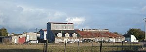
The Valley Flower Creamery was built in 1914 north of the Salt River. It grew over the years and operated for 45 years. In its early days, the creamery made about 75,000 pounds (34,000 kg) of butter and 37,000 pounds (17,000 kg) of casein every month. During World War I, they had a contract to supply the U.S. Navy with 150,000 pounds (68,000 kg) of butter.
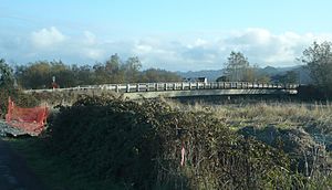
Because all their products had to cross the Salt River on the old timber bridge, the county replaced it in 1919. The new bridge was a 142 feet (43 m) reinforced concrete girder bridge. When it was built, it was the longest bridge of its type in the world. This bridge was eligible to be listed on the National Register of Historic Places in 1987. However, it was torn down and replaced by a concrete beam bridge in 1994.
River Siltation
Over time, the Salt River slowly filled with dirt and mud. This happened because of human activities like building dikes and levees for farming. Also, landslides and erosion from the hills brought more sediment into the river. Most of the original trees and plants were gone by 1900, which increased the amount of silt.
In just ten years, from 1889 to 1899, the river's depth changed from 20 feet (6.1 m) to only 2 feet (0.61 m). Logging in the Wildcat hills continued after World War II. This led to more logging roads and exposed slopes, causing even more siltation. By 1949, the Salt River was so shallow that a person could wade across parts of it at low tide.
After a huge flood in 1964, nearly 13,000 acres (5,300 ha) of land were covered by sand or silt. In 1967, residents built a levee to stop the Eel River from flowing into the Salt River during high water. This helped remove sediment. However, without the occasional overflow from the Eel River, and with new sediments from the 1992 Cape Mendocino earthquakes, the Salt River became mostly dry land by 2008.
In the 1970s, the California Department of Fish and Game stopped farmers from clearing local channels. Willows and brush quickly grew in the riverbed. This trapped more sediment, stopping almost all water flow in the lower half of the Salt River. This led to flooding and water quality problems.
The Eel River itself also carries less water now. This is due to the construction of the Pillsbury Dam and the Potter Valley Project. These projects divert 95 percent of the summer water flow to Sonoma County.
Restoring the River
After the river became almost completely filled with silt and caused annual winter flooding, the Eel River Conservation District was formed in 1987. Their goal was to reopen the Salt River. They worked with the United States Department of Agriculture but were denied funding in 1989.
The Eel River Conservation District became the Humboldt County Resource Conservation District in 1993. The California Conservation Corps cleared plants from the Salt River channel in 1996. The next year, the Federal Endangered Species Act listed coho salmon as endangered. Chinook salmon were listed as threatened in 1999, and steelhead trout in 2000. This made restoring the Salt River's habitat a top priority.
Francis Creek, a tributary, was rebuilt in 2002. The U.S. Army Corps of Engineers began studying the Salt River for ecosystem restoration. In 2004, a group of interested parties was formed, but all U.S. Army Corps funding was cut. Over the next two years, these groups raised over $6 million to start the Salt River Ecosystem Restoration Project. The Salt River Watershed Council was formed in 2007 to help manage the project long-term.
The Salt River restoration project received its final permit in September 2012. The plan was to restore the river's water flow by digging out the channel. It also included restoring the 444 acres (180 ha) Riverside Ranch and reducing sediment upstream. Many government agencies were involved in this 26-year process.
Construction on the first part of the project began in May 2013. The river's estuary was connected to the newly dug channel on October 9, 2013, when a temporary dam was removed.
 | William Lucy |
 | Charles Hayes |
 | Cleveland Robinson |


