Sara Sara facts for kids
Quick facts for kids Sara Sara |
|
|---|---|

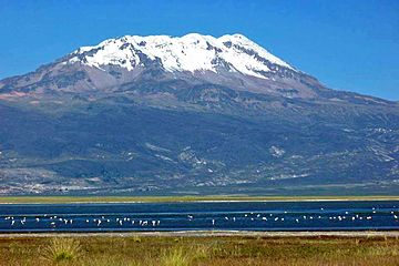
Sara Sara and Lake Parinacochas in front of it
|
|
| Highest point | |
| Elevation | 5,505 m (18,061 ft) |
| Prominence | 2,060 m (6,760 ft) |
| Listing | Ultra |
| Geography | |
| Parent range | Andes |
| Geology | |
| Age of rock | Pleistocene |
Sara Sara is a huge volcano in Peru, standing at 5,505 meters (about 18,061 feet) tall. It's located between Lake Parinacochas and the Ocoña River. This volcano was formed a long time ago during the Pleistocene era, which was the Ice Age. It grew in four main stages, creating a large, oval-shaped mountain made of lava flows and lava domes.
During the last big Ice Age, Sara Sara was covered in glaciers, and it might still have some ice today. The last time this volcano erupted was about 14,000 years ago. Scientists think it could erupt again in the future. Long ago, local people worshipped Sara Sara. Archaeologists even found the mummy of a 15-year-old Inca girl at its very top.
Contents
Where is Sara Sara Located?
Sara Sara is part of the Andes mountain range in Peru. You can find it in the Ayacucho Region, specifically in the Parinacochas Province and Paucar del Sara Sara Province. The town of Pausa is only about 12 kilometers (7.5 miles) away from the volcano. People in the nearby valleys grow crops for farming. There's also an old road that goes up the southern side of the volcano, reaching as high as 4,600 meters (15,092 feet).
What Does the Volcano Look Like?
The volcano is 5,505 meters (18,061 feet) high and has an oval shape. Its highest point is at the southern end of a long ridge that runs north to south. Sara Sara is a mix of lava domes and lava flows built on top of older volcanoes. It's about 1 kilometer (0.6 miles) taller than the land around it.
Lava flows and rocky debris from collapsing lava domes have spread out from the volcano. Some of these lava flows, called the "Mollebamba Volcanics," are very thick and can be as long as 15 kilometers (9 miles). There's also a newer cone made of ash and a recent lava flow on the eastern side. The western side of the volcano is very worn down by weather. To the west is Lake Parinacochas, and to the east is the Ocoña River.
Ice and Glaciers on Sara Sara
The volcano is surrounded by areas shaped by glaciers, like bowl-shaped hollows (cirques) and valleys. Scientists have found signs of two past ice ages here. The most recent one, called "Sara Sara II," saw glaciers reach down to about 4,500 meters (14,764 feet). The older one, "Sara Sara I," left behind networks of rocky ridges (moraines) at even lower heights.
Today, the permanent snowline on Sara Sara is around 5,200 meters (17,060 feet). Some say the mountain has a large ice cap, while others say it only has temporary snow. There are also "rock glaciers" – slow-moving mixtures of ice and rock – below the snowline. Water from the base of Sara Sara is used by local people for irrigation to water their crops.
How Sara Sara Formed
Sara Sara is part of a group of volcanoes in the Andes mountains called the Central Volcanic Zone. It's the northernmost volcano in this group. Many volcanoes in this area, like El Misti and Ubinas, have erupted in recent history. Sara Sara is currently a sleeping volcano.
These volcanoes form because the Nazca Plate (a large piece of Earth's crust) is slowly sliding under the South America Plate off the coast of Peru. This process creates magma, which then rises to form volcanoes.
Sara Sara is part of a 30-kilometer (18.6-mile) long chain of volcanoes that follows a crack in the Earth's crust. There's also a big geological line, called the Sara Sara lineament, that crosses the volcano.
The rocks that make up Sara Sara are mostly dacite, but also include andesite, rhyolite, and trachyandesite. These rocks contain different minerals like quartz and plagioclase, which tell scientists about the volcano's history.
Climate and Life Around the Volcano
The weather around Sara Sara changes a lot depending on how high you are. In the valleys, temperatures can be warm, but above 5,200 meters (17,060 feet), it's always freezing. Most of the rain falls in the summer, often as hail and snow at higher elevations, which can cover the ground for months. Above 4,500 meters (14,764 feet), it's always cold, never getting warmer than 5°C (41°F).
At lower heights, you can find trees. Higher up, only tough grasses like ichu and plants like quinoa grow. Farmers in the lower areas grow crops like alfalfa and maize (corn). People in the region also raise animals, run small businesses, and have some tourism.
When Did Sara Sara Erupt?
Sara Sara has been active for the past 2 million years. Scientists have divided its eruption history into four main stages:
- The first stage involved lava flows and domes. Two big events happened about 500,000 and 370,000 years ago. Part of the volcano also collapsed during this time.
- In the second stage, lava domes grew and sometimes collapsed. One such event on the eastern side was about 162,000 years ago.
- The third stage, starting around 63,000 to 58,000 years ago, built the main cone of the volcano with dacitic lava flows.
- The last stage, sometimes considered part of the third, produced long lava flows (up to 14 kilometers or 8.7 miles) from a cone called Yana Ranra on the eastern side. This happened about 14,000 years ago.
Sara Sara is currently a sleeping volcano, but there is some seismic activity (small earthquakes). In 1963, people reported seeing fumarolic activity, which are vents releasing steam and gases. There are also hot springs nearby, which suggests there might be a shallow magma chamber (a pool of molten rock) under the volcano.
Volcano Hazards and Watching Sara Sara
The Peruvian Geological Service considers Sara Sara to be "moderately dangerous." If it were to erupt, about 8,000 to 12,000 people living nearby could be in danger from lahars (mudflows), pyroclastic flows (fast-moving hot gas and ash), and falling ash. Towns like Pausa and Lake Parinacochas (which provides water for the region) are close to the volcano. Scientists have created maps to show the areas that would be most affected. Since 2018, the Peruvian Geological Service has been watching Sara Sara closely using tools to detect earthquakes and other changes.
Sara Sara's Ancient Importance

For a very long time, even before the Inca Empire, local people worshipped Sara Sara as a sacred mountain. The Incas even performed human sacrifices there. During the Inca times, Sara Sara was part of their Kuntisuyu province.
A priest named Cristóbal de Albornoz wrote in the 1570s that people considered Sara Sara a holy mountain. They would offer gold, silver, animals, and servants to it. In 1996, archaeologists made an amazing discovery: they found a burial site near the summit. Inside, they found the mummy of a 15-year-old girl, nicknamed "Sarita." She was found with offerings, like a llama and a silver object.
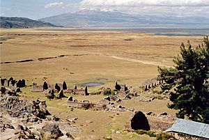
There are also stone walls on the ridge at the top of Sara Sara. These were first described in 1982 by archaeologist Johan Reinhard. In 1941, copper objects were found on the volcano's sides. The Yanapunku cave, located at 5,000 meters (16,404 feet), contains bones and ceramics from both the Inca and Wari cultures. Another site, Incaptiana, has Inca buildings on top of a hill at 4,565 meters (14,977 feet).
See also
 In Spanish: Sara Sara para niños
- Inka Wasi
- List of volcanoes in Peru
 | Jessica Watkins |
 | Robert Henry Lawrence Jr. |
 | Mae Jemison |
 | Sian Proctor |
 | Guion Bluford |


