Shelter Island, New York facts for kids
Quick facts for kids
Shelter Island, New York
|
||
|---|---|---|
| Town of Shelter Island | ||
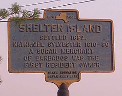
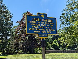
A historic marker plaque on Shelter Island explaining the history of the area.
|
||
|
||
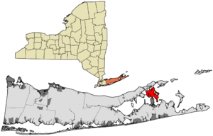
Location in Suffolk County
|
||
| Country | ||
| State | ||
| County | Suffolk | |
| Government | ||
| • Type | Civil Township | |
| Area | ||
| • Total | 29.11 sq mi (75.39 km2) | |
| • Land | 12.19 sq mi (31.58 km2) | |
| • Water | 16.92 sq mi (43.82 km2) | |
| Elevation | 56 ft (17 m) | |
| Population
(2010)
|
||
| • Total | 3,253 | |
| • Estimate
(2016)
|
2,413 | |
| • Density | 266.86/sq mi (103.01/km2) | |
| Time zone | UTC-5 (Eastern (EST)) | |
| • Summer (DST) | UTC-4 (EDT) | |
| ZIP Codes |
11964, 11965
|
|
| Area codes | 631, 934 | |
| FIPS code | 36-103-66839 | |
| GNIS feature ID | 0965037 | |
Shelter Island is an island town in eastern Suffolk County, New York. It is located near the eastern end of Long Island. About 3,253 people lived there in 2020.
Contents
History of Shelter Island
For a long time, Native American people lived on Shelter Island. These groups were related to those who lived north of Long Island Sound. When Europeans first arrived, the island was home to the Manhanset tribe. They spoke an Algonquian language. The Manhanset tribe called the island Manhansack-aha-quash-awamock. This name means "Island sheltered by islands."
Early European Settlers Arrive
Shelter Island was part of a large land grant given by King James I of England in 1620. Later, in 1636, King Charles I gave the island to William Alexander. He was the 1st Earl of Stirling. Alexander's agent, James Farret, was allowed to choose 12,000 acres (49 km2) for himself. Farret chose Shelter Island and Robin's Island. He then sold these islands to Stephen Goodyear. Goodyear was one of the people who started the New Haven Colony.
In 1651, Goodyear sold the island to a group of sugar merchants from Barbados. They paid 1,600 pounds of sugar for it. Nathaniel Sylvester (1610–1680) was one of these merchants. He became the island’s first European settler. Sylvester had lived and worked in Rotterdam, Netherlands, before moving to Barbados. His connections helped him build a large trading business.
On March 23, 1652, Sylvester made the purchase official. He signed an agreement with Youghco, the leader of the Manhanset tribe. The other owners, Sylvester’s brother Constant and Thomas Middleton, never came to Long Island. By 1673, Nathaniel Sylvester claimed ownership of Shelter Island and other nearby areas. The Manhansett tribe had become smaller and less powerful by then.
In 1652, Sylvester built a house on the island for his 17-year-old wife, Grissel Brinley. She was from London. The Sylvesters had eleven children who survived. A larger manor house, which you can still see today, was built in 1733 by one of Sylvester's grandsons.
The Sylvester estate became a big farm. They grew food and raised animals. They sent preserved meats and other supplies to Barbados. Workers included enslaved Native Americans, enslaved Africans, and English indentured servants. The Sylvesters were part of the "Triangle Trade." This trade connected the American colonies, Africa, and England. Sylvester's family continued to use enslaved people on the farm until the 1800s. About 200 Black people are buried at the Negro Burying Ground on the North Peninsula.
The Sylvesters also offered safety to many Quakers who were being treated unfairly. Sylvester Manor is still standing today, near New York State Route 114. It is still owned by Sylvester's family. Most of the original land has been sold to others.
After Nathaniel Sylvester died in 1680, Shelter Island was split between his two sons, Giles and Nathaniel II. In 1695, William Nicoll bought the area now called Mashomack Nature Preserve from Giles. Three years later, in 1698, George Havens bought 1,000 acres (4.0 km2) from Nathaniel II. This land is now the Center of the island. It stretched south to South Ferry and west to West Neck Creek. Over time, these large properties were divided. By the early 1700s, 20 families lived on Shelter Island. The Town of Shelter Island was officially created in 1730.
Shelter Island During the Colonial Era
James Nicoll Havens built a home on the island in 1743. He was a member of the New York Provincial Congress. He was also the first town supervisor on the island. His old home is now owned by the local historical society.
Jonathan Nicoll Havens (1757–1799) was born on Shelter Island. He was part of the First Continental Congress in 1774. He also helped New York approve the federal constitution in 1788. Mashomack Forest, now Mashomack Nature Preserve, was owned by the Nicolls family for 230 years. Nicolls Creek is named after them. A few Manhanset people still lived in the Sachem’s Neck area until the 1790s.
Shelter Island saw some military action during the early colonial times:
- The British took hay from Hay Beach during the American Revolution.
- The ship Paragon was built on the island at Lord’s Shipyard. In 1804, this ship successfully avoided a British blockade during the Napoleonic Wars.
- During the War of 1812, the British attacked many homes on the island.
The first ferry service to the island was run by the Boisseau family. The North Ferry started service to Greenport in 1868. Throughout the 1800s, the island was a base for fishermen. Fish processing plants sent their products all over the country.
Shelter Island Heights is Created
Shelter Island Heights was built in 1871 as a summer resort. A group of businessmen from Brooklyn bought land for this purpose. It was developed by the Shelter Island Grove and Camp Meeting Association of the Methodist Episcopal Church. For eight years, religious camp meetings were held on the island. Then they moved to Jamesport. During this time, Robert Morris Copeland designed the Union Chapel. It was built in 1875. In 1984, it was added to the National Register of Historic Places.
Shelter Island Heights was a carefully planned community. The houses were built in classic American styles. These included Stick-Eastlake, Queen Anne Style, and Colonial Revival. About 70 summer cottages were built in the Heights between 1872 and 1880. By 1890, the area had a clear architectural style. The houses have not changed much since then. Shelter Island Heights became a historic district in 1993.
At the start of the 1900s, fish processing plants were still active on the island. Some summer residents traveled there by steam ferries from New York City. White Hill is located above the North Ferry landing. The Prospect Hotel was built there. It burned down twice, once in 1942. Today, the land is a town park.
Shelter Island's Growth After 1900
Francis Marion Smith (1846–1931) was known as the "Borax King" because of his success in mining. Smith and his family bought a home on the island in 1892. He made it much larger, with over 30 rooms. He called his estate Presdeleau, which means "by the water" in French. By 1906, he owned over 500 acres (2.0 km2) on the south side of the island. Smith Cove and Smith Street are named after him. Smith brought deer from California to hunt in his "deer park." Their descendants still live on parts of the island.
Another rich person from the 1800s who had an estate on Shelter Island was Artemas Ward (1848–1925). He was a leader in mass-market advertising. Ward made a lot of money by controlling all advertising on New York City elevated trains and subways. He had a large estate on the south side of the island. Ward wrote a book about his great-grandfather, Major General Artemas Ward. He was a commander in the American Revolutionary War. Parts of Ward’s original estate have been fixed up.
After World War I, the island slowly started to develop more. Summer camps began in the 1920s. This included Camp Quinipet, a United Methodist Church camp. Houses were built in areas like Montclair Colony, Silver Beach, Ram Island, and Hilo Farms.
After the Great Depression, some summer cottages were left empty. It took a while for the island to recover. After World War II, more summer residents started coming back. In the 1950s, a farm cooperative grew lima beans on the island. This was the last time commercial farming happened on Shelter Island.
In the 1960s and 1970s, more families moved to Shelter Island to live there all year. The Gerard family owned land that had belonged to the Nicoll family for over 200 years. This land was later owned by financier Otto Kahn. Developers wanted to buy the 2,000 acres (8.1 km2). In 1980, The Nature Conservancy bought the land to protect it as a nature park forever. Half of the money to buy the forest was raised on the island. This created Mashomack Preserve.
Many Shelter Island residents today have family roots that go back to the time of the American Revolution. Some summer visitors are the fifth generation of their family to visit the island.
Geography and Natural Features
Shelter Island is located between the North and South Forks of Long Island. It is surrounded by Shelter Island Sound on three sides and Gardiners Bay on the fourth. You can reach the island by ferry from Greenport to the north. This trip takes about eight minutes. You can also take a ferry from North Haven to the south, which takes about five minutes. These two ferry crossings are connected by New York State Route 114, which goes across the island.
Shelter Island is about 8,000 acres (32 km2) in size. A large part of the island is protected wetlands and marshland. Nearly one-third of the island is owned by The Nature Conservancy. This land is kept wild as a nature preserve. The Preserve has four nature and bird-watching trails. They range from 1.5 miles (2.4 km) to 11 miles (18 km) long. There is also a special Braille trail for people who are visually impaired.
According to the United States Census Bureau, Shelter Island has a total area of 28.7 square miles (74 km2). Of this, 12.2 square miles (32 km2) is land, and 16.5 square miles (43 km2) (57.49%) is water.
Population and Demographics
| Historical population | |||
|---|---|---|---|
| Census | Pop. | %± | |
| 1790 | 201 | — | |
| 1800 | 260 | 29.4% | |
| 1810 | 329 | 26.5% | |
| 1820 | 389 | 18.2% | |
| 1830 | 330 | −15.2% | |
| 1840 | 379 | 14.8% | |
| 1850 | 386 | 1.8% | |
| 1860 | 506 | 31.1% | |
| 1870 | 645 | 27.5% | |
| 1880 | 732 | 13.5% | |
| 1890 | 921 | 25.8% | |
| 1900 | 1,066 | 15.7% | |
| 1910 | 1,064 | −0.2% | |
| 1920 | 890 | −16.4% | |
| 1930 | 1,113 | 25.1% | |
| 1940 | 1,073 | −3.6% | |
| 1950 | 1,144 | 6.6% | |
| 1960 | 1,312 | 14.7% | |
| 1970 | 1,644 | 25.3% | |
| 1980 | 2,071 | 26.0% | |
| 1990 | 2,263 | 9.3% | |
| 2000 | 2,228 | −1.5% | |
| 2010 | 2,392 | 7.4% | |
| 2020 | 3,253 | 36.0% | |
| U.S. Decennial Census | |||
In 2000, there were 2,228 people living in the town. There were 996 households and 656 families. However, during the summer, the population can grow to over 8,000 people. The population density was about 183.6 people per square mile (70.9/km2).
Most of the people in 2000 were White (96.32%). There were also small percentages of Black (0.72%), Native American (0.04%), and Asian (0.49%) residents. About 2.38% of the population was Hispanic or Latino.
About 20.3% of households had children under 18 living with them. The average household had 2.24 people. The average family had 2.75 people. The median age in the town was 49 years old. About 18.1% of the population was under 18. About 28.6% were 65 or older.
The median income for a household was $53,011. For a family, it was $63,750. The income per person in the town was $30,346. About 7.7% of the population lived below the poverty line. This included 14.0% of those under 18.
Communities and Places to See
Villages on Shelter Island
- Dering Harbor: This village is located on the north side of the island.
Neighborhoods to Explore
- Harbor View: This area is on the west side of the island. It looks out over West Neck Harbor. The homes here were built starting in the 1950s.
- Shelter Island: This is the main hamlet (small community) of Shelter Island. It is located on the south side.
- Shelter Island Heights: This area is on the north side of the island. It was first developed as a Methodist Campground in the late 1800s. It is a private community. It is known for its Victorian-style buildings. It was named a historic district in 1993.
- Silver Beach: This neighborhood is on a peninsula on the southwest side of the island. It has views of Peconic Bay and West Neck Harbor. Residents here own several large areas of undeveloped land. This includes an 18-acre wooded preserve for birds.
- Westmoreland: This area on the west side was built as a private camp retreat. It has one of the island's few horse farms. It also has a private airstrip.
- Nostrand Parkway: This road runs along the west coast of the island. It faces the open waters of Peconic Bay. Some old homes here date back to a development in the late 1800s called West Neck Park. The road is named after the developer of West Neck Park.
Geographic Features to Visit
- Coecles Harbor: An inlet on the east side of the island.
- Smith Cove: An inlet on the south side of the island.
- West Neck Harbor: An inlet at the southwest end of the island.
- Fresh Pond: A glacial kettle hole (a bowl-shaped hollow) on the southwest part of the island.
Places of Worship
There are six places of worship on Shelter Island:
- Grace Evangelical Church: A non-denominational church.
- Our Lady of the Isle: A Roman Catholic church in Shelter Island Heights. It was founded in 1907.
- Shelter Island Friends Meeting: A Quaker meeting house at Sylvester Manor.
- Shelter Island Presbyterian Church.
- St. Mary's Episcopal Church.
- Union Chapel in the Grove: An interdenominational chapel in Shelter Island Heights. It is open from June to September.
The Methodist camp, Camp Quinipet, is at the northwestern tip of the island. It is used as a summer camp and a retreat center for churches.
Education on Shelter Island
The entire town is served by the Shelter Island Union Free School District.
Cemeteries
There are six cemeteries on Shelter Island:
- Emily F. French Memorial Cemetery
- Our Lady of the Isle Cemetery (Roman Catholic)
- Quaker Cemetery
- St. Mary's Episcopal Church Cemetery
- Shelter Island Churchyard Cemetery
- The Nicoll Family Cemetery, inside the Mashomack Preserve
Famous People from Shelter Island
- Faith Baldwin (1893–1978): A popular author of romance novels.
- Hugh Carey (1919–2011): A politician and lawyer. He served in the United States House of Representatives and as governor of New York.
- Elbert N. Carvel (1910–2005): He was the 61st and 64th governor of Delaware. He was born on Shelter Island.
- John Chamberlain (1927–2011): A sculptor known for making art from old cars.
- Simon Doonan: An English-born creative director and author.
- Douglas Kent Hall (1938–2008): An American writer and photographer. He wrote a best-selling book about Arnold Schwarzenegger while on Shelter Island.
- Mary Gardiner Horsford (1824–1855): An American poet.
- Otto Kahn (1867–1934): A German-born financier. He owned property in what is now Mashomack Nature Preserve.
- Julie Kavner (1950–): An actress, famous as the voice of Marge on The Simpsons.
- Robert Lipsyte (1938–): A sportswriter for The New York Times and author of books for young readers.
- Aileen Osofsky (1926–2010): A member of the American Contract Bridge League Hall of Fame.
- Itzhak Perlman (1945–): An Israeli-born violinist and Grammy Award winner. He founded the Perlman Music Program on Shelter Island for young musicians.
- Lynn Riggs (1899–1954): A Cherokee author and playwright. He moved to Shelter Island after his play was adapted into the musical Oklahoma!.
- Leon Uris (1924–2003): A novelist who lived on Shelter Island for a time.
- Bruce Wolosoff (1955–): A classical composer.
See also
 In Spanish: Shelter Island (Nueva York) para niños


