Skinnand facts for kids
Quick facts for kids Skinnand |
|
|---|---|
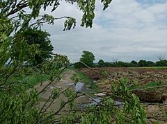
 The field where Skinnand once stood |
|
| OS grid reference | SK9457 |
| • London | 110 mi (180 km) S |
| Civil parish |
|
| District |
|
| Shire county | |
| Region | |
| Country | England |
| Sovereign state | United Kingdom |
| Post town | LINCOLN |
| Postcode district | LN5 |
| Dialling code | 01522 |
| Police | Lincolnshire |
| Fire | Lincolnshire |
| Ambulance | East Midlands |
| EU Parliament | East Midlands |
| UK Parliament |
|
Skinnand was a small village in Lincolnshire, England, that is now empty. It's known as a deserted medieval village because people used to live there a long time ago, but now it's just fields. Skinnand was a farming community with a church and a few houses. It was located about 9 miles (14 km) south of Lincoln.
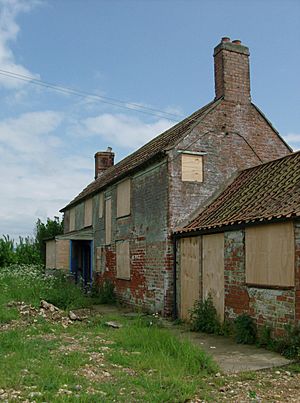
During the English Civil War (1642-1646), the church in Skinnand was destroyed. Today, you'll only find open fields and one old, empty farmhouse where the village once stood.
Contents
History of Skinnand
Early Times in Skinnand
People have lived in the area around Skinnand for a very long time. Archaeologists have found signs of human activity from the Bronze Age, around 600 BC. Remains of Iron Age farms and Roman settlements have also been found nearby.
Skinnand was first written about in the Domesday Book in 1086. This was a huge survey ordered by William the Conqueror to record everything in England. Back then, Skinnand was called "Schinende." Its name might come from an old Scandinavian word, "skinnari," which means "skinner" or "tanner" (someone who prepares animal hides).
Life in the Middle Ages
In 1332, Skinnand was the smallest village in its local area. It had a population of about 40 people and was mostly a farming village. The number of people living in Skinnand stayed about the same for many years.
However, by 1563, only three of the original ten families were left. Some historians think this happened because farmers started raising more sheep instead of growing crops. This meant fewer people were needed to work the land.
Before the English Civil War, Skinnand had up to six houses. Most were small, one-story stone homes with thatched roofs. But two houses were much bigger! One belonged to a man named John Chester and had four main rooms plus "upper chambers" (upstairs rooms). The other large house was the parsonage, where the local priest lived. It had many rooms, including a hall, two sitting rooms, a kitchen, a pantry, a milkhouse, and a place for brewing drinks. It even had a stable, three upstairs rooms, an orchard, a garden, a yard, and a dovecote (a small building for doves).
It's believed the parsonage was torn down during the Civil War. By 1665, when the Hearth Tax (a tax based on the number of fireplaces in a home) was collected, only three houses were left in Skinnand.
The Church of Skinnand
The church in Skinnand was an Anglican church built in the Norman style. It was said to be dedicated to St Matthew. Sadly, it was reportedly burned down by Oliver Cromwell's soldiers in the 1640s during the English Civil War.
Historical records show that the church began to fall apart in the 1600s. A document from 1700 said: "The church was in ruins, no house for the rector, more than this we find not, all the buildings being long since disappeared." Even though the church was gone, people in Skinnand still held services. They met at the home of a local man, John Woolfitt, throughout the 1800s. The Skinnand burial ground was also used until 1911.
Skinnand in the 1800s
In 1801, the Census showed that only 12 people lived in Skinnand. The population grew a little over the next 100 years, reaching 30 people in 1901. But by 1921, the number was dropping again, with only 25 residents.
Most of the men in Skinnand worked as farm laborers. Their children went to school in nearby villages like Wellingore, Carlton-le-Moorland, and Bassingham. These schools were several miles away, so the children had to walk a long distance.
In the mid-1800s, Skinnand was a struggling area. It was part of the Lincoln Poor Law Union, which helped people who were very poor. The village covered about 636 acres (2.57 km²), with some land for crops and most for pasture (where animals graze). Records from 1871 noted that "just a few stones remain to mark the location" of the old church. By that time, the village had only three farms, all owned by Mr. S. Nicholls from London.
The 1900s and Today
By 1911, the population of Skinnand was shrinking again, with just 28 people. Most were tenant laborers, meaning they worked on land owned by someone else. By 1913, William Grant of Grimsby was the main landowner.
The village was lived in for only a few more years after that. The last families moved out, and Skinnand became completely deserted. Today, only one old, boarded-up farmhouse stands where the busy community of Skinnand once was.
How Skinnand Was Governed
Skinnand was part of an old area called a wapentake. This term comes from the Vikings and was used to describe a group of local parishes. It meant "show your weapon," because people would raise their swords or axes to show they agreed with a decision! Skinnand was in the Boothby Graffoe wapentake.
A book from 1834, The History of the County of Lincoln, described this area. It said the Boothby Graffoe wapentake included villages like Boothby, Coleby, Harmston, Navenby, Skinnand, Swinethorpe, Welbourn, and Wellingore.
Skinnand was considered an "ancient parish" from the 11th to the 19th century. This meant it was under the control of a clergyman and existed before 1597. In 1292, the land of Navenby and Skinnand was given to the Dean and Chapter of Lincoln (a group of church leaders). The money from land rent was used to maintain a chapel in Harby, built in honor of Queen Eleanor, wife of King Edward I.
After the 16th century, parishes like Skinnand started taking on more duties, not just church matters. They helped with things like caring for the poor. In 1834, Skinnand became part of the Lincoln Poor Law Union, which managed aid for the poor. On April 1, 1931, Skinnand officially merged with the nearby parish of Navenby.
Over the years, Skinnand was governed by different local councils. From 1894 to 1931, it was part of the Branston Rural District Council. Then, from 1931 to 1974, it was controlled by the North Kesteven Rural District Council. Today, Skinnand is still part of the North Kesteven district.
Voting and Parliament
Before 1832, Lincolnshire sent twelve members to the national parliament. After the Reform Act 1832, the voting areas changed. Skinnand became part of the South Division Parliamentary District for Lincolnshire. Later, it moved to the Mid Division in 1867, then the North Kesteven Division in 1885, and finally the Grantham Division in 1918, until 1974.
Geography of Skinnand
Skinnand is located near an old Roman road called Ermine Street, which locals call High Dyke. This road runs between the nearby villages of Boothby Graffoe, Navenby, and Wellingore.
The Viking Way, a long walking path that stretches 147 miles (237 km) from the Humber Bridge to Oakham, also goes through the area where Skinnand was.
Skinnand is found at 53°06′25″N 0°35′49″W / 53.10694°N 0.59694°W. It sits just below a ridge of Jurassic limestone known as the Lincoln Edge or Lincoln Cliff. This small cliff is one of the few hills in Lincolnshire. Skinnand is about 8.7 miles (14 km) south of Lincoln. The area has warm summers and dry, frosty winters.
During the Ice Age, much of Lincolnshire was covered by ice. This has shaped the land and the types of soil found there. A lot of Lincolnshire is low-lying, and some parts, including Skinnand, are even below sea level. The area around Skinnand and Navenby stretches from east to west, reaching the Lincoln Heath in the east and the River Brant in the west.
 |
Haddington, North Hykeham, Aubourn, Saxilby | Boothby Graffoe, Coleby, Harmston, Waddington, Bracebridge Heath, Lincoln | Blankney, Metheringham, Branston |  |
| Bassingham, Norton Disney, Newark-on-Trent | Navenby, Scopwick, Coningsby, Woodhall Spa, Tattershall | |||
| Brant Broughton, Welbourn, Leadenham | Wellingore, Temple Bruer, Grantham | Digby, Ashby de la Launde, Ruskington |
Climate in Skinnand
The British Isles have a maritime climate, which means they have fairly cool summers and mild winters. Compared to other parts of the UK, Lincolnshire, where Skinnand is located, has slightly warmer and sunnier summers. Its winters are colder and frostier.
Because Skinnand is inland, it's one of the driest places in the UK. It gets less than 3 feet (600 mm) of rain each year on average. The area also gets a good amount of sunshine, about four hours and 12 minutes per day. This is because there isn't any high ground to block the sun.
| Climate data for Skinnand | |||||||||||||
|---|---|---|---|---|---|---|---|---|---|---|---|---|---|
| Month | Jan | Feb | Mar | Apr | May | Jun | Jul | Aug | Sep | Oct | Nov | Dec | Year |
| Mean daily maximum °F | 43 | 44 | 49 | 54 | 60 | 65 | 70 | 70 | 64 | 57 | 48 | 44 | 56 |
| Mean daily minimum °F | 35 | 35 | 38 | 40 | 45 | 50 | 54 | 54 | 51 | 46 | 40 | 37 | 42 |
| Average precipitation inches | 1.45 | 1.08 | 1.04 | 1.46 | 1.13 | 1.51 | 1.7 | 1.45 | 1.61 | 1.83 | 1.51 | 1.38 | 21 |
| Mean daily maximum °C | 6 | 7 | 9 | 12 | 16 | 18 | 21 | 21 | 18 | 14 | 9 | 7 | 13 |
| Mean daily minimum °C | 2 | 2 | 3 | 4 | 7 | 10 | 12 | 12 | 11 | 8 | 4 | 3 | 6 |
| Average precipitation mm | 37 | 27 | 26 | 37 | 29 | 38 | 43 | 37 | 41 | 46 | 38 | 35 | 530 |
| Source: MSN | |||||||||||||
 | William M. Jackson |
 | Juan E. Gilbert |
 | Neil deGrasse Tyson |


