South Stradbroke Island facts for kids
|
Native name:
Minjerribah
Nickname: South Straddie
|
|
|---|---|

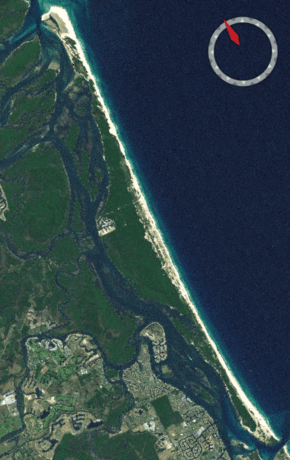
NASA Landsat Image of South Stradbroke
|
|
 |
|
| Geography | |
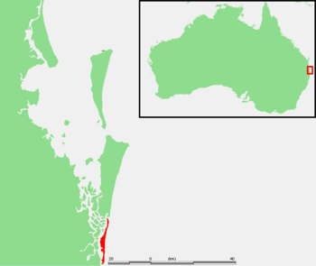
| Location | Moreton Bay |
| Coordinates | 27°50′00″S 153°25′20″E / 27.8333°S 153.4222°E |
| Length | 21 km (13 mi) |
| Width | 2.5 km (1.55 mi) |
| Administration | |
|
Australia
|
|
| State | Queensland |
| Region | Gold Coast, South East Queensland |
| Local government area | City of Gold Coast |
| Demographics | |
| Population | 142 (2021 census) |
| South Stradbroke Queensland |
|||||||||||||||
|---|---|---|---|---|---|---|---|---|---|---|---|---|---|---|---|

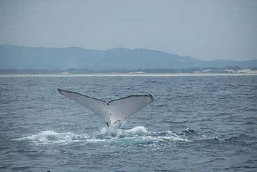
A humpback whale heading north for the winter, off the coast of South Stradbroke
|
|||||||||||||||
| Population | 142 (2021 census) | ||||||||||||||
| • Density | 4.537/km2 (11.75/sq mi) | ||||||||||||||
| Postcode(s) | 4216 | ||||||||||||||
| Area | 31.3 km2 (12.1 sq mi) | ||||||||||||||
| Time zone | AEST (UTC+10:00) | ||||||||||||||
| LGA(s) | City of Gold Coast | ||||||||||||||
| State electorate(s) | Broadwater | ||||||||||||||
| Federal Division(s) | Fadden | ||||||||||||||
|
|||||||||||||||
South Stradbroke Island is an island in Moreton Bay, Queensland, Australia. It is often called South Straddie. The island is part of the Gold Coast area. In 2021, about 142 people lived there.
The island is about 21 kilometers (13 miles) long and 2.5 kilometers (1.6 miles) wide. It is the smaller of the two Stradbroke Islands. South Stradbroke Island is very close to the mainland. It is known for its many wild wallabies. These wallabies are used to people. They sometimes even try to take food from campers!
South Stradbroke Island is one of over 360 islands in Moreton Bay. Its southern end faces the Broadwater. The very tip of the island is near the Gold Coast Seaway, just a few meters from the mainland at Southport Spit. To the northeast, Tipplers Passage separates it from smaller islands. The eastern coast of the island faces the Coral Sea.
The island is mostly made of sand dunes. It also has special rainforests and wetlands. Many unique plants and animals live here. The golden wallaby is only found on this island. The agile wallaby, which used to be common in the area, now mostly lives on South Stradbroke Island.
Contents
Island History
Even before it became a separate island in 1896, the land and waters of South Stradbroke were important to the Quandamooka people. They had lived on the Redland Bay islands for a very long time.
How the Island Was Formed
South Stradbroke Island and North Stradbroke Island were once one big island. This changed in 1896. In 1894, a ship called the Cambus Wallace got stuck during a storm. It was stuck at a narrow part of the island. When people tried to save the ship, they used explosives. This made the sand dunes weak.
By 1896, big storms and tides created a new opening. This opening connected Moreton Bay to the Coral Sea. It is now called the Jumpinpin Channel. This new channel changed the waterways and islands in southern Moreton Bay.
Past Uses of the Island
In the early 1900s, some land was cleared for cattle. From the 1950s to 1960s, people dug for sand on the northern ocean beach. For many years, starting in the 1870s, the island's inner shores were used by people who collected oysters. There was even a small town called Moondarewa at the southern tip. But by 1953, the island's natural movement caused most of the town to wash away.
Filming on the Island
In 2009, parts of the movie The Chronicles of Narnia: The Voyage of the Dawn Treader were filmed on South Stradbroke Island.
Places to Stay and Visit
South Stradbroke Island is a popular place for tourists. Many people visit, especially during holidays.
Camping on the Island
There are several places to camp on the island.
- Tipplers Campsite: This campsite can hold up to 100 tents. It has gas BBQs and a play area for kids. There's also a small shop for camping supplies.
- North and South Currigee Campsites: These two campsites together can hold up to 80 tents. They also have BBQs, a play area, and a small shop.
- Dux Campsite: This campsite is owned by The Southport School.
Couran Cove Island Resort
The Couran Cove Island Resort is on the north side of the island. You can get there by boat from Surfers Paradise in about 40 minutes. The resort has different types of rooms and places to eat. You can also see native Australian animals in the forest. The resort was first opened in 1998. It was designed to be friendly to nature.
Fun Things to Do
There is a large conservation park on the island, covering 1800 hectares (4448 acres). This park is great for seeing native wildlife. You can go hiking and fishing in the ocean.
Other fun activities include:
- Jet ski tours
- Tube rides
- 4WD (four-wheel drive) tours
- Speed boat rides
These activities often start from the Couran Cove Island Resort or Tipplers Passage.
Education on the Island
There are no schools directly on South Stradbroke Island. Children living there would need to travel to schools on the mainland. Another option for learning is Distance education, where students learn from home.
Images for kids
 | Janet Taylor Pickett |
 | Synthia Saint James |
 | Howardena Pindell |
 | Faith Ringgold |


