
St. Louis Gateway Mall facts for kids
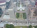
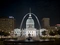
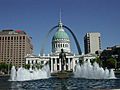
The Gateway Mall in St. Louis, Missouri, is a long, open green space in the city's downtown area. It stretches for about 1.5 miles, from the famous Gateway Arch all the way to Union Station. It's located between Market Street and Chestnut Street.
This mall is like a green ribbon connecting many important places in downtown St. Louis. In recent years, city planners have been working on exciting new ideas to make the mall even better. They want to add more fun things to do and make it a more welcoming place for everyone who visits. The goal is to connect all the cool downtown spots into one big, amazing mall area.
History of the Gateway Mall
Early Ideas for the Mall
The idea for the Gateway Mall started way back in 1907 with a plan called the Comprehensive Plan. This plan was inspired by the "City Beautiful" movement, which aimed to make cities more beautiful and organized with parks and grand buildings. The first idea was to clear buildings between 13th and 14th streets to create a new park. This didn't happen right away.
Later, in 1912, a similar plan called the Central Traffic-Parkway was proposed. It wanted to clear buildings between Tucker and Jefferson avenues to create a one-block-wide park. This plan even hoped to extend the mall all the way to Grand Avenue. Even though the mayor, Henry Kiel, supported it, people voted against it in 1915.
In 1919, the City Plan Commission tried again with the Public Building Plan. This plan suggested clearing land for a park between 12th and 14th streets. Voters finally approved this plan in 1923! They even approved $87 million to buy and tear down properties to make space for these new parks and public areas.
Building the Mall Over Time
In 1939, during the Great Depression, a park was built with federal money. This park was part of what is now the Gateway Arch National Park (then called the Jefferson National Expansion Memorial). It was located between 3rd and 4th streets.
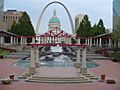
In 1940, a famous artist named Carl Milles was asked to design a fountain called The Meeting of the Waters. This beautiful fountain was placed in Aloe Plaza, right in front of Union Station.
During the 1950s, city leaders finished more park blocks between 15th and 18th streets.
In 1965, voters approved money to build Kiener Plaza between Broadway and 6th street. Even though a plan to extend the mall to Kiener Plaza was voted down in 1966, the city still moved forward. They cleared a block between 10th and 11th streets and created a park space there in 1976. However, this park wasn't very popular and was later changed to be the home of Richard Serra’s large sculpture, Twain.
The Pride Plan and Changes
In 1982, Mayor Vincent Schoemehl introduced the Pride Plan. This plan aimed to remove the remaining buildings in the mall area. The idea was to build smaller, five-story buildings on the northern parts of each block, with parks on the southern parts. Three large, old office buildings were torn down by the end of 1984. Over the next two years, many smaller historic buildings were also demolished, even though they were important enough to be considered for the National Register of Historic Places.
Only one new building was constructed under this plan: the 15-story Gateway One. This building was criticized because it was much taller than planned. It actually blocked the view of the Arch, which the mall was supposed to highlight! Its large size also made the park next to it feel private instead of being part of the public mall.
In 1992, Mayor Schoemehl promised to finish the mall before he left office. By 1994, his team cleared two more blocks between 8th and 10th streets for the mall, which meant tearing down the historic Western Union Building.
The Master Plan for the Future
In 2007, Mayor Francis Slay ordered a new plan for the mall called the Master Plan. This plan imagined the mall as a series of outdoor "rooms," connected by a "hallway" along its southern edge. Each "room" would have a special purpose related to the buildings nearby.
- Near the Twain sculpture, a sculpture park was suggested.
- Near the Library, City Hall, and the Civil Courts Building, a "civic room" for public events was recommended.
- Next to the Plaza Square apartments, a "neighborhood room" with family-friendly facilities was needed.
- At the end near Union Station, a "terminus" section was planned to mark the end of the mall.
These rooms were designed to work together and with the buildings around them.
Citygarden, a sculpture park and one of these "rooms," opened in 2009 and was very popular. After this, a special group was formed to help take care of the mall, raise money, and complete the rest of the Master Plan.
Features of the Gateway Mall
Luther Ely Smith Square

The Luther Ely Smith Square is a park managed by the National Park Service. It's located right between the Gateway Arch grounds and the Old Courthouse. It's named after Luther Ely Smith, who helped organize the competition that led to the design of the Arch.
For a long time, it was hard for people to walk from the city to the Arch because of Memorial Drive (which is part of Interstate 70). The Smith Square was redesigned to fix this problem. In 2015, a new park was built over Interstate 70, finally connecting the Arch grounds directly to the city of St. Louis!
Nearby, you'll find the Hyatt Regency St. Louis Riverfront hotel, the Drury Plaza Hotel, and KMOV-TV.
-
Luther Ely Smith Square as seen from the Gateway Arch

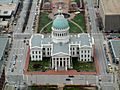
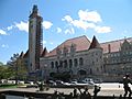
Old Courthouse

The Old St. Louis County Courthouse was once a very important building for both federal and state courts in St. Louis, Missouri. From 1864 to 1894, it was the tallest building in Missouri! Today, it's part of the Gateway Arch National Park.
The land for the courthouse was given in 1816 by Judge John Baptiste Charles Lucas and St. Louis founder René Auguste Chouteau. They wanted the land to be used "forever as the site on which the courthouse... should be erected." The first courthouse was finished in 1828.
The county courts stopped using the building in 1930 when the Civil Courts Building was built. In 1935, during the Great Depression, St. Louis voted to clear almost 40 blocks around the courthouse to create the new Gateway Arch National Park. President Franklin D. Roosevelt officially made the area a national monument. The Old Courthouse became part of this monument in 1940.
The building has been repaired and updated several times over the years. It remained the largest structure in the monument area until the Gateway Arch was completed in 1965.
Important Cases at the Old Courthouse
- In 1846, an enslaved man named Dred Scott and his wife Harriet sued for their freedom in this courthouse. Their owner had taken them to a free territory before bringing them back to Missouri, which was a slave state. In the past, Missouri courts often granted freedom to enslaved people who had lived in free areas. However, as tensions grew between the North and South over slavery, the court ruled against the Scotts. Their case eventually went to the U.S. Supreme Court, which also ruled against them. This ruling said that enslaved people had no rights under the U.S. Constitution and made the Missouri Compromise unconstitutional. This decision made the divide between the North and South even wider, leading up to the American Civil War.
- In 1872, Virginia Minor tried to vote in a St. Louis election but was arrested because women were not allowed to vote yet. Her trials, including those before the Missouri Supreme Court, took place in this building. Her case also went to the United States Supreme Court in a case called Minor v. Happersett, which upheld the rules that only men could vote.
-
View of the Old Courthouse from the top of the Arch. Kiener Plaza is behind it.
-
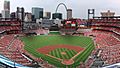
The Courthouse can be seen from Busch Stadium
-
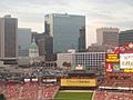
Seen from Busch Stadium
-


Kiener Plaza

Kiener Plaza covers the entire width of the mall between 7th Street and Broadway. It's located just north of the St. Louis Ballpark Village, which was built recently. The land for Kiener Plaza is owned by a private company but leased to the city of St. Louis.
In 2009, a St. Louis architecture firm called HOK offered to redesign Kiener Plaza for free. Their plan was to make it more attractive and a more active public space for everyone to enjoy.
-
Kiener Plaza as seen from the Arch in 2004
-
The Running Man sculpture in Kiener Plaza
-
The Running Man
-
Sunken section of Kiener Plaza


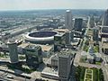
Gateway One

Built in the 1980s, Gateway One replaced three older buildings that were part of the mall area. It was built on the northern part of its block, with a park on the southern half. The original idea was to bring businesses to the mall with new buildings, but to keep them a moderate size. However, Gateway One ended up being much taller than planned. Its large size makes the park next to it feel like a private area instead of a public part of the Gateway Mall. It also blocks some of the view of the Arch. Gateway One is the main office for Peabody Energy.
To the north of Gateway One is the Wainwright Building, designed by the famous architect Louis Sullivan. To the south is 700 Market Street.
-
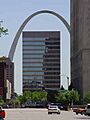
View of Peabody headquarters on the Gateway Mall.

Citygarden

Citygarden is a special park in the city that features many sculptures. It was a gift from the Gateway Foundation in 2009. You can find art by many famous sculptors here, including Keith Haring, Jim Dine, and Niki de Saint Phalle.
Richard Serra's Twain
This huge sculpture by Richard Serra takes up an entire block. It was designed especially for its spot and is meant to give people different views and ideas as they walk around it. It used to be in a green space by itself, which didn't get many visitors. There are plans to make this sculpture more accessible to the public and connect it better to Citygarden.
Nearby, you'll find the AT&T Center and the Southwestern Bell Building to the north. To the south are the Bank of America building and the KSDK TV and Cable Studios, and further south is the Thomas F. Eagleton Federal Courthouse.
-
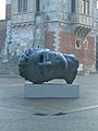
Igor Mitoraj's Eros Bendato was shown in Poland before coming to Citygarden.

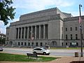
Civil Courts Building

The Civil Courts Building (sometimes called the St. Louis Pyramid) is a landmark court building used by the 22nd Judicial Circuit Court of Missouri in St. Louis.
With its unique pyramid-shaped roof, this building is often seen in photos of the Gateway Arch from the Illinois side. It's perfectly lined up in the middle, right behind the Old Courthouse.
This building was part of a big plan in 1923 to build impressive public buildings along the Memorial Plaza, including Kiel Auditorium and the Municipal Services Building. This was part of St. Louis's City Beautiful plan, aiming to create a grand center for important city functions.
It replaced the Old Courthouse as the main court building for the city and county. Its construction even led to a lawsuit from the descendants of Auguste Chouteau, who had given the land for the Old Courthouse. They wanted the Old Courthouse back since it wasn't being used for courts anymore, but they didn't win their case.
The pyramid roof was designed to look like the Mausoleum of Maussollos, which was one of the Seven Wonders of the Ancient World. It has 32 tall Ionic columns (8 on each side), made of Indiana limestone.
The roof itself is made of cast aluminum and has two 12-foot-high sphinx-like statues on top. These statues have the fleur-de-lis (a symbol of St. Louis) on their chests and were sculpted by Steven A. Rebeck.
To the south of the Civil Courts Building is the Mel Carnahan Courthouse, which is the federal courthouse.
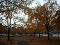
Civic Room

The Civic Room is a large green space made up of five blocks. It surrounds the Soldier's Memorial and the War Memorial, and it's next to the downtown Central Library. The plan is for the Civic Room to become the main place for outdoor festivals and events in the city. Chestnut Street will be closed for three blocks to create space for a fountain and event tents. An outdoor stage is also planned. This area is located between 12th and 15th streets, and between Market and Olive streets.
In the middle of the Civic Room is Soldier's Memorial Plaza. To the north, you'll find the Central Library. The Washington Avenue Loft District runs parallel to the mall beyond that, along with the New Life Evangelistic Center and The Jefferson Arms apartments. To the south of these park blocks are the Peabody Opera House and St. Louis City Hall, which is designed in a French Gothic style.
Central Library
The Central Library, designed by Cass Gilbert, is located just across Olive Street from the Civic Room.
Soldiers Memorial
Soldiers Memorial is like an island surrounded by the Civic Room.
Peabody Opera House
The Peabody Opera House is an important building in this part of the mall. It also helps take care of the park grounds next to it.
-
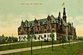
City Hall in 1907
-
The Peabody Opera House across Market Street


Neighborhood Room

The Neighborhood Room currently covers two blocks, between 15th and 18th streets. It's next to the residential Plaza Square apartments and the downtown post office. This section of the mall is meant to be a place for people who live nearby, with facilities for families like sand-volleyball courts and youth soccer fields.
To the north is Plaza Square, an apartment complex built in the 1960s. To the south are the Abrams Federal Building and the St. Louis Post Office.
-
The Neighborhood Room in 2005.
-
Looking down Market Street from 18th street.
-
Looking down Chestnut Street at dawn from 17th street.
-
The Post Office as seen from a balcony in Plaza Square


Terminus

The Terminus section stretches from 18th Street west to the I-64 exit ramps. It includes Aloe Plaza and the Carl Milles fountain, The Meeting of the Waters. This fountain represents St. Louis's location where the Missouri and Mississippi rivers meet. The westernmost block in the Terminus is currently a park that is hard to access. The Master Plan suggests building an observation mound here in the future, similar to the ancient Monk's Mound of Cahokia, which was a major city of the Native American Mississippian culture.
To the south of the Terminus is Union Station.
Union Station
Union Station was once a very busy railroad station. After changes in train travel, it was redeveloped into a place with shops, restaurants, and a Marriott Hotel. It also has a Hard Rock Cafe, a lake, and a MetroLink (light rail) stop.
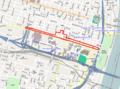
I-64 Interchange
In the original St. Louis highway plan, there was supposed to be another highway connecting to I-64 here. The interchange is there, but the highway was never built. This area will be redeveloped as a job center as part of the NorthSide project. It should have a new boundary at 22nd Street.
-
Phase 1 of the NorthSide TIF plans a redevelopment of the I-64 interchange at the Terminus
-
Union Station across Market Street from the Milles' fountain on the Gateway Mall


Images for kids
-

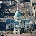
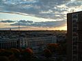
Aerial view of the mall looking east
-
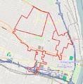
Map of Gateway Mall in downtown St. Louis


