
St Mary's, Isles of Scilly facts for kids
Quick facts for kids St Mary's
|
|
|---|---|
 Porthcressa, showing part of Hugh Town |
|

St Mary's
|
|
| Population | 1,723 (2011) |
| OS grid reference | SV915115 |
| Civil parish |
|
| Unitary authority | |
| Ceremonial county | |
| Region | |
| Country | England |
| Sovereign state | United Kingdom |
| Post town | ISLES OF SCILLY |
| Postcode district | TR21 |
| Dialling code | 01720 |
| Police | Devon and Cornwall |
| Fire | Isles of Scilly |
| Ambulance | South Western |
| EU Parliament | South West England |
| UK Parliament |
|
St Mary's, also known as Ennor in Cornish (meaning 'The Mainland'), is the biggest and most populated island in the Isles of Scilly. This group of islands is located off the southwest coast of Cornwall, England.
Contents
Discover St Mary's Island

St Mary's covers an area of about 6.58 square kilometers (2.54 square miles). This is 40 percent of all the land in the Isles of Scilly. The island also includes four small tidal islands. These islands connect to St Mary's when the tide is low. They are Toll’s Island, Taylor’s Island, Newford Island, and the island at Innisidgen.
St Mary's has a population of 1,723 people. This is out of a total population of 2,203 for all the Isles of Scilly. Most residents live in the western part of the island. The main town, Hugh Town, has 1,097 people living there.
Hugh Town (called Tre Huw in Cornish) was sold to its residents by the Crown in 1949. Before that, it belonged to the Duchy of Cornwall. The Duchy still owns much of the rest of the island. Other villages on St Mary's include Old Town, Porthloo, Pelistry, Trenoweth, Holy Vale, Maypole, Normandy, Longstone, Rocky Hill, and Telegraph.
British Prime Minister Harold Wilson lived on St Mary's. He was also buried at the cemetery at Old Town Church after he passed away in 1995.
Local Government and Wards
St Mary's is one of the five civil parishes in the Isles of Scilly. These parishes are also called wards. St Mary's sends 12 councillors to the Council of the Isles of Scilly. The other four islands each send 1 councillor. The civil parish does not have its own council or meetings.
Getting Around St Mary's
St Mary's is the only island in the Isles of Scilly with a big road network. It also has public roads, including three 'A' roads. These roads are the A3110, A3111, and A3112, and they are about 4.7 miles long in total. The roads are more like country lanes. Roads and streets on Scilly have very few signs or markings. Road numbers are not shown at all.
In 2005, there were 619 cars and vans on St Mary's. The island also has taxis and a guided bus tour. Vehicles on Scilly do not need annual MOT tests.
Air Travel to St Mary's
St Mary's Airport serves the island by air. Currently, only fixed-wing aircraft fly here. Isles of Scilly Skybus operates these flights. They fly to and from Land's End, Newquay, and Exeter (except in winter). Helicopter services used to run from Penzance Heliport. This service stopped in October 2012.
Sea Travel to St Mary's
The Isles of Scilly Steamship Company provides passenger and cargo services from Penzance. The Scillonian III passenger ferry operates this route. The Gry Maritha cargo vessel also helps. Other islands are connected to St Mary's by a network of inter-island launches. The main harbor of St Mary's is in Hugh Town. It is called St Mary's Harbour. Other small quays and slipways are found around the island. These include Old Town, Pendrathen, Watermill Cove, and Porthloo.
The RNLI Lifeboat Station

The RNLI has had a lifeboat station on St Mary's since 1837. The first two lifeboats were kept in a boathouse on the beach in Hugh Town. The station closed in 1855 but reopened in 1874. A new boathouse was built at Porth Cressa. In 1899, a new boathouse and slipway were built at Carn Thomas. The first motor lifeboat arrived in 1919.
The lifeboat crew members of St Mary's have received 26 RNLI medals for bravery. These include one gold, nine silver, and 16 bronze medals. The last medal was awarded in 2004.
Churches on St Mary's
For the Anglican churches, you can look up St Mary's Church, St Mary's and St Mary's Old Church, St Mary's.
John Wesley preached here on September 13, 1743. The Wesleyan Methodist Society started in 1788. Their first chapel was built in 1790. It was replaced in 1828. The current Methodist church was built in 1899 by A.J. Trenear in Hugh Town. It is part of the Isles of Scilly Methodist Circuit.
Famous Landmarks to Explore
Telegraph Tower
The tower on Newford Down is now called Telegraph Tower. It was built in 1814 as an Admiralty Telegraph Station. But it closed by 1816. The building then went back to the landowner, the Duke of Leeds. In 1831, the Coastguard took over the site. They used it as a smaller station to the main one on the Garrison. In 1903, a wireless mast and office were built nearby. In 1908, a telegraph house was put on the tower's roof. The area became a modern radio and communications site by the late 20th century. The tower is now a private home. Around 1898, Guglielmo Marconi heard wireless signals here. They were sent from Porthcurno, 30 miles away. Radio Scilly also used this tower for broadcasting.
Harry's Walls

Harry's Walls are the remains of a castle that was never finished. It is on a hilltop northeast of Hugh Town. Construction began in 1551. It was part of a big project to build defenses on the Isles of Scilly. This was to protect against threats from the French. The castle was left unfinished because the location was not good for a fort.
Giant's Castle

Giant's Castle is an Iron Age cliff castle. You can find it on the coastal path between the airfield and Porth Hellick Bay.
The Garrison and Star Castle
Star Castle is the center of a defense system. This system is around the west side of St Mary’s and is called the Garrison. The castle walls are shaped like an eight-pointed star. It has an outer wall around Hew Hill. This wall protects the town and the castle. There are also gun batteries placed along the outer wall. These batteries allow for covering fire from all directions. An old windmill was turned into Garrison Tower after 1831. It became a lookout tower for HM Coastguard.
The Star Castle was built in 1593 by Robert Adams. He was a surveyor and mapmaker. Francis Godolphin directed the building. This happened after the Spanish Armada in 1588. Queen Elizabeth I feared another Spanish invasion. So, in May 1593, she ordered a fort and two sconces to be built. These were for spotting any enemy ships.
In 1740, Master Gunner Abraham Tovey changed the Garrison walls. He added gun batteries, like Colonel Boscawen's Battery. These were in a circular shape along the coastline of The Hoe. Star Castle is now a hotel.

Peninnis Head Lighthouse
The 14-meter metal tower lighthouse on Peninnis Head was built in 1911. It replaced an older lighthouse from 1680 in the center of St Agnes. The lighthouse changed from gas to electricity in 1992. Its original light range was 17 nautical miles. This was reduced to nine in 2011. The headland is part of the Isles of Scilly Area of Outstanding Natural Beauty. It is also part of the Heritage Coast. It is a Geological Conservation Review site. It is known for its Quaternary geomorphology. It was first named a Site of Special Scientific Interest (SSSI) in 1971. This was for both its plants, animals, and geology.
Porthellick Cove Memorial

Porthellick Cove has a memorial. It marks where the body of Admiral Sir Cloudesley Shovell was found. This happened after the 1707 Scilly naval disaster. This was one of the biggest maritime disasters in British history. Four ships and nearly 2,000 sailors were lost. The ships were the Association, Firebrand, Romney, and Eagle.
Other Interesting Places
Here are some other places you can visit on St Mary's:
- Lower Moors Nature Reserve
- Higher Moors Nature Reserve (near Porth Hellick)
- Holy Vale
- Porthloo Beach
- Watermill Cove
- Innisidgen Burial Chamber
- Isles of Scilly Golf Club, located near Telegraph and Porthloo
Population Changes Over Time
- 1841 – 1,519 people (plus 26 in the Garrison)
- 1861 – 1,424 people
- 1871 – 1,368 people
- 1881 – 1,290 people
- 1891 – 1,201 people
- 1901 – 1,355 people
- 1911 – 1,376 people
- 1921 – 1,196 people
- 1931 – 1,216 people
- 1951 – 1,625 people
- 1961 – 1,736 people
- 1971 – 1,958 people
- 1981 – 2,073 people
- 1991 – 1,600 people
- 2001 – 1,666 people
- 2011 – 1,723 people
Education on St Mary's
Five Islands Academy (formerly Five Islands School) has a campus on St. Mary's. It includes both primary and secondary school levels. A boarding house, Mundesley Boarding House, is available for secondary students from other islands. Students who are at the sixth-form college level live and study elsewhere, on mainland Great Britain.
St. Mary's Library is located on the Porthcressa seafront.
The Carn Gwaval Wellbeing Centre offers adult further education programs.
Images for kids
-
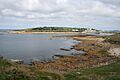
The Garrison, historically "the Hugh", looking across Porth Cressa
-
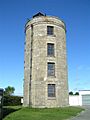
Telegraph Tower
-
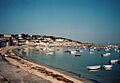
Hugh Town
-
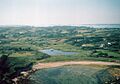
St Mary's from an aerial perspective; looking north from Porth Hellick up the Holy Vale
-
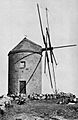
Spanish Windmill


See also
 In Spanish: Saint Mary's (Islas Sorlingas) para niños
