Stony Point, New York facts for kids
Quick facts for kids
Stony Point, New York
|
||
|---|---|---|
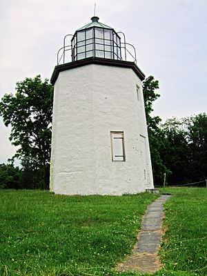
Stony Point Light in Stony Point
|
||
|
||
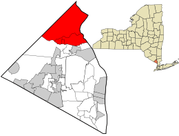
Location in Rockland County and the state of New York.
|
||
| Country | United States | |
| State | New York | |
| County | Rockland | |
| Established | March 20, 1865 | |
| Area | ||
| • Total | 31.60 sq mi (81.84 km2) | |
| • Land | 27.62 sq mi (71.54 km2) | |
| • Water | 3.98 sq mi (10.30 km2) | |
| Elevation | 282 ft (86 m) | |
| Population
(2020)
|
||
| • Total | 14,813 | |
| • Density | 536.31/sq mi (207.06/km2) | |
| Time zone | UTC-5 (EST) | |
| • Summer (DST) | UTC-4 (EDT) | |
| ZIP code |
10980
|
|
| Area code(s) |
|
|
| FIPS code | 36-71674 | |
| GNIS feature ID | 0979532 | |
| Website | http://www.townofstonypoint.org | |
Stony Point is a town located in Rockland County, New York, United States. It is part of the larger New York City area. The town sits north of Haverstraw, and is bordered by Orange County to the east and south. To the west, you'll find the Hudson River and Westchester County.
In 2020, about 14,813 people lived here. The town's name comes from a rocky area that sticks out into the Hudson River. Stony Point is in the northeastern part of Rockland County. Major roads like U.S. Route 9W, U.S. Route 202, and the Palisades Interstate Parkway run through it. Stony Point is also part of the North Rockland Central School District. It is known as the most rural of the five towns in Rockland County.
Contents
History of Stony Point
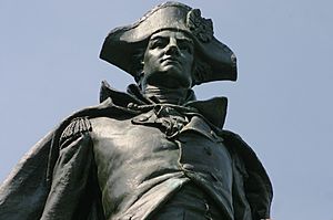
Stony Point has a rich history, especially during the American Revolution. The King's Ferry, located here, was a vital link. It connected New York and the southern colonies with New England. General George Washington's Continental Army used it many times. In 1781, Washington's French allies crossed here on their way to the important Battle of Yorktown.
The town of Stony Point was officially created in 1865. It was formed from the northern part of the town of Haverstraw. The local economy grew in the 1800s when new limestone deposits were found.
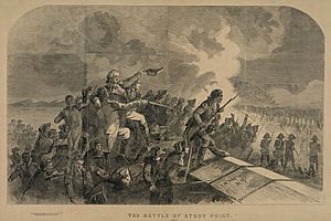
The Battle of Stony Point
Controlling Stony Point was very important during the American Revolution. General George Washington himself knew how crucial it was to keep this area safe. It was key to protecting West Point, a vital military post. Washington put Major Henry Lee and General Anthony Wayne in charge of taking back the area.
Having control of Stony Point helped Washington communicate better between different colonies. The town's natural features, like its rocky terrain and woods, made it a good spot to watch over the Hudson River. General Wayne planned a smart attack and carried it out well.
British troops held Stony Point, but Washington wanted it back. Taking control would give the Americans an advantage over the strong British navy. While not the final battle, it played a big part in the American Revolution's outcome.
During the Battle of Stony Point, soldiers used different weapons. Bayonets were very common. British soldiers often used the sword attached to their rifles. Even though it sounds strange, bayonets were very effective if soldiers knew how to use them. Rifles at that time had some problems, like being too light. General Wayne told his soldiers to use muskets and bayonets instead of rifles for this reason.
There's a story about an African-American slave named 'Pompey' who may have helped the American cause. Some historians say Pompey wanted to help the American troops win. He supposedly sold food, like strawberries, to the British soldiers. He would talk to them and gather information, including a secret password to enter the fort at night. He then shared this with the American troops. This allowed General Wayne to launch a surprise night attack on the British at Stony Point. However, a senior historian at the Stony Point Battlefield State Historic Site says this story is likely a myth.
Geography
Stony Point covers about 31.6 square miles (81.8 square kilometers). Most of this, about 27.6 square miles (71.5 square kilometers), is land. The rest, about 4.0 square miles (10.3 square kilometers), is water.
The western edge of the town is the border with Orange County. The eastern edge is along the Hudson River. On the other side of the river is Westchester County.
Education
The Town of Stony Point is part of the North Rockland Central School District. This district offers schooling for all ages. Students attend elementary school from kindergarten to 5th grade. Then they go to middle school for 6th through 8th grade. Finally, high school covers 9th through 12th grade. The average SAT score for students in the town is usually over 1000.
Schools located within Stony Point include:
- Farley Upper Elementary School
- Fieldstone Middle School
- Haverstraw Upper Elementary School
- Immaculate Conception School
- North Rockland High School
- Stony Point Elementary School
- Thiells Elementary School
- West Haverstraw Elementary School
- Willow Grove Upper Elementary School
Demographics
| Historical population | |||
|---|---|---|---|
| Census | Pop. | %± | |
| 1870 | 3,205 | — | |
| 1880 | 3,308 | 3.2% | |
| 1890 | 4,641 | 40.3% | |
| 1900 | 4,161 | −10.3% | |
| 1910 | 3,651 | −12.3% | |
| 1920 | 3,211 | −12.1% | |
| 1930 | 3,458 | 7.7% | |
| 1940 | 4,898 | 41.6% | |
| 1950 | 5,485 | 12.0% | |
| 1960 | 8,739 | 59.3% | |
| 1970 | 12,704 | 45.4% | |
| 1980 | 12,838 | 1.1% | |
| 1990 | 12,814 | −0.2% | |
| 2000 | 14,244 | 11.2% | |
| 2010 | 15,059 | 5.7% | |
| 2020 | 14,813 | −1.6% | |
| U.S. Decennial Census | |||
As of the 2020 Census, there were 14,813 people living in the Town of Stony Point. In 2000, there were 14,245 people and 4,832 households. About 38% of households had children under 18 living with them. Most households (66.2%) were married couples. The average household had 2.92 people.
The population was spread out by age. About 26.1% were under 18 years old. About 11.8% were 65 years or older. The average age was 38 years.
Communities and Locations in Stony Point
Stony Point is home to several smaller communities and interesting places:
- Bear Mountain – A small community in the northern part of town. It is named after a peak in the Bear Mountain State Park.
- Bulsontown – A community in the northwestern part of the town.
- Cedar Flats – A community located northwest of the main Stony Point area.
- Doodletown – A community in the northern corner of the town. It is inside Bear Mountain State Park and has been abandoned since 1965.
- Grassy Point – A community and a short piece of land that sticks into the Hudson River.
- Jones Point – A community right by the Hudson River. It is the easternmost community in Stony Point.
- Stony Point – This is the main community and census-designated place in the eastern part of the town.
- Tomkins Cove – A community by the Hudson River, just north of the town of Stony Point.
- Willow Grove – A community on the southern border of the town. It includes Jessup Valley, a small area around Jessup Lake.
Transportation
The old New York Central's River Subdivision train line runs along the west bank of the Hudson River through Stony Point. Today, CSX Transportation operates this line. The only company in town served by CSX is the Mirant Lovett Generating Station. This power station receives trainloads of coal about once a week. The power station has its own railroad to bring the coal from the main line into the plant.
A special device called a "talking defect detector" is in Stony Point. It checks the axles of passing trains for problems. On average, 20 to 25 trains pass through Stony Point every day. CSX runs six container trains daily. Once a week, a garbage train from the Bronx brings trash north to be burned for power. Most days, you will see freight trains and tanker cars on the River Line. The Auto Rack express brings cars to their owners in New Jersey or northern New York. CSX trains usually run five to fifteen minutes apart, with the longest wait being about an hour. There are only two train bridges in Stony Point.
The Palisades Interstate Parkway also goes through the town.
Tourism
Historical Markers
You can find several historical markers in Stony Point that tell about its past:
- Buckberg Mountain, at 112 Buckberg Mountain Road.
- Site of King's Ferry, at Route 9W & Park Road. This was a very important river crossing during the American Revolution. It connected New England with the southern states. This is why capturing Stony Point from the British in 1779 was so important.
- Site of Springsteel Farm House 1779, at 16A Franck Road.
- Washington Wayne Lookout.
- Wilson H. Young Memorial Bridge, on East Main Street.
- Stony Point Battlefield, at Route 9W & Park Road. This site was held by the British in 1779.
- The First Road, at 117 W. Main Street.
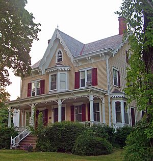
- Gilmor Sloane House – This building was built in 1856 by Benjiman F. Goodspeed. It was designed in the French Renaissance style.
Landmarks and Places of Interest
Stony Point has many interesting places to visit:
- Berlin Wall segment – You can see a piece of the Berlin Wall outside the Stony Point Justice Court.
- Gilmor Sloane House – Located at 17 Crickettown Rd. This is a Victorian mansion built in 1856. It has no televisions or telephones, offering a step back in time. There's also an 1888 Barn Playhouse (Penguin Rep) on the property.
- Harriman State Park – A large state park that extends into the western part of the town.
- Iona Island and Marsh – Found between Jones Point and Bear Mountain. It used to be called "Weyants Island."
- Patriot Hills Golf Club – This golf course was ranked among the best public golf courses in New York in 2010 by Golf Magazine.
- Pyngyp School – A historic school building.
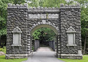
- Stony Point Battlefield – A state historic site off Route 9W. It was taken by the British in 1779. It is listed on the National Register of Historic Places.
- Stony Point Light – This lighthouse opened in 1826. In the 1800s and early 1900s, lighthouses on the Hudson River helped ships travel safely. The Hudson River is one of New York State's largest rivers, stretching from New York City to Albany. It had 13 lighthouses in total. The Stony Point lighthouse is on the Stony Point Battlefield and is still open for visitors.
- William H. Rose House – Another historic house listed on the National Register of Historic Places.
Notable People
Many interesting people have connections to Stony Point:
- John Cage (1912–1992) – A famous composer who lived in Stony Point in the 1950s and 60s.
- Stephanie Courtney (1970–) – An actress and comedian, known for playing "Flo" in commercials. She was born in Stony Point.
- James Farley (1888–1976) – A Postmaster General and Chairman of the Democratic National Committee.
- Heinz Hartmann (1894-1970) – An Austrian-born psychiatrist and psychoanalyst who passed away in Stony Point.
- Richard Humann (1961–) – A conceptual artist who was born and grew up in Stony Point.
- Jasper Johns (1930–) – A well-known artist who lived in Stony Point in the 1980s and 1990s.
- Karen Karnes (1925–2016) – A potter who lived and worked at the Gate Hill Cooperative in Stony Point for 25 years.
- Danielle McEwan (1991–) – A professional ten-pin bowler and title holder in the Professional Women's Bowling Association.
- Mitch Miller (1911–2010) – A musician and record producer who owned a house in Stony Point.
- Roy Pea (1952–) – A learning scientist and professor at Stanford University.
- Katelyn Tuohy (2002–) – A middle and long-distance runner. She is a four-time NCAA champion and holds the national women's high school mile record.
- Stan Vanderbeek (1927–1984) – An independent filmmaker who built his Movie Drome theater in Stony Point.
- General "Mad" Anthony Wayne (1745–1796) – A United States Army officer and statesman. He may have gotten his nickname "Mad" at the Battle of Stony Point during the Revolutionary War.
See also
 In Spanish: Stony Point (Nueva York) para niños
 | William Lucy |
 | Charles Hayes |
 | Cleveland Robinson |


