Thargomindah facts for kids
Quick facts for kids ThargomindahQueensland |
|||||||||||||||
|---|---|---|---|---|---|---|---|---|---|---|---|---|---|---|---|

Outback roadhouse of Thargomindah
|
|||||||||||||||
| Population | 243 (2021 census) | ||||||||||||||
| • Density | 0.01597/km2 (0.0414/sq mi) | ||||||||||||||
| Established | 1860s | ||||||||||||||
| Postcode(s) | 4492 | ||||||||||||||
| Elevation | 130 m (427 ft) | ||||||||||||||
| Area | 15,213 km2 (5,873.8 sq mi) | ||||||||||||||
| Time zone | AEST (UTC+10:00) | ||||||||||||||
| Location |
|
||||||||||||||
| LGA(s) | Shire of Bulloo | ||||||||||||||
| County | Wellington | ||||||||||||||
| State electorate(s) | Warrego | ||||||||||||||
| Federal Division(s) | Maranoa | ||||||||||||||
|
|||||||||||||||
|
|||||||||||||||
Thargomindah /ˈθɑːrɡoʊmɪndə/, often called Thargo, is a small town in the Shire of Bulloo, Queensland, Australia. It is the main town for the Bulloo Shire area. In 2021, about 243 people lived in Thargomindah.
In 2020, the Queensland Government changed the local areas in the Shire of Bulloo. Thargomindah's area grew much larger. It now covers about 15,213 square kilometres.
Contents
- Thargomindah: A Town in Outback Queensland
Thargomindah: A Town in Outback Queensland
Where is Thargomindah?
Thargomindah is in South West Queensland. It is about 1,000 kilometres west of Brisbane, the state capital. The town is also about 200 kilometres west of Cunnamulla.
The town is the main centre for the Shire of Bulloo. It sits right on the Bulloo River. This river flows through the middle of the area.
Five main roads lead out from Thargomindah:
- The Bundeena Road goes west to Noccundra.
- The Quilpie Road heads north-east to Quilpie.
- The Cunnamulla Road goes east to Yowah and Eulo. It then continues to Cunnamulla.
- The Hungerford Road goes south to Hungerford.
- The Bulloo Downs Road leads south-west to Bulloo Downs.
Thargomindah is part of the Channel Country. Here, rivers are often dry. They only fill up when there are seasonal floods. Water from this area flows into three big river systems. These are the Paroo River (part of the Murray–Darling basin), the Bulloo River (in the Bulloo-Bancannia drainage basin), and the Wilson River (part of the Lake Eyre basin).
The land around Thargomindah is mostly used for raising cattle.
Nature and Parks Around Thargomindah
Lake Bindegolly National Park is located to the east of the town. A part of the Currawinya National Park is also near the south-eastern edge.
Lake Bullawarra is in the north-west. It is about 25 kilometres north-west of Thargomindah. This lake is an important wetland for Australia. It is home to the Major Mitchell's cockatoo, a bird that needs protection.
A Look Back: Thargomindah's History
Early Days and First Explorers
Thargomindah is on the traditional land of the Kalali people. They were connected to other groups like the Wongkumara and Badjiri peoples. Their languages, like Margany and Kalali, are mostly gone now.
British explorers arrived in the early 1860s. Vincent James Dowling started the Thargomindah cattle property in 1865. The town of Thargomindah grew around a police barracks built on Dowling's land. The name Thargomindah comes from an Aboriginal word for echidna.
A post office opened in 1870. A telegraph line connected the town to Cunnamulla in 1881. Thargomindah Provisional School started in 1884. It became Thargomindah State School in 1892.
In the 1890s, the town grew as a centre for the surrounding cattle farms. There were plans to extend the Western railway line to Thargomindah. However, this never happened. The railway did reach Cunnamulla in 1898 and Quilpie in 1917.
Power from Water: Thargomindah's Special Story
Thargomindah was one of the first towns in Australia to use hydroelectric power. This happened from 1898 until 1951. They used water from a bore that tapped into the Great Artesian Basin. The natural pressure of the water turned a turbine. This turbine then made electricity for the street lights.
This was the first power plant owned by a local council. After 1951, diesel generators provided power. In 1988, the town connected to the main state power grid. The old power station is still there and open for visitors.
Who Lives in Thargomindah?
In 2006, Thargomindah had 203 people. By 2016, the population grew to 270 people. In the most recent count in 2021, there were 243 people living in Thargomindah.
What Can You Find in Thargomindah?
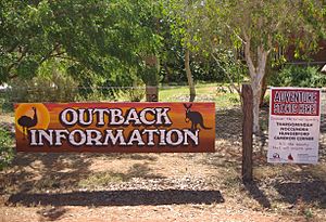
Thargomindah has an information centre at 37 Dowling Street. This building used to be a children's hostel in the 1960s. It is now a modern centre with a Visitor Information Centre, a Library, and a Coffee Shop. The hostel was a place for children from remote farms to stay during the week for school.
The Information Centre offers maps and details about the area. It is a great first stop for visitors.
The Bulloo Shire Council runs the Thargomindah Library. It is located at the Shire Office on Dowling Street.
For fuel, there are two stations: Thargo Motors and Thargo Roadhouse. Thargo Roadhouse offers 24-hour fuel using card payments.
If you need a place to stay, you can find the Oasis Motel, Bulloo River Hotel Motel, Explorers Caravan Park, and Napunyah Caravan Park. For dining, you can eat at the Oasis Motel, Bulloo River Hotel Motel, Coffee on Dowling, or Thargo Roadhouse.
Learning in Thargomindah
Thargomindah State School is a government primary school. It teaches children from Early Childhood to Year 6. It is located on Dowling Street. In 2018, the school had 24 students.
For older students (Years 8–12), the closest government secondary school is Cunnamulla P–12 State School.
Water from Deep Underground
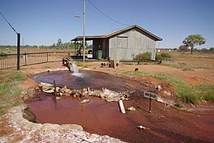
Thargomindah gets its water from a hot spring. This spring comes from a bore that goes deep into the Great Artesian Basin. This bore also helped produce hydroelectric power in the past. Water was found in 1893 after two years of drilling. The water was very hot, about 86°C (187°F).
Today, the bore still provides a lot of water. It is about 84°C (183°F). This means there is plenty of water for the town. It also helps with irrigation for gardens. There are even public warm showers available.
Getting Around Thargomindah
Thargomindah Airport is north of the town on Kerr Street. The Bulloo Shire Council manages it. There are two flights from Brisbane each week with Regional Express Airlines. The airport has a sealed runway that is 1,463 metres long. It also has an unsealed runway that is 846 metres long. The airport was fully rebuilt in 2018.
There is also the Dynevor Downs Airport. It has three unsealed runways. The longest is about 1,050 metres.
Thargomindah's Weather
Thargomindah has a hot, semi-dry climate. This means it is very close to being a hot desert climate. Summers are very hot and usually dry. Sometimes, heavy rain comes during the monsoon season. Winters are warm and dry, but mornings can be cool or cold.
| Climate data for Thargomindah | |||||||||||||
|---|---|---|---|---|---|---|---|---|---|---|---|---|---|
| Month | Jan | Feb | Mar | Apr | May | Jun | Jul | Aug | Sep | Oct | Nov | Dec | Year |
| Record high °C (°F) | 48.8 (119.8) |
46.0 (114.8) |
43.8 (110.8) |
38.9 (102.0) |
32.2 (90.0) |
30.4 (86.7) |
28.5 (83.3) |
36.3 (97.3) |
39.2 (102.6) |
41.2 (106.2) |
45.4 (113.7) |
45.0 (113.0) |
48.8 (119.8) |
| Mean daily maximum °C (°F) | 38.5 (101.3) |
36.0 (96.8) |
33.5 (92.3) |
29.5 (85.1) |
23.8 (74.8) |
20.0 (68.0) |
20.1 (68.2) |
22.9 (73.2) |
27.8 (82.0) |
31.1 (88.0) |
33.8 (92.8) |
36.4 (97.5) |
29.5 (85.1) |
| Mean daily minimum °C (°F) | 25.5 (77.9) |
24.0 (75.2) |
21.2 (70.2) |
16.6 (61.9) |
10.6 (51.1) |
7.5 (45.5) |
6.7 (44.1) |
8.3 (46.9) |
12.8 (55.0) |
16.6 (61.9) |
20.6 (69.1) |
23.0 (73.4) |
16.1 (61.0) |
| Record low °C (°F) | 17.2 (63.0) |
12.3 (54.1) |
9.4 (48.9) |
6.5 (43.7) |
1.0 (33.8) |
−0.8 (30.6) |
−0.9 (30.4) |
0.1 (32.2) |
4.7 (40.5) |
6.2 (43.2) |
9.7 (49.5) |
13.7 (56.7) |
−0.9 (30.4) |
| Average rainfall mm (inches) | 39.1 (1.54) |
47.9 (1.89) |
45.5 (1.79) |
17.5 (0.69) |
14.4 (0.57) |
16.7 (0.66) |
13.6 (0.54) |
8.0 (0.31) |
9.8 (0.39) |
14.1 (0.56) |
40.7 (1.60) |
30.3 (1.19) |
300.4 (11.83) |
| Average rainy days (≥ 0.2 mm) | 3.6 | 4.5 | 4.4 | 1.4 | 2.8 | 3.9 | 3.5 | 2.0 | 2.6 | 3.4 | 5.5 | 4.4 | 42 |
 | Janet Taylor Pickett |
 | Synthia Saint James |
 | Howardena Pindell |
 | Faith Ringgold |


