Tocorpuri facts for kids
Quick facts for kids Tocorpuri |
|
|---|---|
| Tocopuri | |

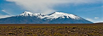
View from the south-west.
|
|
| Highest point | |
| Elevation | 5,808 m (19,055 ft) |
| Dimensions | |
| Area | 11 km2 (4.2 sq mi) |
| Geography | |
| Country | Chile |
| Geology | |
| Age of rock | Pleistocene |
| Volcanic field | Altiplano-Puna volcanic complex |
| Last eruption | 34,000 ± 7,000 years |
Tocorpuri is a volcano located in Chile, very close to the border with Bolivia. Its highest point is about 5,808 metres (19,055 ft) tall. At its top, it has a large summit crater that is about 1.3 kilometres (0.81 mi) wide.
This volcano is mostly made up of hardened lava flows and rock fragments from past eruptions. It actually has two main parts. To the west of Tocorpuri, there's a unique structure called the La Torta lava dome. It's about 200 metres (660 ft) high and has a flat top, looking a bit like a cake! The rocks that make up these volcanoes are types called andesite, dacite, and rhyolite.
The Tocorpuri volcanoes formed a long time ago, during the late Pleistocene period. They went through three main stages of development. They were also shaped by glaciation (ice ages) and movements in the Earth's crust called faulting. The most recent eruption happened about 34,000 years ago, creating the La Torta lava dome. Today, there's still geothermal activity (heat from inside the Earth) nearby, which might be linked to the famous El Tatio geothermal field.
Contents
Exploring Tocorpuri's Shape
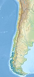
Tocorpuri is in northern Chile, about 100 kilometres (62 mi) east of a city called Calama. The border between Chile and Bolivia actually runs right around the eastern side of Tocorpuri's top crater. This area is part of Chile's Antofagasta Department and Bolivia's Sur Lipez Department. An old road, used by people long before Europeans arrived, passes south of the volcano. This road connected the Bolivian Altiplano (high plains) with the San Pedro de Atacama region. It's one of the oldest road systems in Chile! The name "Tocorpuri" comes from the Kunza language.
Tocorpuri volcano is actually a group of three different parts. East Tocorpuri is the tallest at 5,808 metres (19,055 ft). It rises about 1 kilometre (0.62 mi) above the land around it. A large, slightly oval-shaped crater, about 1.3 kilometres (0.81 mi) wide, sits on its summit. From the top of Tocorpuri, you can see the huge Salar de Atacama salt flat and the Chuquicamata mine, which is the biggest copper mine in the world! You can also find Sulfur deposits near the summit, which were mined in the past.
Some of the other craters on Tocorpuri are very old and worn down. You can see old, eroded lava flows on the southern side, while newer, smaller flows are near the top. West Tocorpuri is mostly made of blocky lava flows, especially on its western side. East Tocorpuri has lava flows, pyroclastic deposits (rock fragments), and tuff-like breccia (rock made of broken pieces). There's also evidence that a large part of Tocorpuri's southeast side once collapsed, leaving a horseshoe-shaped scar. Tocorpuri is part of the main chain of volcanoes along the border between Chile and Bolivia.
The La Torta Lava Dome
The La Torta (which means "the cake" in Spanish) lava dome is located between Tocorpuri volcano to the east and Tatio volcano to the west. It's a flat-topped structure, about 200 metres (660 ft) high, with steep sides. It covers an area of about 11 square kilometres (4.2 sq mi) on flat ground. Its sides are covered with loose rock, while its top has wavy patterns from the cooling lava. The dome reaches a height of 5,018 metres (16,463 ft). Scientists have found two different vents and two different types of rock layers on La Torta. Even though they are 10 kilometres (6.2 mi) apart, La Torta and Tocorpuri are sometimes called a "volcano pair."
Ice from Glacial periods has carved into the sides of these volcanoes. You can see moraines (piles of rock left by glaciers) and mudflow deposits at the base of La Torta. On the Tocorpuri volcanoes, there are cirques (bowl-shaped hollows carved by glaciers) and glacial striations (scratches on rocks from moving ice). In the past, a glacier even filled the crater of Tocorpuri!
Climate and Water Around Tocorpuri
The area around Tocorpuri has a high-altitude steppe climate. This means it's generally cool, with an average temperature of about 2 °C (36 °F). However, the temperature can change a lot between day and night, sometimes by 20 °C (36 °F)!
Not much rain falls here, but on the summit, it's estimated to get over 360 millimetres (14 in) of precipitation each year. South of Tocorpuri, about 159 millimetres (6.3 in) falls annually. Most of this rain happens in the summer as convective precipitation (like thunderstorms). Snow has been seen on the summit, and an old map from 1985 even showed a permanent ice or snow cover there. The Putana River, south of Tocorpuri, flows towards the Salar de Atacama. It gets important water from streams in the Tocorpuri area, like Quebrada La Torta and Rio Blanco.
How Tocorpuri Formed
Off the western coast of South America, a huge piece of the Earth's crust called the Nazca Plate is slowly sliding underneath the South America Plate. This process is called subduction. This movement is what causes most of the volcanoes in the Andean Volcanic Belt, which Tocorpuri is a part of.
The Altiplano-Puna volcanic complex (APVC) has been active on and off for millions of years. In the late Pleistocene period, around 100,000 to 90,000 years ago, several large lava domes like Tocorpuri were formed. These domes are part of a line that follows the edge of a huge ancient volcano called the Pastos Grandes caldera. Today, volcanism in the area mostly creates many volcanic cones.
Most of the region is covered by old volcanic ash and rock called ignimbrites. However, the area right on the border between Bolivia and Chile has newer volcanoes from the Quaternary period. The way the Earth's crust is cracked and lined up (called lineaments) has affected how these volcanoes, including Tocorpuri, developed. La Torta, for example, formed at the end of a thrust fault, which might have been the path for magma to rise to the surface.
What Tocorpuri Rocks Are Made Of
The rocks from Tocorpuri volcano are mostly andesite, dacite, and rhyolite. These rocks are rich in potassium. Inside these rocks, you can find different types of crystals, like biotite, clinopyroxene, hornblende, orthopyroxene, and plagioclase. These crystals vary depending on the specific rock type. Scientists think these rocks formed as magma cooled and crystals separated. The rocks near the summit have been changed by hot water and steam from inside the volcano. The La Torta dome's rock composition is similar to other large lava domes in the APVC.
Hot Springs and Geothermal Activity
Tocorpuri is known to have solfataric activity, which means it releases volcanic gases and steam. There are also hot springs, gas vents, and bubbling pools at about 5,000 metres (16,000 ft) elevation north of La Torta. The famous El Tatio geothermal field and the Sol de Manana geothermal field are also nearby. Some scientists believe that El Tatio gets its heat from a hot rock reservoir located under La Torta. Companies are even looking into using the geothermal heat in the El Tatio-La Torta area to generate power.
Tocorpuri's History
Volcanic activity in this area started about 800,000 years ago. Tocorpuri itself formed in four main stages. The first two stages built the two main Tocorpuri volcanoes. The third stage produced lava flows that came out of cracks on Tocorpuri's southern and northwestern sides. The fourth stage created the La Torta dome. One scientist, Déruelle, thought that East Tocorpuri was actually newer than La Torta or West Tocorpuri.
Between these stages of volcanic activity, the volcanoes were shaped by movements in the Earth's crust. Thrusts (where rocks are pushed over each other) and normal faults (where rocks pull apart) have shifted the ground around and on Tocorpuri, even affecting its summit and crater.
The Story of La Torta
Scientists have found different ages for La Torta, some less than a million years old, and one around 101,000 years old. It was even thought to be from the Holocene period (the last 11,700 years) because it sits on top of older glacial deposits. But later, using a method called Argon-argon dating, scientists determined its age to be about 34,000 ± 7,000 years old.
The La Torta lava dome formed from a type of eruption called an effusive eruption, where lava flows out slowly. It seems to have formed in a single event, possibly starting with some small explosions. Scientists are still debating whether the volcanism at La Torta and other nearby lava domes is just the last bit of activity from the old APVC, or if it's the start of a whole new cycle of magma rising to the surface. La Torta has also been suggested as a possible vent for a very old eruption (about 700,000 years ago) that created the Tatio ignimbrite. The actual vent for that eruption is probably buried under the Tatio volcanoes.
See also
 In Spanish: Cerros de Tocorpuri para niños
- List of volcanoes in Bolivia
- List of volcanoes in Chile
- Putana Volcano
- Sairecabur
- Laguna Colorada
 | Anna J. Cooper |
 | Mary McLeod Bethune |
 | Lillie Mae Bradford |


