
Tomifobia River facts for kids
Quick facts for kids Tomifobia River |
|
|---|---|

Meandering between the hamlets of Tomifobia and Boynton
|
|

|
|
| Native name | Rivière Tomifobia |
| Country | Canada |
| Province | Quebec |
| Region | Estrie |
| MRC | Memphrémagog Regional County Municipality |
| Municipality | Barnston-Ouest, Hatley |
| Physical characteristics | |
| Main source | Barnston-Ouest 489 m (1,604 ft) 45°02′43″N 71°56′27″W / 45.045306°N 71.940966°W |
| River mouth | Saint-François River Hatley 160 m (520 ft) 45°11′15″N 72°01′33″W / 45.1875°N 72.0257°W |
| Length | 10.8 km (6.7 mi) |
| Basin features | |
| Progression | Saint-François River, Saint Lawrence River |
| Tributaries |
|
The Tomifobia River is a beautiful freshwater river in Quebec, Canada. It flows through the Memphremagog Regional County Municipality in the Eastern Townships. A small part of the river even forms a border between Canada and the United States near Beebe Plain, Vermont.
Contents
Explore the Tomifobia Nature Trail
The Tomifobia Nature Trail is a fun place to visit. It is about a 15-minute drive from Magog, Quebec. This trail is 19 kilometres (12 mi) long. It connects Lake Massawippi (near Ayer's Cliff, Quebec) to Beebe Plain, Vermont. The trail follows the west side of the Tomifobia River. It also goes through Stanstead, Quebec, which is close to the Quebec-Vermont border.
This trail is part of a 140-acre park. It also connects to other trails in Vermont. People use the trail for many activities. In spring, summer, and fall, you can go cycling, hiking, or running. In winter, it is great for cross-country skiing. It is also a wonderful place to watch wildlife and enjoy nature. You can see the Tomifobia River flowing through the valley. Thousands of visitors come here every year. There are three parking lots in Ayer's Cliff to help people access the trail.
The River's Journey: Course of the Tomifobia

The Tomifobia River is the main source of water for Lake Massawippi. This lake was once called Lake Tomifobi. When the water leaves Lake Massawippi, it becomes the Massawippi River. The Massawippi River then flows into the Saint-François River.
The areas around the Tomifobia River are mostly protected. This means there is not much building along the riverbanks. This helps keep the river clean and natural. Only near Lake Massawippi in Ayer's Cliff, Quebec are there more houses.
The lands next to the Tomifobia River's water system include:
- To the North: Lake Massawippi
- To the East: Niger River and water from Lyster Lake
- To the South: Johns River (Vermont) and Clyde River (Vermont)
- To the West: Lake Memphremagog
River's Water System: Watershed
A small part of the river's water system reaches into Vermont in the United States. Land in Vermont that drains into the Tomifobia River includes parts of Derby, Holland, and a small area of Norton. This also includes Holland and Beaver Ponds.
Scientists have studied the river. They found that the Tomifobia delta, where the river meets Lake Massawippi, has grown over time. This growth happens mostly during big floods, not from everyday farming. However, farming can cause high levels of phosphates in the lower parts of the river after heavy rains.
Animals and Plants: Natural History
The Tomifobia River is home to many kinds of fish. You can find brook trout, grey trout, brown trout, and rainbow trout. There are also landlocked atlantic salmon, walleye, small-mouth bass, and mullet.
The wetlands in the Tomifobia valley are special. They are part of the Appalachian Corridor Appalachien (ACA). Rare animals live here, including the endangered wood turtle. You might also see bald eagles flying overhead. In the water, you can spot North American river otters and North American beavers.
River's Past: History

The name "Tomifobia" comes from the Algonquian languages. These were spoken by the Abenaki tribes. They used to travel along the lakes and rivers in the Eastern Townships long ago. The Tomifobia River was an important path. It connected the Connecticut and Saint Lawrence river systems. It is one of the few southern rivers that flows north into the Saint Lawrence River.
The Abenaki people were allies with France during the French and Indian Wars. The Tomifobia valley was part of New France until 1763. That year, the Treaty of Paris gave the region to the English. Before 1900, maps sometimes called it the "Barlow River."
In the late 1700s, after the Constitutional Act of 1791, United Empire Loyalists settled in the Tomifobia River valley. Mills were built along the river in the early 1800s. These mills helped towns like Boynton, Tomifobia (once called Smith's Mills), and Stanstead Plain (Kilborn's Mills) grow. These villages became important stops for stagecoaches and later for trains. The Massawippi Valley Railroad became part of the Boston and Maine Railroad in 1867.
The 19-kilometre (12 mi) Tomifobia Nature Trail used to be a railway line. It runs along much of the river between Ayer's Cliff, Quebec and Beebe Plain. It passes through the small towns of Tomifobia and Boynton.
What People Do There: Economy and Activities
In the past, mills along the river and farming were the main ways people made a living. Today, the Tomifobia River is a popular place for tourists. In the summer, you can go canoeing or kayaking, cycling, hiking, and bird watching. It is also a good spot for fishing. In the winter, people enjoy cross-country skiing and snowshoeing.
Images for kids
-
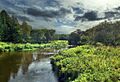
Meandering between the hamlets of Tomifobia and Boynton
-
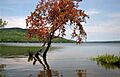
The Tomifobia River starting its journey at Lake Massawippi
-
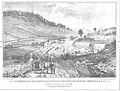
Kilborn's Mills on the Tomifobia, Stanstead County (around 1830). These mills were built in 1803 by Colonel Charles Kilborn.
