Trinity County, Texas facts for kids
Quick facts for kids
Trinity County
|
|
|---|---|

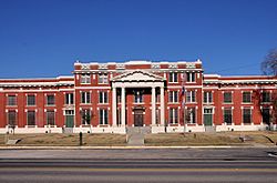
The Trinity County Courthouse in Groveton
|
|

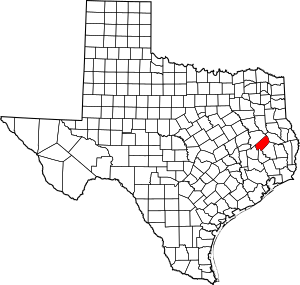
Location within the U.S. state of Texas
|
|
 Texas's location within the U.S. |
|
| Country | |
| State | |
| Founded | 1850 |
| Named for | Trinity River |
| Seat | Groveton |
| Largest city | Trinity |
| Area | |
| • Total | 714 sq mi (1,850 km2) |
| • Land | 694 sq mi (1,800 km2) |
| • Water | 20 sq mi (50 km2) 2.9% |
| Population
(2020)
|
|
| • Total | 13,602 |
| • Density | 19.050/sq mi (7.355/km2) |
| Time zone | UTC−6 (Central) |
| • Summer (DST) | UTC−5 (CDT) |
| Congressional district | 17th |
Trinity County is a special area in the state of Texas, USA. It's like a large district with its own local government. In 2020, about 13,602 people lived here. The main town, or county seat, where the county government is located, is Groveton. The county gets its name from the Trinity River, which is a big river in Texas.
Trinity County is also part of the Huntsville, TX area. This means it's connected to Huntsville for things like jobs and business.
Contents
About the Land
Trinity County covers a total area of 714 square miles. Most of this land, about 694 square miles, is dry land. The rest, about 20 square miles, is water, like rivers and lakes. This means about 2.9% of the county is covered by water.
Neighboring Counties
Trinity County shares its borders with several other counties:
- Angelina County (to the northeast)
- Polk County (to the southeast)
- San Jacinto County (to the south)
- Walker County (to the southwest)
- Houston County (to the northwest)
Protected Natural Areas
Part of the Davy Crockett National Forest is located within Trinity County. This is a large forest area protected by the government.
Who Lives Here?
Demographics is the study of people in a certain area, like their age, race, and how many there are. Here's how the population of Trinity County has changed over the years:
| Historical population | |||
|---|---|---|---|
| Census | Pop. | %± | |
| 1860 | 4,392 | — | |
| 1870 | 4,141 | −5.7% | |
| 1880 | 4,915 | 18.7% | |
| 1890 | 7,648 | 55.6% | |
| 1900 | 10,976 | 43.5% | |
| 1910 | 12,768 | 16.3% | |
| 1920 | 13,623 | 6.7% | |
| 1930 | 13,637 | 0.1% | |
| 1940 | 13,705 | 0.5% | |
| 1950 | 10,040 | −26.7% | |
| 1960 | 7,539 | −24.9% | |
| 1970 | 7,628 | 1.2% | |
| 1980 | 9,450 | 23.9% | |
| 1990 | 11,445 | 21.1% | |
| 2000 | 13,779 | 20.4% | |
| 2010 | 14,585 | 5.8% | |
| 2020 | 13,602 | −6.7% | |
| U.S. Decennial Census 1850–2010 2010 2020 |
|||
This table shows the different groups of people living in Trinity County. It helps us understand the mix of cultures and backgrounds.
| Race / Ethnicity (NH = Non-Hispanic) | Pop 2000 | Pop 2010 | Pop 2020 | % 2000 | % 2010 | % 2020 |
|---|---|---|---|---|---|---|
| White alone (NH) | 11,289 | 11,819 | 10,533 | 81.93% | 81.04% | 77.44% |
| Black or African American alone (NH) | 1,635 | 1,377 | 1,086 | 11.87% | 9.44% | 7.98% |
| Native American or Alaska Native alone (NH) | 50 | 57 | 29 | 0.36% | 0.39% | 0.21% |
| Asian alone (NH) | 31 | 36 | 30 | 0.22% | 0.25% | 0.22% |
| Pacific Islander alone (NH) | 0 | 0 | 4 | 0.03% | 0.00% | 0.03% |
| Other Race alone (NH) | 1 | 13 | 33 | 0.01% | 0.09% | 0.24% |
| Mixed Race or Multiracial (NH) | 105 | 166 | 573 | 0.76% | 1.14% | 4.21% |
| Hispanic or Latino (any race) | 668 | 1,117 | 1,314 | 4.85% | 7.66% | 9.66% |
| Total | 13,779 | 14,585 | 13,602 | 100.00% | 100.00% | 100.00% |
In 2000, there were 13,779 people living in the county. There were 5,723 households, which are groups of people living together in one home. About 25.70% of these households had children under 18. The average household had 2.38 people.
The population was spread out by age. About 22.90% were under 18 years old. The median age, which is the middle age of all people, was 43 years.
Learning and Schools
Trinity County has several school districts that serve its students:
- Apple Springs Independent School District
- Groveton Independent School District
- Trinity Independent School District
- Centerville Independent School District
A small part of Kennard ISD, which is mostly in Houston County, also reaches into Trinity County. For higher education, the county is served by Angelina College.
Getting Around
Main Roads
These are the most important highways that run through Trinity County:
Train Lines
The Union Pacific company runs a freight train line that goes from north to south through Trinity County. This line is used to transport goods.
Towns and Communities
Trinity County has several towns and smaller communities.
Cities
Census-Designated Place
- Westwood Shores (This is a community that is like a town but not officially incorporated as one)
Smaller Communities
Old or Abandoned Towns
Some towns in Trinity County are now ghost towns, meaning they are no longer inhabited:
See also
 In Spanish: Condado de Trinity (Texas) para niños


