
Ute Mountain Ute Tribe facts for kids
Quick facts for kids
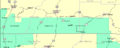
Ute Mountain Reservation
|
|||
|---|---|---|---|
|
|||

Location of the Ute Mountain Reservation
|
|||
| Constitution | 1940 | ||
| Seat of Government | Towaoc, Colorado | ||
| Government | |||
| • Body | Tribal Administration Department | ||
| Area | |||
| • Total | 2,238 km2 (864 sq mi) | ||
| Population
(2020)
|
|||
| • Total | 1,656 | ||
| Time zone | MST/MDT | ||
| Website | [1] | ||


The Ute Mountain Ute Tribe (pronounced "yoot") is one of three federally recognized tribes of the Ute Nation. Most members are descendants of the historic Weeminuche Band. They moved to the Southern Ute reservation in 1897.
Their main office is in Towaoc, Colorado. This town is located on the Ute Mountain Ute Indian Reservation. The reservation covers parts of southwestern Colorado, northwestern New Mexico, and small areas of Utah.
Contents
A Look Back: Ute Mountain Ute History
The Ute Mountain Ute Tribe comes from the Weeminuche band. This group lived west of the Great Divide. Their lands included the Dolores River area in western Colorado. They also lived near the Abajo Mountains and the San Juan River. In 1897, they moved to the Southern Ute reservation.
About 2,000 years ago, Utes lived across the Colorado Plateau. This area includes parts of eastern Utah and western Colorado. It also covers northern Arizona and northwestern New Mexico. Utes were hunters and gatherers. They moved on foot to find food based on the season.
Men hunted animals like deer, antelope, and buffalo. They also hunted rabbits and birds. Women gathered plants such as grass, nuts, berries, and roots. They used woven baskets for collecting. They also prepared and stored food for winter. Utes in the western areas lived in wickiups and ramadas. In the eastern parts, they used hide tipis.
-
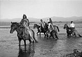
Utes on horseback in the 1890s
-
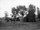
A Ute wickiup, used in western areas
-
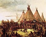
Tipis painted by George Catlin. He visited tribes in the 1830s.


Today, the Ute people have much less land than they once did. This is due to American expansion. The Ute people are divided into three main groups:
- The Ute Indian Tribe of the Uintah and Ouray Reservation in northeastern Utah.
- The Southern Ute in southwestern Colorado near Ignacio.
- The Ute Mountain Ute Tribe, based in Towaoc, Colorado. This article focuses on them.
Utes Meet Spanish Explorers
The Mesa Verde Region is where the Ute Mountain Ute Tribe lives today. This area was the northern edge of Spain's colonial lands. Spanish explorers first came to the American Southwest in 1540. However, they did not settle in New Mexico until 1598. They built their first capital near the pueblo of Ohkay Owingeh.
In 1626, the Spanish first wrote about the Utes. Around 1640, Utes began trading with the Spanish for horses. Spanish traders visited Ute villages. Utes also traveled to New Mexican towns. They traded animal skins, dried meats, and furs. In return, they received horses, knives, and blankets. Spain and the Utes signed their first peace treaty in 1670.
In 1776, two priests, Francisco Atanasio Domínguez and Silvestre Vélez de Escalante, left Santa Fe. They explored Ute territory to find a route to Spanish missions in California. They traveled through western Colorado and Utah. They wrote about the land, animals, and old stone ruins. They also noted signs of precious metals. The men turned back at Salt Lake Valley due to hunger and sickness. Their journey created the route known as the Old Spanish Trail.
-
Domínguez and Escalante's route in 1776
-
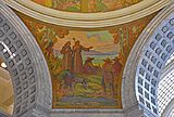
A mural of Fathers Dominguez and Escalante


The Adams–Onís Treaty of 1819 set a border between Spanish and United States lands. Spanish territory included much of the western Rocky Mountains. Even with this border, Spain did not control its northern areas well. When Mexico became independent from Spain, these Spanish lands became Mexican.
Utes and American Settlers
American fur trappers came into the western frontier in 1811. They met the Utes. The Santa Fe Trail opened in 1821. Goods then moved through Ute territory more often. William Bent and Ceran St. Vrain built Bent's Fort in 1834. It was a trading post on the Santa Fe Trail.
In 1848, the Treaty of Guadalupe Hidalgo ended the Mexican–American War. New Mexico and southern Colorado became part of the United States. The next year, the first U.S. treaty was made with Utes. Utes accepted U.S. authority. The U.S. agreed to pay Utes money each year for peace. Americans asked Southern Utes to help them in disagreements with the Navajos. The Utes saw this as a way to get what they needed. In 1868, both the Navajo and Ute tribes were moved to reservations.
As more Americans moved west, disagreements grew. Forts were built, and Utes lost land. Their hunting and gathering grounds became smaller. Many Utes also suffered from illness and lack of food. Between 1859 and 1879, the Ute population dropped from 8,000 to 2,000. In 1868, a treaty limited Utes to the western third of Colorado Territory. In 1873, gold and silver were found in the San Juan Mountains. The Utes gave up this mining area to the U.S. This was one-fourth of their remaining lands.
-

The Colorado Mineral Belt

In 1880, Chief Ouray and other Ute leaders went to Washington, D.C. They wanted to make a new treaty. In 1888, the United States took more Ute lands. In 1895, a new law set up a permanent reservation. The following year, land was given to individual Southern Utes. The tribe moved to the western end of the Southern Ute Reservation in 1897. They were led by Chief Ignacio.
In 1905, the U.S. Government created new reservations. They gave 80 to 160 acres for farming. This greatly reduced Ute land. It also limited their water access and ranching. The rest of the land was opened to white settlers. In 1918, the Consolidated Ute Indian Reservation was formed.
By 1934, a reservation was set up in southwestern Colorado for Southern Utes. It was a dry strip of land. In 1937, the Restoration Act returned 222,000 acres to Southern Utes. In 1938, 30,000 acres were returned to Ute Mountain Utes.
Living on the Ute Mountain Ute Reservation

The Ute Mountain Ute Indian Reservation is in southwestern Colorado and northwestern New Mexico. It covers about 553,008 acres. This land belongs to the Ute Mountain Ute Tribe. However, the U.S. Government holds it "in trust." This means the government manages it for the tribe.
The reservation is in Montezuma and La Plata counties in Colorado. It is also in San Juan County, New Mexico. There are also lands owned by individuals in Utah. Most people on the reservation live in Towaoc. This town is also home to the Ute Mountain Indian Agency.
The reservation's height above sea level changes a lot. It goes from about 4,600 feet near the San Juan River. It rises to about 9,977 feet at the top of Ute Mountain. The land includes Sleeping Ute Mountain, the Mancos River, and high mesas. It also has semi-desert grasslands. Highways 160 and 491 cross the reservation. There are also gravel roads and off-road trails.
In 2000, the population was 1,687 people.
Exploring Ute Mountain Tribal Park

The Ute Mountain Tribal Park is part of the Ute Mountain Ute Indian Reservation. It covers about 125,000 acres along the Mancos River. This park protects hundreds of ancient sites. These include cliff dwellings, rock carvings, and wall paintings. They show the history of the Ancestral Puebloan and Ute cultures.
Native American Ute tour guides lead visitors through the park. They share information about the people and history of the land. National Geographic Traveler named it one of the "80 World Destinations for Travel in the 21st Century." It was one of only nine places chosen in the United States.
Important Ute Leaders
In 1880, Chief Ouray went to Washington, D.C. He was part of the Ute group trying to make a treaty. He passed away that same year at age 47. Chief Jack House was the last traditional chief of the Utes. He died in 1971.
-
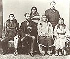
From left: Chief Ignacio, Carl Shurz, Chief Ouray and his wife, Chipeta. Woretsiz and General Charles Adams (Colorado Indian agent) are standing. This photo was taken in 1880.
-
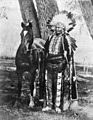
Chief Ignacio in 1904


Images for kids
-
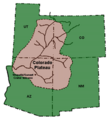
The Colorado Plateau
-
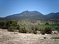
Ute Mountain, part of the Sleeping Ute Mountain range
-
Map of Ute Mountain Ute, Southern Ute and Navajo reservations


