
Victoria Harbour (British Columbia) facts for kids
Quick facts for kids Victoria Harbour |
|
|---|---|
 |
|
| Location | |
| Country | Canada |
| Location | Victoria, British Columbia |
| Coordinates | 48°25′16″N 123°23′34″W / 48.42111°N 123.39278°W |
| Details | |
| Operated by | Transport Canada |
| Size of harbor | 250 ha (620 acres) |
| Harbour master | Michael Sylvester |
| Chair of GVHA | Bill Wellburn |
| Statistics | |
| Vessel arrivals | 202 cruise ships in 2008 228 cruise ships in 2009 at Ogden Point (excludes ferries) |
| Passenger traffic | 380,000 cruise ship passengers in 2008 400,000 cruise ship passengers in 2009 at Ogden Point (excludes ferry passengers) |
| Website Transport Canada & Public Port Traffic Scheme |
|
Victoria Harbour is a busy and important waterway in Victoria, British Columbia, Canada. It's not just a harbour for ships, but also a seaplane airport! Many cruise ships and ferry boats bring tourists and visitors to the city and Vancouver Island. It's a special "port of entry" and "airport of entry" for planes and boats coming into Canada. In the past, it was a big center for building ships and for commercial fishing. The harbour is divided into different parts, with some areas bordering the city of Victoria and others touching nearby towns like Esquimalt and Saanich. The Canadian government, through Transport Canada, manages Victoria Harbour.
Contents
Discovering Victoria Harbour's Past
_and_Geo_E_Starr_in_Victoria_BC_1880s_a_00154.JPG)
Long before Europeans arrived, the Coast Salish Songhees and Esquimalt people lived around the harbour. They grew plants like camas root and oak trees. Old shell piles along the Gorge Waterway show that people have lived here for at least 4000 years!
In 1790, Spanish explorers like Manuel Quimper explored the Strait of Juan de Fuca and claimed nearby Esquimalt Harbour for Spain.
The 1800s: A Time of Growth

In 1843, James Douglas decided to build an outpost for the Hudson's Bay Company on Vancouver Island. He chose the spot overlooking Victoria Harbour for Fort Victoria.
In 1850, a British naval ship, HMS Driver, arrived in the harbour to celebrate Richard Blanshard becoming the first Governor of the new Colony of Vancouver Island.
Sailors from another British ship, HMS Thetis, built a trail in 1852 connecting Esquimalt Harbour with Fort Victoria. This trail is now a paved road called Old Esquimalt Road.
The first lighthouses on Canada's west coast, Fisgard Light and Race Rocks Light, were built near the harbour entrances in 1859 and 1860. They still help guide ships today!

The Fraser Canyon Gold Rush (1858) and Cariboo Gold Rush (1861-1862) brought many people through Victoria Harbour. People came to Fort Victoria to get permits and supplies before heading to the mainland. Victoria officially became a city in 1862.
Captain William Moore moved to Victoria in 1858 and built many barges and steamships. He was involved in trade during the gold rushes, including the Klondike Gold Rush.
Captain William Irving started a ferry service between New Westminster and Victoria in 1859. His son, Captain John Irving, later expanded the family's shipping business. In 1882, he helped create the Canadian Pacific Navigation Company (CPNC). One of their ships, Yosemite, set a speed record from Vancouver to Victoria in 1883, completing the journey in just four hours and 20 minutes!
_and_schooner_Marguerite_at_Victoria_BC_1890s.JPG)
In 1860, a 14-year-old American boy named Charles Mitchell, who might have been a runaway slave, was found on a ferry arriving in Victoria. People in Victoria protested his confinement, and after legal steps, he was set free in Canada.
In 1863, carpenters in Victoria formed one of British Columbia's first trade unions. Also, the Albion Iron Works started, which later became the Victoria Machinery Depot shipbuilding company. They launched their first tugboat, Princess, in 1888.
In 1865, the British Royal Navy moved its Pacific fleet headquarters to Esquimalt Harbour. This allowed Victoria's harbour to focus more on business and trade.
A shipyard started at Point Hope on the Upper Harbour in 1873. Today, it's known as Point Hope Maritime and is still active.
The large building at 1002 Wharf Street, built in 1876, was originally a customs house. It later became known as the Malahat Building.
In 1888, the first railway bridge crossed the harbour, bringing train service to Victoria. Today, the Johnson Street Bridge carries the railway and opened in 1924.
The Royal Victoria Yacht Club, the oldest sailing group in Western Canada, was founded in 1892. They moved to a new clubhouse in Oak Bay in 1913 to enjoy sailing away from the busy harbour.
.jpg)
Construction of the beautiful British Columbia Parliament Buildings, overlooking the Inner Harbour, began in 1893 and opened in 1898.
The 1900s: Modernizing the Harbour

A stone causeway was built across James Bay starting in 1901, making it easier to get around.
After buying the Canadian Pacific Navigation Company in 1901, the Canadian Pacific Railway built the famous Empress Hotel overlooking the Inner Harbour, which opened in 1908. Their ships used to travel between Victoria, Vancouver, and Seattle.
In 1901, Captain John Voss and Norman Luxton sailed from Oak Bay in a small dugout canoe called Tilikum to travel around the world! You can see Tilikum today at the Maritime Museum of British Columbia.
To attract more ships after the Panama Canal opened in 1914, Victoria built the breakwater and piers at Ogden Point between 1916 and 1918. A large grain storage bin was built there in 1925 to ship grain from the Canadian Prairies worldwide.
In 1923, a large part of Victoria Harbour was made a federal Migratory Bird Sanctuary to protect birds.
The first floatplane landed in Victoria in 1919, starting a new airmail service. In 1931, the Imperial Oil Causeway Garage opened with a tall tower that served as a light for planes to land in the harbour at night.

During World War II, the Victoria Machinery Depot built 25 ships for the war effort, including warships and cargo ships. In 1942, a Victoria-built warship, HMCS Quesnel, helped rescue the crew of the Fort Camosun after it was attacked by a submarine.
After the war, commercial fishing grew, and a new Fisherman's Wharf was built in 1948 to support the fishing boats.
From 1954 to 1964, the Canadian Navy reserve unit HMCS Malahat used the old customs house at 1002 Wharf Street. This building is the oldest federal building still standing in Western Canada.
In 1968, Victoria Machinery Depot launched its last vessel, the MV Doris Yorke.

In 1977, a big fire destroyed many buildings at Ogden Point. The last lumber shipping company in Victoria Harbour went out of business in 1984.
The Canadian Coast Guard station opened at the Outer Wharves in 1980. In 1990, the BC Packers' fish factory closed down.
In 1997, students and teachers from Lester B. Pearson College started managing the Race Rocks Lighthouse.
The 2000s: A New Era
In 2001, the Norwegian Sky became the first weekly cruise vessel to visit Ogden Point.
The Greater Victoria Harbour Authority (GVHA) was formed in 2002 to manage and develop many of the harbour's facilities.
Victoria Harbour has also hosted sailing events, including the Clipper Round the World Yacht Race in 2005-2006.
Exploring the Harbour's Parts
Victoria Harbour is made up of several connected waterways: the Outer Harbour, Middle Harbour, Inner Harbour, James Bay, Upper Harbour, Selkirk Water, Gorge Waters, and Portage Inlet.
The active parts of the harbour, where large and mid-sized ships can go, stretch for about 4 kilometers (2.5 miles). The width of the harbour changes, from about 0.74 kilometers (0.46 miles) at the entrance to 137 meters (449 feet) in the Middle Harbour. The water depth varies from about 6 meters (20 feet) to 20 meters (66 feet) in the Inner Harbour.
Outer Harbour
The Outer Harbour is the entrance area. It has a large docking facility at Ogden Point for cruise ships and cable-laying ships.
Middle Harbour
|
Victoria Harbour (Shoal Point) Heliport
|
|||||||||||
|---|---|---|---|---|---|---|---|---|---|---|---|
| Summary | |||||||||||
| Airport type | Private | ||||||||||
| Owner | Canadian Coast Guard | ||||||||||
| Serves | Victoria Harbour | ||||||||||
| Location | Shoal Point | ||||||||||
| Time zone | PST (UTC−08:00) | ||||||||||
| • Summer (DST) | PDT (UTC−07:00) | ||||||||||
| Elevation AMSL | 10 ft / 3 m | ||||||||||
| Coordinates | 48°25′23″N 123°23′15″W / 48.42306°N 123.38750°W | ||||||||||
| Map | |||||||||||

CBZ7
Location in British Columbia
|
|||||||||||
| [[Helipad|]] | |||||||||||
|
|||||||||||
|
Sources: Canada Flight Supplement
|
|||||||||||

The Middle Harbour is between Shoal Point and Colville Island. The Canadian Coast Guard station is on Shoal Point, and the popular Fisherman's Wharf docks are also in this area.
Inner Harbour
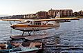
The Inner Harbour is a very popular spot, especially the area in front of the Empress Hotel, which many tourists call "Inner Harbour" but was historically known as "James Bay." Most regular ferries and seaplanes dock here. There's a Canada Border Services Agency office nearby.
Even though BC Ferries has offices in Victoria, their main terminal for the region is further north at Swartz Bay. However, other companies offer ferry services to Victoria Harbour.
| Company | Vessel(s) | Destination | notes |
|---|---|---|---|
| Black Ball Ferry Line | MV Coho | Port Angeles, WA | can carry cars |
| Clipper Navigation | Victoria Clipper, Victoria Clipper III, Victoria Clipper IV | Seattle, WA | fast catamarans |
| Victoria Harbour Ferry Company and H2O Taxi | 12 small launches | intra harbour | seasonal tours and water taxi |
The Inner Harbour is also home to the Victoria Inner Harbour Airport for seaplanes. The route from Victoria to Vancouver Harbour Water Airport is one of Canada's busiest air routes!
Upper Harbour

The Upper Harbour extends north from the Johnson Street Bridge. A small part of it is called "Rock Bay." The Sail and Life Training Society and their tall ship Pacific Swift are located here.
In 1896, a streetcar bridge in this area collapsed in a major disaster.
Selkirk Water
Selkirk Water stretches northwest from the Point Ellice Bridge. The Galloping Goose Regional Trail crosses Selkirk Water on a bridge called the Selkirk Trestle.
Gorge Waters
Gorge Waters goes northwest to the Craigflower Bridge. Along its shore, you'll find the Gorge Waterway Discovery Centre and the Craigflower Manor and Schoolhouse. The Victoria Canoe and Kayak Club also uses these waters.
The Gorge was once a popular swimming spot, but pollution made it unsafe. Thanks to cleanup efforts in recent years, people can now swim there again!
Portage Inlet
Portage Inlet is the innermost part of the harbour. It's home to a large amount of eelgrass growing underwater. This area and the Gorge Waterway might also have the biggest colony of Pacific oysters on the west coast. Creeks flowing into Portage Inlet are important spawning grounds for salmon and herring.
Harbour Facilities


The Greater Victoria Harbour Authority (GVHA) manages many docks and marinas:
- Ogden Point: For cruise ships and cargo ships.
- Fisherman's Wharf: For fishing boats and long-term docking. It also has a fuel dock.
- Causeway Floats: For smaller vessels in the Inner Harbour.
- Ship Point: Can handle vessels up to 75 meters (246 feet) and is often used by seaplanes.
- Wharf Street Marina, Mermaid's Wharf Marina, Johnson Street Floats: For temporary boat mooring in the Inner Harbour.
Other facilities include:
- Westbay Marine Village: A marina in the Outer Harbour.
- Victoria Coast Guard Station: On Shoal Point.
- HMCS Malahat: A naval reserve unit on Shoal Point.
- International Ferry Dock and Black Ball Ferry Dock: For ferries in the Inner Harbour.
- Point Hope Shipyard: Along the Upper Harbour.
- Village Marina and Canoe Marina: Also on the Upper Harbour.
There's a public boat ramp at Ogden Point for smaller boats.
Exciting Sailing Events
Victoria Harbour is a hub for many sailing and boating events:
- The Swiftsure Yacht Race: Held every year since 1930, it's a race out into the Juan de Fuca Strait.
- The Vic-Maui Yacht Race: A long race between Victoria and Lahaina, Hawaii, held every two years since 1968.
- The Victoria Symphony's annual Symphony Splash: A concert held on a barge in the Inner Harbour on BC Day since 1991. Many people watch from boats, canoes, and kayaks!
- The Victoria Dragon Boat Festival: Held annually in the Inner Harbour since 1994.
- A Gorge Canada Day Picnic: Brings thousands of visitors to the Gorge Waterway parks every July 1st.
- The Victoria Tall Ships Festival: Held every three years, featuring impressive tall ships.
- Brotchie Reach Outrigger Canoe Races: A 13.4 km (8.3 miles) race that goes through the Inner, Middle, and Outer Harbours.
Harbour's Natural Environment
.jpg)
Victoria Harbour is an estuary, where fresh water from rivers and creeks mixes with salt water from the ocean.
Some of the freshwater streams that flow into the harbour include:
- Colquitz Creek (which connects to Elk Lake and Swan Lake)
- Craigflower Creek (which connects to Thetis Lakes)
- Cecelia Creek
- James Bay Creek
Portage Inlet has a large area of eelgrass growing underwater, which is important for marine life. Craigflower Creek and Colquitz Creek are vital spawning grounds for Coho salmon. Pacific herring also use Portage Inlet and the Gorge Waterway for spawning.
Victoria Harbour was named a Migratory Bird Sanctuary in 1923, and the Thetis Lakes became Canada's first nature sanctuary in 1958.
Efforts have been made to clean up the harbour. Between 2002 and 2006, over $4 million was spent to clean up properties. There have also been efforts to clean up Rock Bay, which was once the site of a coal gasification plant.
For many years, Victoria and nearby communities released filtered but untreated sewage into the ocean. However, plans are now underway to build wastewater treatment plants to further clean the water.


Images for kids
-
A Turbo Otter seaplane arriving at Victoria Harbour from Seattle's Lake Union

