Westford, Massachusetts facts for kids
Quick facts for kids
Westford, Massachusetts
|
||
|---|---|---|
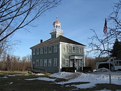
Old Westford Academy,
now the Westford Museum |
||
|
||
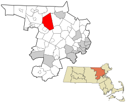
Location in Middlesex County in Massachusetts
|
||
| Country | United States | |
| State | Massachusetts | |
| County | Middlesex | |
| Region | New England | |
| Settled | 1635 | |
| Incorporated | September 23, 1729 | |
| Government | ||
| • Type | Open town meeting | |
| Area | ||
| • Total | 31.3 sq mi (81.1 km2) | |
| • Land | 30.6 sq mi (79.3 km2) | |
| • Water | 0.7 sq mi (1.9 km2) | |
| Elevation | 406 ft (124 m) | |
| Population
(2020)
|
||
| • Total | 24,643 | |
| • Density | 712.1/sq mi (274.8/km2) | |
| Time zone | UTC−5 (Eastern) | |
| • Summer (DST) | UTC−4 (Eastern) | |
| ZIP Code |
01886
|
|
| Area code(s) | 351/978 | |
| FIPS code | 25-76135 | |
| GNIS feature ID | 0618244 | |
Westford is a town located in Middlesex County, Massachusetts, United States. In 2020, about 24,643 people lived there.
Contents
Westford's Past: A Look at History
Westford started as a small village called 'West Chelmsford'. It was part of the town of Chelmsford. In 1729, the village grew big enough to manage itself. On September 23, 1729, it officially became the town of Westford.
Early Industries and Famous Connections
In the late 1700s and early 1800s, Westford was known for making granite, apples, and a type of yarn called worsted. The Abbot Worsted Company was special because it was the first in the country to use camel hair for worsted yarns.
Did you know that Paul Revere's son went to Westford Academy? There's even a bell made by Paul Revere himself in the school's lobby today. A weather vane, also made by Paul Revere, sits on top of the Abbot Elementary school.
Growth and Modern Development
After the American Civil War, roads and transportation got better. Westford started to become a place where people lived if they worked in the factories of nearby Lowell. This was one of the first examples of "suburban sprawl," where towns outside a city grow as people move there. As cars became popular, Westford continued to grow. It became a home for people working in Lowell and later in Boston.
In the 1960s, Westford was part of an interesting science project called Project West Ford. This project involved sending tiny needles into space to help with communication.
By the 1970s, many high-tech companies started to appear along Massachusetts Route 128. Westford became a popular place for people who worked at these companies in towns like Burlington and Woburn. Later, Westford itself became a hub for technology companies.
In the 1990s, many big tech companies had offices in Westford. These included NETSCOUT, Red Hat, Samsung, and Seagate. Most of these companies are located near Massachusetts Route 110 and I-495. Westford was also once the main office for Puma in North America.
Westford's Location and Landscape
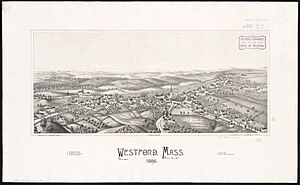
Westford covers about 31.3 square miles (81.1 square kilometers). Most of this area is land, with a small part being water.
 |
Tyngsborough |  |
||
| Groton | Chelmsford | |||
| Littleton | Acton | Carlisle |
Westford is located where a few different regions of Massachusetts meet. These include the Merrimack Valley and Northern Middlesex County.
The town is also divided into smaller areas that people often refer to by name. These include Forge Village, Nabnasset, Graniteville, Parker Village, and the Center of Town.
In 2013, Money.com named Westford as the #11 best place to live.
Westford's Population Over Time
| Historical population | ||
|---|---|---|
| Year | Pop. | ±% |
| 1790 | 1,229 | — |
| 1800 | 1,267 | +3.1% |
| 1810 | 1,330 | +5.0% |
| 1820 | 1,409 | +5.9% |
| 1830 | 1,327 | −5.8% |
| 1840 | 1,436 | +8.2% |
| 1850 | 1,473 | +2.6% |
| 1860 | 1,624 | +10.3% |
| 1870 | 1,803 | +11.0% |
| 1880 | 2,147 | +19.1% |
| 1890 | 2,250 | +4.8% |
| 1900 | 2,624 | +16.6% |
| 1910 | 2,851 | +8.7% |
| 1920 | 3,170 | +11.2% |
| 1930 | 3,600 | +13.6% |
| 1940 | 3,830 | +6.4% |
| 1950 | 4,262 | +11.3% |
| 1960 | 6,261 | +46.9% |
| 1970 | 10,368 | +65.6% |
| 1980 | 13,434 | +29.6% |
| 1990 | 16,467 | +22.6% |
| 2000 | 20,754 | +26.0% |
| 2010 | 21,951 | +5.8% |
| 2020 | 24,643 | +12.3% |
| 2022* | 24,353 | −1.2% |
| * = population estimate. Source: United States Census records and Population Estimates Program data. |
||
The population of Westford has grown a lot over the years. In 2010, there were 21,951 people living in the town. About 45% of households had children under 18. The average family size was about 3 people.
Learning in Westford: Schools and Education
Westford Public Schools
Westford has its own public school system. Christopher Chew is the Superintendent of Westford's Public Schools. Courtney Moran is the Assistant Superintendent.
Here are the public schools in Westford:
- Westford Academy, the public high school.
- Lloyd G. Blanchard Middle School, a public middle school.
- Stony Brook Middle School, another public middle school.
- Norman E. Day Elementary School, for grades 3-5.
- Abbot Elementary, also for grades 3-5.
- John A. Crisafulli Elementary, for grades 3-5.
- Col. John Robinson School, for grades K-2.
- Nabnasset Elementary School, for grades K-2.
- Rita Edwards Miller School, for grades K-2.
Nashoba Valley Technical High School District
Westford is also part of the Nashoba Valley Technical High School District. This school welcomes students from Westford and several other nearby towns.
- Nashoba Valley Technical High School (often called Nashoba Tech or The Tech) is a public high school. It focuses on vocational training, teaching students skills for different jobs. It was started in 1968.
Getting Around Westford: Transportation
Trains travel through Westford every day on the tracks of the old Stony Brook Railroad. This line is important for connecting different parts of Massachusetts, New Hampshire, Vermont, and New York.
Interstate 495 also goes through Westford. This highway helps people travel to other parts of the state and to New Hampshire. US-3 also passes through the town.
The LRTA bus route 15 connects Westford to Chelmsford and the Lowell train station. From there, you can take the MBTA Commuter Rail Lowell Line to other places.
Other local roads that go through Westford include Massachusetts Routes 110, 40, 225, and 27.
Famous People from Westford
Many interesting people have connections to Westford:
- Joel Abbot (1793–1855), a well-known naval officer, was born in Westford.
- Pat Bradley, a famous golfer, is in the World Golf Hall of Fame.
- Michael Fucito, a retired Major League Soccer player.
- Pamela L. Gay, an astronomer.
- Martha Reed Mitchell (1818–1902), known for her charity work and social life.
- Ellen Henrietta Swallow Richards, who helped create the field of home economics. She was the first woman allowed into MIT.
- Lt. Col. John Robinson, a soldier from the American Revolutionary War.
- Aaron Stanford, an actor known for the TV series Nikita.
- Nettie Stevens, an American geneticist.
Fun Places to Visit in Westford
Here are some cool spots to check out in Westford:
- Kimball Farm
- Westford Knight stone and memorial
- Nashoba Valley Ski Area
- Fairview Cemetery
- Haystack Observatory
See also
 In Spanish: Westford (Massachusetts) para niños
 | Audre Lorde |
 | John Berry Meachum |
 | Ferdinand Lee Barnett |


