Weymouth Township, New Jersey facts for kids
Quick facts for kids
Weymouth Township, New Jersey
|
|||
|---|---|---|---|
|
Township
|
|||
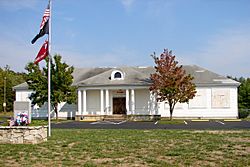
Belcoville Post Office
|
|||
|
|||
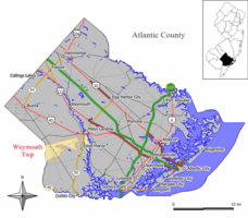
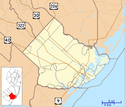
Map of Weymouth Township in Atlantic County. Inset: Location of Atlantic County highlighted in the State of New Jersey.
|
|||
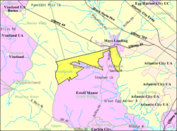
Census Bureau map of Weymouth Township, New Jersey
|
|||
| Country | |||
| State | |||
| County | Atlantic | ||
| Incorporated | February 21, 1798 | ||
| Named for | Weymouth, Dorset | ||
| Government | |||
| • Type | Township | ||
| • Body | Township Committee | ||
| Area | |||
| • Total | 12.17 sq mi (31.52 km2) | ||
| • Land | 11.82 sq mi (30.62 km2) | ||
| • Water | 0.35 sq mi (0.90 km2) 2.84% | ||
| Area rank | 188th of 565 in state 9th of 23 in county |
||
| Elevation | 75 ft (23 m) | ||
| Population
(2020)
|
|||
| • Total | 2,614 | ||
| • Estimate
(2023)
|
2,642 | ||
| • Rank | 463rd of 565 in state 18th of 23 in county |
||
| • Density | 221.1/sq mi (85.4/km2) | ||
| • Density rank | 497th of 565 in state 17th of 23 in county |
||
| Time zone | UTC−05:00 (Eastern (EST)) | ||
| • Summer (DST) | UTC−04:00 (Eastern (EDT)) | ||
| ZIP Code |
08330 – Mays Landing
|
||
| Area code(s) | 609 exchanges: 476, 625, 909 | ||
| FIPS code | 3400180330 | ||
| GNIS feature ID | 0882050 | ||
Weymouth Township is a small town, also called a township, located in Atlantic County, New Jersey. In 2020, about 2,614 people lived here. This was a small drop from 2010, but the town had grown quite a bit since 2000.
The township is named after Weymouth, Dorset, a place in England. It was first set up in 1694 and was known as "New Waymouth Township." Weymouth Township officially became a town on February 21, 1798. This happened while the area was still part of Gloucester County.
Over the years, parts of Weymouth Township were used to create other towns. For example, Hamilton Township was formed in 1813. Then, in 1837, Weymouth Township became part of the new Atlantic County. Later, Corbin City was formed in 1922, and Estell Manor in 1925, both from parts of Weymouth.
Weymouth Township is in the South Jersey area of the state. It's also part of a larger area that includes Atlantic City and Hammonton. This bigger area is connected to the major cities of Philadelphia, Reading, and Camden.
Contents
About Weymouth Township's Location
Weymouth Township covers about 12.17 square miles (31.52 square kilometers). Most of this area is land, with a small part being water.
Nearby Communities and Features
Several small communities and places are found partly or fully within Weymouth Township. These include Belcoville, Dorothy, Grassy Pond, and High Bank Landing.
The township shares its borders with several other towns. In Atlantic County, it borders Buena Vista Township, Egg Harbor Township, Estell Manor, and Hamilton Township. It also borders Maurice River Township in Cumberland County.
The Pinelands National Reserve
Weymouth Township is special because it's part of the New Jersey Pinelands National Reserve. This is a huge protected natural area, covering about 1.1 million acres. It's known for its unique plants and animals. The Pinelands was set up by the government in 1978 to protect this important natural space.
How Many People Live Here?
| Historical population | |||
|---|---|---|---|
| Census | Pop. | %± | |
| 1810 | 1,029 | — | |
| 1820 | 787 | * | −23.5% |
| 1830 | 1,270 | 61.4% | |
| 1840 | 1,158 | −8.8% | |
| 1850 | 1,032 | −10.9% | |
| 1860 | 823 | −20.3% | |
| 1870 | 810 | −1.6% | |
| 1880 | 741 | −8.5% | |
| 1890 | 538 | −27.4% | |
| 1900 | 972 | 80.7% | |
| 1910 | 899 | −7.5% | |
| 1920 | 1,166 | 29.7% | |
| 1930 | 685 | * | −41.3% |
| 1940 | 675 | −1.5% | |
| 1950 | 750 | 11.1% | |
| 1960 | 788 | 5.1% | |
| 1970 | 998 | 26.6% | |
| 1980 | 1,260 | 26.3% | |
| 1990 | 1,957 | 55.3% | |
| 2000 | 2,257 | 15.3% | |
| 2010 | 2,715 | 20.3% | |
| 2020 | 2,614 | −3.7% | |
| 2023 (est.) | 2,642 | −2.7% | |
| Population sources: 1810–1830 1840–2000 1810–1920 1840 1850–1870 1850 1870 1880–1890 1890–1910 1910–1930 1940–2000 2000 2010 2020 * = Lost territory in previous decade. |
|||
What the 2010 Census Showed
In 2010, there were 2,715 people living in Weymouth Township. They lived in 1,153 homes, with 762 of these being families. The town had about 225 people per square mile.
Most of the people (92%) were White. About 4.75% were Black or African American, and less than 1% were Native American or Asian. About 4.57% of the population was Hispanic or Latino.
About 17% of the people were under 18 years old. Around 27% were 65 or older. The average age in the township was 49.8 years.
The average income for a household was about $51,574. For families, it was around $67,857. About 8% of the people in the township lived below the poverty line.
Schools in Weymouth Township
The Weymouth Township School District is where students in pre-kindergarten through eighth grade go to school. There is one school, Weymouth Township School. In the 2022–23 school year, about 161 students attended this school. This means there was about one teacher for every 9 or 10 students.
High School Education
For high school, students from Weymouth Township go to Buena Regional High School. This is part of an agreement with the Buena Regional School District. Students from Buena, Buena Vista Township, and Estell Manor also attend this high school. In 2022–23, the high school had about 496 students.
Students can also choose to attend special schools. These include the Atlantic County Institute of Technology in Mays Landing. Another option is the Charter-Tech High School for the Performing Arts in Somers Point.
Getting Around Weymouth Township
Roads and Highways
As of 2010, Weymouth Township had about 36.90 miles of roads. The town itself took care of most of these roads. Atlantic County and the New Jersey Department of Transportation also maintained some roads.
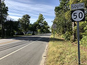
New Jersey Route 50 (also called Boulevard) is the main highway that goes through Weymouth Township.
Public Transportation
NJ Transit offers bus service in the township. The 315 bus route connects Cape May to Philadelphia.
Famous People from Weymouth Township
Some notable people who have lived in or are connected to Weymouth Township include:
- Frances Edelstein (1926–2018): A businesswoman who ran a famous restaurant called Cafe Edison in New York City.
- Kathleen Karr (1946–2017): An author who wrote historical novels for children and young adults.
- Walter Lowenfels (1897–1976): A poet and journalist.
- William Moore (1810–1878): He served as a representative for New Jersey in the United States House of Representatives.
- Rhoda Scott (born 1938): A talented soul jazz organist and singer.
See also
 In Spanish: Municipio de Weymouth para niños
 | James B. Knighten |
 | Azellia White |
 | Willa Brown |


