
Yatton facts for kids
Quick facts for kids Yatton |
|
|---|---|
 Church of St Mary |
|

Yatton
|
|
| Population | 7,552 |
| OS grid reference | ST425655 |
| Unitary authority | |
| Ceremonial county | |
| Region | |
| Country | England |
| Sovereign state | United Kingdom |
| Post town | BRISTOL |
| Postcode district | BS49 |
| Dialling code | 01934 |
| Police | Avon and Somerset |
| Fire | Avon |
| Ambulance | Great Western |
| EU Parliament | South West England |
| UK Parliament |
|
Yatton is a village and a local government area called a civil parish in North Somerset, England. It's part of the larger ceremonial county of Somerset. Yatton is about 11 miles (18 km) south-west of Bristol. In 2011, about 7,552 people lived there. The parish also includes a smaller village called Claverham, which used to be a farming area.
We're not entirely sure how Yatton got its name, but people have lived here for a very long time. There are signs of an Iron Age hill fort and a Roman villa nearby. When the railway arrived in the 1800s, and with new roads built more recently, Yatton grew a lot. Many people who work in nearby cities now live in Yatton. The village also has its own businesses and factories. Yatton is located on the North Somerset Levels, which is a low-lying area with many small rivers and streams. This makes it a special home for some rare plants and animals.
The Church of St Mary was built in the 14th century. Yatton also has other places of worship, sports clubs, and community groups for people to join.
Contents
Discovering Yatton's Past
How Yatton Got Its Name
The name Yatton has a bit of a mystery! It might come from an old Anglo-Saxon word, 'gatton', which means 'village on the track'. This track could have been a limestone path leading from Cadbury Hill. Over time, the village has been called different names like Jatune and Eaton. In a very old book called the Domesday Book, it was recorded as Lature.
Ancient Times in Yatton
Yatton was a well-known village even before the Normans arrived in England. It sits on slightly higher, drier ground surrounded by moorland. People have found remains of an Iron Age hill fort on Cadbury Hill. They also found parts of a Roman villa, a temple, and a collection of Roman coins. Older Christian burial sites have also been found on Cadbury Hill.
The Railway Arrives

In the 1840s, the Bristol & Exeter Railway opened, with the famous engineer Isambard Kingdom Brunel helping to design it. The station in Yatton was first called Clevedon Road. It was renamed Yatton Junction when a branch line to Clevedon was built in 1847. Later, other lines were added, going to Cheddar and Wells, and another to Blagdon.
_GHP.jpg)
Even though most of these branch lines closed in the 1930s and 1960s, the main Yatton station, designed by Brunel, is still used today. You can even walk or cycle along the old railway path, known as the Strawberry Line, from Yatton to Cheddar. This path is named after the strawberries that used to be transported from Cheddar! A local group also opened a community cafe in the old waiting room at the station in 2010.
Yatton in the 1900s

In 1922, the Yatton Parish War Memorial was built to remember villagers who died in the First and Second World Wars. Every year on Remembrance Sunday, people march from St Mary's Church to the memorial to lay wreaths.
The village has continued to grow, with new homes being built. Yatton, Claverham, and Cleeve are now almost connected because of this growth. Cadbury House Country Club has also been developed into a hotel and leisure center.
How Yatton is Governed
Yatton has a parish council made up of 18 members. This council looks after local issues. They decide on a local tax to cover costs and check building plans. They also work with the police and other groups on crime, safety, and traffic. The council helps maintain village facilities like the village hall, playing fields, and playgrounds. They also talk to the main council about roads, drainage, footpaths, public transport, and keeping streets clean. Looking after old buildings and the environment is also important to them.
Yatton is part of the unitary authority of North Somerset. This council was created in 1996 and handles most local government tasks. This includes things like planning for new buildings, roads, housing, and rubbish collection. They also manage education, social services, libraries, and parks. Fire, police, and ambulance services are shared with other areas.
North Somerset is part of the ceremonial county of Somerset, but it is run separately. Its main office is in Weston-super-Mare.
Yatton's Location and Nature

The area around Yatton and Claverham is part of the North Somerset Levels. It's a mix of different soils and low hills made of sand and gravel. To the south is the limestone ridge of Cadbury Hill, which is about 250 feet (76 meters) high. On top of Cadbury Hill, there's an Iron Age hill fort. It was built with walls and ditches to protect an area of about 8.5 acres (3.4 hectares).
A special area called Biddle Street has been marked as a Site of Special Scientific Interest. This means its watercourses are home to many different water plants. Some rare plants found here include rootless duckweed and hairlike pondweed.
Yatton has a mild and wet climate, like the rest of South West England. The average temperature is about 10°C (50°F). July and August are the warmest months, around 21°C (70°F). January is the coldest, between 1°C (34°F) and 2°C (36°F). It rains about 800–900 mm (31–35 inches) each year.
Yatton's Population and Businesses
After the Second World War, Yatton grew a lot in size and population. With good railway and road links to places like Weston-super-Mare, Bristol, and London, many new homes were built. Today, there are many more modern buildings than older ones. In 2001, Yatton's population was 9,176.

Yatton is a large village with a shopping area called Page's Court, also known as 'The Precinct'. It has a supermarket and other local shops.
There are several successful local businesses, including Pullin's Bakers, Costain Technology Solutions, and Smart Systems. Farming is still an important activity in the area.
Education in Yatton
The local education authority for Yatton is North Somerset Council. Yatton has a pre-school, an infant school, and a junior school for younger children.
For secondary education (ages 11-18), most children from Yatton travel to Backwell to attend Backwell School. This school is known for its arts programs and has a sixth form for older students. In 2008, Backwell School was rated as "outstanding" by Ofsted, which inspects schools in England.
Places of Worship

St Mary's Church in central Yatton was built around 1400. It's sometimes called the "Cathedral of the Moors" because it's so large for a village church. It has tall towers with pointed tops and beautiful stained glass windows showing the symbols of local lords. English Heritage has given it a special Grade I listed building status, meaning it's a very important historic building. The Old Rectory, a house built in the 15th century, also has Grade I status.
Besides St Mary's (Church of England), Yatton has Methodist, Catholic, and other churches. Yatton Methodist Church is on the High Street. Horsecastle Chapel is an independent church, and River of Life Church meets at Yatton Infant School. St Dunstan's is a small Catholic church on Claverham Road.
The church of St. Barnabas in Claverham was built in 1879 and is a Grade II listed building. These churches, along with others in Kenn, Cleeve, and Kingston Seymour, are part of the Yatton Moor Team Ministry.
Sports and Activities
Yatton has active clubs for cricket, football, and rugby. There are two parks, Hangstones and Rock Road, and several public houses. Many other fun activities and sports are available, including the Cleeve Claverham and Yatton Scout Group.
Yatton Rugby Club started in 1968. In 2016, they won their league and moved up to a higher division. They have three adult teams and many junior teams for younger players.
Claverham (Yatton) Cricket Club was formed in 1905. They offer cricket for all ages and skill levels. Their main teams play in the ECB West of England Premier League.
Public Services

Yatton fire station opened in 1947. The current station building was built in 1973. Today, Yatton fire station is part of Avon Fire and Rescue Service. It has two fire engines and a special hose-laying vehicle.
The firefighters in Yatton work on a "retained duty system." This means they don't work at the station all the time but are called in when there's an emergency. They cover a large area of about 62 square miles (160 km2), including Yatton, Cleeve, Kingston Seymour, Congresbury, Wrington, and Blagdon. They respond to about 130–150 calls each year, from small grass fires to major incidents and road accidents on the busy A370 road. In 2010, Yatton Fire Station was named the "highest performing retained duty station" by the Avon Fire and Rescue Service.
Famous People from Yatton
George Lukins, sometimes called the Yatton daemoniac, was known for a story about him in 1788. Ken Day, a cricketer, was born in Yatton in 1919. He played for Somerset County Cricket Club between 1950 and 1956. Richard Foord, a politician, lived in Yatton for 19 years.
Images for kids
-
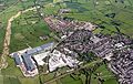
View of the northern part of Yatton and the Smart Systems plant.

See also
 In Spanish: Yatton para niños
