
York Harbor, Maine facts for kids
Quick facts for kids
York Harbor, Maine
|
|
|---|---|

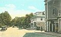
York Street and the Lancaster Building, c. 1922
|
|

York Harbor, Maine
Location in Maine
|
|
| Country | United States |
| State | Maine |
| County | York |
| Area | |
| • Total | 3.49 sq mi (9.05 km2) |
| • Land | 3.21 sq mi (8.30 km2) |
| • Water | 0.29 sq mi (0.75 km2) |
| Elevation | 46 ft (14 m) |
| Population
(2020)
|
|
| • Total | 3,132 |
| • Density | 976.92/sq mi (377.22/km2) |
| Time zone | UTC-5 (Eastern (EST)) |
| • Summer (DST) | UTC-4 (EDT) |
| ZIP codes |
03910-03911
|
| Area code(s) | 207 |
| FIPS code | 23-88160 |
| GNIS feature ID | 0578771 |
York Harbor is a special area in the town of York, located in York County, Maine, United States. It is known as a census-designated place (CDP). In 2020, about 3,132 people lived there. York Harbor was once a popular summer spot during the Gilded Age, a time when many wealthy people built fancy homes. It is part of the larger metropolitan area in Maine.
Contents
History of York Harbor

York was a busy seaport in the 1700s. Its harbor, then called Lower Town, had many wharves and warehouses. People from upriver brought their goods here to trade and ship. A piece of land at the mouth of the York River was known as Gallows Point. This was where punishments were carried out for people from Old York Gaol. At high tide, this land became an island. A ferry started operating from here in 1652, crossing to Seabury.
Changes During the American Revolution
During the American Revolution, many fishermen and their families left the Isles of Shoals off the coast. They moved their homes to the Lower Town waterfront and rebuilt them there. They pulled their boats ashore at Lobster Cove and dried their fish on special racks. This area of land was then named Stage Neck. In 1807, a law called the Embargo Act made it hard for local businesses to trade. By the time of the Civil War, Stage Neck had become a run-down area.
The Rise of a Summer Resort
After the Civil War, a lawyer named Nathaniel Grant Marshall had an idea. He wanted to turn the poorest part of Lower Town into a fancy summer place for rich visitors. In 1871, he bought Stage Neck and removed the old fishing shacks. He then built a large hotel called the Marshall House. To make it sound more appealing, Lower Town was renamed York Harbor.

Steamers started bringing families to the Maine coast. People came to escape the heat and pollution of big cities like Boston, New York, and Philadelphia. Many visitors loved the area so much that they built large summer homes. These homes were often built in the Shingle Style during the 1880s and 1890s. Soon, York Harbor became a fashionable summer spot, much like Bar Harbor and Newport.
Hotels and Local Development
Other hotels, like Harmon Hall and the Albracca Hotel, were also built. The Marshall House was the biggest, with room for 325 guests by 1900. It offered many services, including telephone and telegraph offices. Guests could also enjoy horseback riding, swimming, tennis courts, and a barbershop. There was also a billiards room, a ballroom, and options for sailing and fishing. The Marshalls also started an electric and water company. They helped build the York Harbor & Beach Railroad, which opened in 1887.
When the Marshall House burned down in 1916, it was rebuilt the next year. The new building was made of fire-resistant brick. It continued to be the center of social life in York Harbor. Fancy cars brought guests in evening gowns and tuxedoes for dinner and parties. There was often chamber music played by musicians from the Boston Symphony Orchestra.
Community Differences and Reconciliation
Over time, a disagreement grew between York Harbor and York Beach. York Beach attracted people who were not as wealthy. York Harbor did not like York Beach's "cottage and campground" style. They even tried to stop the trolley that connected the two areas. In 1908, York Harbor suggested becoming a separate town. They wanted to call it Yorktown or Gorges. However, this plan failed because it would have taken away important parts of York, like the town hall. Eventually, the two parts of York made up.

Most of the building in York Harbor happened between the 1870s and the 1920s. This means many buildings show the style of that time. Today, many of these old resort buildings are used all year round. The Marshall House was sold in 1957 and taken down in 1972. A new hotel, the Stage Neck Inn, and condominiums were built there.
York Harbor still has many beautiful buildings from the past. These include the Lancaster Building (built in 1895), Trinity Episcopal Church (built in 1908), and the York Harbor Reading Room (built in 1910). The Cliff Walk is an old path along the shoreline. It is lined with beach roses and offers great views of the ocean.
Geography of York Harbor
York Harbor is located at 43°8′33″N 70°38′50″W / 43.14250°N 70.64722°W. The York Harbor CDP includes all of York Village to the west. The western edge of the CDP is U.S. Route 1. The York River forms the southern border. The northern border is next to the southern part of the Cape Neddick CDP, which is also known as York Beach. The Gulf of Maine, which is part of the Atlantic Ocean, is to the east.
The United States Census Bureau says that the CDP covers about 3.5 square miles (9.05 square kilometers). Of this, about 3.2 square miles (8.30 square kilometers) is land, and 0.3 square miles (0.75 square kilometers), or 8.23%, is water.
Population and People

Based on the 2020 census, York Harbor had a population of 3,132 people.
In 2000, there were 3,321 people living in the CDP. There were 1,334 households and 895 families. The population density was about 1,035.6 people per square mile (399.8 per square kilometer). There were 1,601 housing units. Most people were White (98.13%).
About 28.1% of households had children under 18. Most households (58.5%) were married couples. The average household had 2.35 people, and the average family had 2.88 people.

The population was spread out by age. About 21.9% were under 18 years old. About 23.7% were 65 years or older. The average age was 46 years.
The median income for a household in 2000 was $53,969. For a family, it was $71,164. The per capita income for the CDP was $29,016. A small number of families (1.0%) and people (5.3%) lived below the poverty line.
Images for kids
-
York Street and the Lancaster Building, c. 1922
See also
 In Spanish: York Harbor para niños
